
Past Storms
2021 Hurricane Ida
September 7 @ 4:00 p.m. – Ida Recovery Phase, Update 13
GLPC STORM RECOVERY PHASE
Hurricane Ida
UPDATE #13
September 7, 2021
4:00 p.m.
Port Fourchon continues to progress through Recovery Phase in the aftermath of Hurricane Ida with an emphasis on getting our tenants back to work. Port tenants have been given full access to return to their facilities, and as of today, September 7, several of our larger tenants have either returned to operations or are readying themselves for operations in the port.
PROGRESS SO FAR:
- On Sunday, August 29, Port Fourchon took a direct hit from Hurricane Ida.
- By Tuesday, August 31, Port Commission personnel had gained access to Port Fourchon and started clearing debris to and within the port.
- These efforts extended into Wednesday, September 1, prior to allowing our tenant assessment teams into Port Fourchon to begin surveying damage on Thursday and Friday.
- On Friday, September 3, our main channel at Belle Pass was deemed safe for travel in and out of Port Fourchon with restrictions.
ACCESS TO PORT FOURCHON:
- ROADWAYS: Roadways are clear to and within Port Fourchon. Please use caution when traveling recently cleared roadways. LA 1 to Grand Isle is now accessible for property and business owners and emergency services, with limited access in that direction.
- PORT WATERWAYS: Vessels can travel in port waterways. US Coast Guard is allowing conditional access to Port Fourchon waterways, including Belle Pass, with restrictions for daylight operations only. Although there are restrictions in place, there are NO MAJOR OBSTRUCTIONS in port waterways that could hamper maneuverability into or out of Port Fourchon. Navigation through the main channel in Belle Pass is one lane only, with no meeting or overtaking in the channel. CLICK HERE to view Marine Safety Information Bulletin MSIB 028-21 for details.
- BAYOU LAFOURCHE: Bayou Lafourche north of the port is closed to marine traffic due to multiple obstructions in the channel, especially between the Ted Gisclair Floodgate in Larose and the Leon Theriot Lock in Golden Meadow.
NOTABLE INFORMATION:
- CURFEWS: There is a dusk to dawn curfew in effect for Port Fourchon, with no vehicular or marine traffic in port overnight. Port Fourchon Harbor Police remain on duty to monitor traffic and ensure the safety of the port and returning crews.
- POWER, FUEL, & SUPPLIES: Be prepared to be self-sufficient in Port Fourchon. There is no power and little to no running water. There are no gas stations or restaurants currently open. Access is limited to parish curfew hours.
- CLEANUP & DEBRIS: The Port Commission asks that as you begin to clean the debris from your business property, that you NOT place debris along the side of the roadway. You must stack debris within the footprint of your facility, as there is no debris staging area in port.
- EMERGENCY SERVICES: Temporary fire and emergency services have been established in Port Fourchon, and Port Fourchon Harbor Police are continually working security for the area from a law enforcement perspective.
All these efforts are ongoing, but the underlying message is that we are moving forward as a port, as a community, and as Fourchon family, together.
Thank you for your support in getting us all back to business safely in Port Fourchon.
October 14 @ 11:00 a.m. – Ida Recovery Phase, Update 25 FINAL
GLPC STORM RECOVERY PHASE – FINAL UPDATE
Hurricane Ida
UPDATE #25
October 14, 2021
11:00 a.m.
Port Fourchon is ending all GLPC Storm Phases for Hurricane Ida.
FINAL IDA RECOVERY INFORMATION:
- DEBRIS REMOVAL: The one-time pickup of large-scale debris for Port Fourchon facilities is underway. Contractors are loading stacked and separated storm debris piles along public rights-of-way or near facility entrances. After this one approved pass, the remainder of any facility’s debris is thereafter the responsibility of the tenant business.
- POWER AT PORT: Power restoration is nearly complete in Port Fourchon.
- ROADWAYS: Roadways are clear to and within Port Fourchon.
- PORT WATERWAYS: Port Fourchon waterways are open for 24/7 operations.
- BAYOU LAFOURCHE: The Bayou Lafourche channel is open to vessel traffic from Larose to Fourchon. Mariners are advised to remain cautious and follow Coast Guard guidelines post-storm.
- EMERGENCY STORM HARBOR MARINA: The Emergency Storm Harbor Marina has been deactivated and is now closed.
- WATER: The Lafourche Parish Water District has restored water supply to Port Fourchon. A boil water advisory remains in place for all areas south of the Golden Meadow floodgates.
- COMMUNICATIONS: Most cell service has been restored in Port Fourchon.
- EMERGENCY SERVICES: Operational in Port Fourchon.
- TENANT FACILITIES: Roughly 75% of port tenants are back to full operations in Port Fourchon.
- COMMERCIAL FUEL: Available at multiple operational tenant sites in Fourchon, including Stone Fuel, C-Port Stone, Martin 16, and Harvey Fuel.
- FOOD, GAS, & SUPPLIES: Food, gas and supplies are coming back online in Port Fourchon.
- GREATER LAFOURCHE PORT COMMISSION ADMINISTRATION OFFICE: We’ve moved! Temporarily. Due to storm damage to our GLPC Admin office building at 16829 East Main Street, we have relocated to the newly acquired building directly behind GLPC Admin. Our temporary physical address is 131 East 91st Street, Cut Off, LA 70345. Our phone numbers remain the same.
Thank you for staying informed with us through Hurricane Ida and her aftermath, and thank you for your support in getting us back to business safely in Port Fourchon.
October 5 @ 8:45 a.m. – Ida Recovery Phase, Update 24
GLPC STORM RECOVERY PHASE
Hurricane Ida
UPDATE #24
October 5, 2021
8:45 a.m.
Port Fourchon’s Recovery Phase continues post-Ida as we make continual progress.
LATEST UPDATES:
- DEBRIS: The Greater Lafourche Port Commission has been granted approval for a ONE-TIME PICKUP of large-scale debris for Fourchon facilities on port property. Port businesses may begin stacking storm debris along public rights-of-way or alongside facility entrances with the following guidelines:
- When placing storm debris, ensure contractors have clear, safe road access to load debris
- Separate debris into three piles:
- Marsh vegetation/grass
- Construction and demolition material
- Metals
- NOTE: No white goods (i.e., appliances) will be removed as part of this pickup. You are responsible for disposing of your facility’s white goods.
- DO NOT place debris:
- Directly under power lines or blocking utility restoration access
- In ditches
- Near water meters
- Near fire hydrants
- Please place all debris by next Tuesday, October 12, 2021. Removal is scheduled to start Wednesday, October 13, 2021. The remainder of your facility’s debris is thereafter your responsibility.
- NOTICE: This is for port businesses within the Port Fourchon footprint only and does not include camps or residences.
- POWER AT PORT: Entergy continues working toward power restoration in Port Fourchon, however, issues with repairing transmission lines have caused some delays. As crews make progress in getting port facilities back online safely, tenant companies can expect to be in contact with Entergy for exchange of additional account information.
ACCESS TO PORT FOURCHON: OPEN
- ROADWAYS: Roadways are clear to and within Port Fourchon.
- PORT WATERWAYS: Both Belle Pass and Port Fourchon waterways are open for 24/7 operations.
- BAYOU LAFOURCHE: The Bayou Lafourche channel south of the Intracoastal Canal is now open to vessel traffic. Mariners are advised to use caution between there and Leeville due to multiple dive teams working in various sections of the waterway. See US Coast Guard MSIB 037-21 for navigation information regarding safe passage near divers.
- TENANT FACILITIES: Port tenants have been given full access to return to their facilities. Tenants’ employees should contact their employers for specific information on returning to work in Port Fourchon.
STORM RECOVERY INFORMATION:
- WATER: The Lafourche Parish Water District has restored water supply to Port Fourchon. A boil water advisory remains in place for all areas south of the Golden Meadow floodgates.
- COMMUNICATIONS: Most cell service has been restored.
- EMERGENCY SERVICES: Operational in Port Fourchon.
NOTABLE INFORMATION:
- COMMERCIAL FUEL: Available at multiple operational tenant sites in Fourchon, including Stone Fuel, C-Port Stone, Martin 16, and Harvey Fuel.
- FOOD, GAS, & SUPPLIES: There are no convenience stores, gas stations, or restaurants open at this time.
- GREATER LAFOURCHE PORT COMMISSION ADMINISTRATION OFFICE: We’ve moved! Temporarily. Due to storm damage to our GLPC Admin office building at 16829 East Main Street, we have relocated to the newly acquired building directly behind GLPC Admin. Our temporary physical address is 131 East 91st Street, Cut Off, LA 70345. Our phone numbers remain the same.
Thank you for your support in getting us all back to business safely in Port Fourchon.
October 1 @ 5:45 p.m. – Ida Recovery Phase, Update 23
GLPC STORM RECOVERY PHASE
Hurricane Ida
UPDATE #23
October 1, 2021
5:45 p.m.
Port Fourchon’s Recovery Phase continues post-Ida as we make continual progress.
LATEST UPDATES:
- BAYOU LAFOURCHE: The Bayou Lafourche channel south of the Intracoastal Canal is now open to vessel traffic. Mariners are advised to use caution between there and Leeville due to multiple dive teams working in various sections of the waterway. See US Coast Guard MSIB 037-21 for navigation information regarding safe passage near divers.
ACCESS TO PORT FOURCHON: OPEN
- ROADWAYS: Roadways are clear to and within Port Fourchon.
- PORT WATERWAYS: Both Belle Pass and Port Fourchon waterways are open for 24/7 operations.
- TENANT FACILITIES: Port tenants have been given full access to return to their facilities. Tenants’ employees should contact their employers for specific information on returning to work in Port Fourchon.
STORM RECOVERY INFORMATION:
- DEBRIS: Port businesses are asked to continue stacking storm debris within the footprints of their facilities so as not to impede access by utility workers getting services restored in port. While there is no debris staging area in port, the port commission is making arrangements for a ONE TIME PASS for large-scale debris pickup once utility work is done and public rights-of-way are cleared for use. Stay tuned for an update sharing details. We will give port tenants time to collect their debris and move it to the roadside ahead of the debris pickup date. The remainder of your facility’s debris is thereafter your responsibility. Please do NOT place debris along the side of the roadway until you are cleared to do so.
- POWER AT PORT: Entergy is working to restore power to Port Fourchon facilities and get tenant companies back online safely.
- WATER: The Lafourche Parish Water District has restored water supply to Port Fourchon. A boil water advisory remains in place for all areas south of the Golden Meadow floodgates.
- COMMUNICATIONS: Most cell service has been restored.
- EMERGENCY SERVICES: Operational in Port Fourchon.
NOTABLE INFORMATION:
- COMMERCIAL FUEL: Available at multiple operational tenant sites in Fourchon, including Stone Fuel, C-Port Stone, Martin 16, and Harvey Fuel.
- FOOD, GAS, & SUPPLIES: There are no convenience stores, gas stations, or restaurants open at this time.
- GREATER LAFOURCHE PORT COMMISSION ADMINISTRATION OFFICE: We’ve moved! Temporarily. Due to storm damage to our GLPC Admin office building at 16829 East Main Street, we have relocated to the newly acquired building directly behind GLPC Admin. Our temporary physical address is 131 East 91st Street, Cut Off, LA 70345. Our phone numbers remain the same.
Thank you for your support in getting us all back to business safely in Port Fourchon.
September 29 @ 4:30 p.m. – Ida Recovery Phase, Update 22
GLPC STORM RECOVERY PHASE
Hurricane Ida
UPDATE #22
September 29, 2021
4:30 p.m.
Port Fourchon’s Recovery Phase continues post-Ida as we make continual progress.
LATEST UPDATES:
- BAYOU LAFOURCHE: The Bayou Lafourche channel south of the Galliano (Tarpon) Lift Bridge, known locally as the South Lafourche Bridge, is now open to vessel traffic. Mariners are advised to use caution between there and Leeville due to multiple dive teams working in various sections of the waterway. See US Coast Guard MSIB 036-21 for navigation information regarding safe passage near divers. Bayou Lafourche remains closed to marine traffic north of the South Lafourche Bridge. If there is an urgent need to transit this area, all waterway users are directed to contact the US Coast Guard by emailing smb-msuhoumamtsru@uscg.mil or calling Sector New Orleans Command Center at 504-365-2544.
ACCESS TO PORT FOURCHON: OPEN
- ROADWAYS: Roadways are clear to and within Port Fourchon. LA 1 to Grand Isle has limited access for property and business owners and emergency services.
- PORT WATERWAYS: The US Coast Guard has set Port Fourchon as Port Condition: Normal with Restrictions. Both Belle Pass and Port Fourchon waterways are open for 24/7 operations.
- TENANT FACILITIES: Port tenants have been given full access to return to their facilities. Tenants’ employees should contact their employers for specific information on returning to work in Port Fourchon.
- DEBRIS: Port businesses are asked to continue stacking storm debris within the footprints of their facilities so as not to impede access by utility workers getting services restored in port. While there is no debris staging area in port, the port commission is making arrangements for a ONE TIME PASS for large-scale debris pickup once utility work is done and public rights-of-way are cleared for use. Stay tuned for an update sharing details. We will give port tenants time to collect their debris and move it to the roadside ahead of the debris pickup date. The remainder of your facility’s debris is thereafter your responsibility. Please do NOT place debris along the side of the roadway until you are cleared to do so.
NOTABLE INFORMATION:
- POWER AT PORT: Entergy is working with port tenant companies this week to bring their facilities back online safely.
- WATER: The Lafourche Parish Water District has restored water supply to Port Fourchon. A boil water advisory remains in place for all areas south of the Golden Meadow floodgates. Please report any outages or possible leaks to the Water District at 985-532-6924.
- COMMUNICATIONS: Most cell service has been restored.
- COMMERCIAL FUEL: Stone Fuel, C-Port Stone, Martin 16, and Harvey Fuel are all operational.
- FOOD, GAS, & SUPPLIES: There are no convenience stores, gas stations, or restaurants open at this time.
- EMERGENCY SERVICES: Fire and emergency services have been established in Port Fourchon, and Port Fourchon Harbor Police are continually working security for the area from a law enforcement perspective.
- SOUTH LAFOURCHE FLOODGATE/LOCK OPERATIONS: The South Lafourche Levee District has resumed its regularly scheduled openings. Visit slld.org for more information.
- GREATER LAFOURCHE PORT COMMISSION ADMINISTRATION OFFICE: We’ve moved! Temporarily. Due to storm damage to our GLPC Admin office building at 16829 East Main Street, we have relocated to the newly acquired building directly behind GLPC Admin. Our temporary physical address is 131 East 91st Street, Cut Off, LA 70345. Our phone numbers remain the same.
Thank you for your support in getting us all back to business safely in Port Fourchon.
September 27 @ 1:45 p.m. – Ida Recovery Phase, Update 21
GLPC STORM RECOVERY PHASE
Hurricane Ida
UPDATE #21
September 27, 2021
1:45 p.m.
Port Fourchon’s Recovery Phase continues post-Ida as we make continual progress.
LATEST UPDATES:
- POWER AT PORT: Entergy is working with port tenant companies this week to bring their facilities back online safely.
- POWER AT AIRPORT: The South Lafourche Airport in Galliano is back online with Entergy, including airfield and operations, as of Saturday, September 25.
- BAYOU LAFOURCHE: Per US Coast Guard MSIB 035-21, Bayou Lafourche remains closed to marine traffic north of Leeville, including the area between the Ted Gisclair Floodgate in Larose and the Leon Theriot Lock in Golden Meadow. The Corps is asking vessel operators to comply with this guidance. This is in the interests of safety as multiple salvage crews, crane barges, divers, emergency response teams, and survey crews work from north and south clearing out the sunken vessels and obstructions located in and along the navigable channel. They are making multiple passes, so areas that may appear clear may not actually be so. In the meantime, we ask that all vessels remain clear of salvage work areas until they are officially declared open. If there is an urgent need to transit this area, all waterway users are directed to contact the US Coast Guard by emailing
smb-msuhoumamtsru@uscg.mil or calling Sector New Orleans Command Center at 504-365-2544.
ACCESS TO PORT FOURCHON: OPEN
- ROADWAYS: Roadways are clear to and within Port Fourchon. LA 1 to Grand Isle has limited access for property and business owners and emergency services.
- PORT WATERWAYS: The US Coast Guard has set Port Fourchon as Port Condition: Normal with Restrictions. Both Belle Pass and Port Fourchon waterways are open for 24/7 operations.
- TENANT FACILITIES: Port tenants have been given full access to return to their facilities. Tenants’ employees should contact their employers for specific information on returning to work in Port Fourchon.
- DEBRIS: Port businesses are asked to continue stacking storm debris within the footprints of their facilities so as not to impede access by utility workers getting services restored in port. While there is no debris staging area in port, the port commission is making arrangements for a ONE TIME PASS for large-scale debris pickup once utility work is done and public rights-of-way are cleared for use. Stay tuned for an update sharing details. We will give port tenants time to collect their debris and move it to the roadside ahead of the debris pickup date. The remainder of your facility’s debris is thereafter your responsibility. Please do NOT place debris along the side of the roadway until you are cleared to do so.
NOTABLE INFORMATION:
- WATER: The Lafourche Parish Water District has restored water supply to Port Fourchon. Please report any outages or possible leaks to the Water District at 985-532-6924.
- COMMUNICATIONS: Most cell service has been restored.
- COMMERCIAL FUEL: Stone Fuel, C-Port Stone, Martin 16, and Harvey Fuel are all operational.
- FOOD, GAS, & SUPPLIES: There are no convenience stores, gas stations, or restaurants open at this time.
- EMERGENCY SERVICES: Fire and emergency services have been established in Port Fourchon, and Port Fourchon Harbor Police are continually working security for the area from a law enforcement perspective.
- SOUTH LAFOURCHE FLOODGATE/LOCK OPERATIONS: The South Lafourche Levee District has resumed its regularly scheduled openings. Visit www.slld.org for more information.
- GREATER LAFOURCHE PORT COMMISSION ADMINISTRATION OFFICE: We’ve moved! Temporarily. Due to storm damage to our GLPC Admin office building at 16829 East Main Street, we have relocated to the newly acquired building directly behind GLPC Admin. Our temporary physical address is 131 East 91st Street, Cut Off, LA 70345. Our phone numbers remain the same.
Thank you for your support in getting us all back to business safely in Port Fourchon.
September 23 @ 11:00 a.m. – Ida Recovery Phase, Update 20
GLPC STORM RECOVERY PHASE
Hurricane Ida
UPDATE #20
September 23, 2021
11:00 a.m.
Port Fourchon’s Recovery Phase continues post-Ida as we make continual progress.
LATEST UPDATES:
- BAYOU LAFOURCHE: Bayou Lafourche remains closed to marine traffic north of Leeville as multiple crane barges work from north and south clearing out the sunken vessels located in the navigable channel. The Port Commission has been collaborating with Coast Guard officials to consider opening Bayou Lafourche in segments as obstructions are removed, working section by section until the bayou is fully cleared for traffic. This may occur as soon as today if weather and circumstances allow. Stay tuned for updates. In the meantime, we ask that all vessels remain clear of salvage work areas until they are officially declared open. Before any portion is opened, however, the Corps of Engineers will do another channel survey to ensure that there are no obstructions in the channel. They are planning to begin that today (9/23).
ACCESS TO PORT FOURCHON: OPEN
- ROADWAYS: Roadways are clear to and within Port Fourchon. Please use caution when traveling recently cleared roadways. LA 1 to Grand Isle has limited access for property and business owners and emergency services.
- PORT WATERWAYS: The US Coast Guard has set Port Fourchon as Port Condition: Normal with Restrictions. Both Belle Pass and Port Fourchon waterways are open for 24/7 operations.
- CURFEW: Nightly curfew hours are 10:00 p.m. to 5:00 a.m. for the 10th Ward of Lafourche Parish (from the Intracoastal Canal in Larose to the Lafourche/Jefferson parish line near Grand Isle), including Port Fourchon, with the exception of nighttime deliveries.
- NIGHTTIME DELIVERIES: Port Fourchon is allowing overnight deliveries if needed by port tenants, but the Port Fourchon Harbor Police are maintaining a checkpoint on Hwy. 3090 to ensure the safety and security of the port and its users. Nighttime delivery drivers should be prepared to give the following information at the checkpoint:
- What dock or facility they are visiting
- Who is accepting delivery there (contact person)
- Drivers may be asked to show manifests or delivery orders
- TENANT FACILITIES: Port tenants have been given full access to return to their facilities, and several tenants have either returned to operations or are readying themselves for operations in the port. Tenants’ employees should contact their employers for specific information on returning to work in Port Fourchon.
- DEBRIS: Port businesses are asked to continue stacking storm debris within the footprints of their facilities so as not to impede access by utility workers getting services restored in port. While there is no debris staging area in port, the port commission is making arrangements for a ONE TIME PASS for large-scale debris pickup once utility work is done and public rights-of-way are cleared for use. Stay tuned for an update sharing details. We will give port tenants time to collect their debris and move it to the roadside ahead of the debris pickup date. The remainder of your facility’s debris is thereafter your responsibility. Please do NOT place debris along the side of the roadway until you are cleared to do so.
NOTABLE INFORMATION:
- POWER: Entergy’s estimated restoration date for Lafourche Parish is September 29. There are currently over 700 linemen in Port Fourchon working on restoring power to the port.
- WATER: The Lafourche Parish Water District has restored water supply to Port Fourchon. Please report any outages or possible leaks to the Water District at 985-532-6924.
- COMMUNICATIONS: Most cell service has been restored.
- COMMERCIAL FUEL: Stone Fuel, C-Port Stone, Martin 16, and Harvey Fuel are all operational.
- FOOD, GAS, & SUPPLIES: There are no convenience stores, gas stations, or restaurants open at this time.
- EMERGENCY SERVICES: Fire and emergency services have been established in Port Fourchon, and Port Fourchon Harbor Police are continually working security for the area from a law enforcement perspective.
- SOUTH LAFOURCHE FLOODGATE/LOCK OPERATIONS: The South Lafourche Levee District has resumed its regularly scheduled openings at both the Ted Gisclair Floodgate in Larose and the Leon Theriot Lock in Golden Meadow. Visit www.slld.org for more information.
- GREATER LAFOURCHE PORT COMMISSION ADMINISTRATION OFFICE: We’ve moved! Temporarily. Due to storm damage to our GLPC Admin office building at 16829 East Main Street, we have relocated to the newly acquired building directly behind GLPC Admin. Our temporary physical address is 131 East 91st Street, Cut Off, LA 70345. Our phone numbers remain the same.
Thank you for your support in getting us all back to business safely in Port Fourchon.
September 21 @ 3:45 p.m. – Ida Recovery Phase, Update 19
GLPC STORM RECOVERY PHASE
Hurricane Ida
UPDATE #19
September 21, 2021
3:45 p.m.
Port Fourchon’s Recovery Phase continues post-Ida as we make continual progress.
LATEST UPDATES:
- DEBRIS UPDATE: Port businesses are asked to continue stacking debris within the footprints of their facilities so as not to impede access by utility workers getting services restored in port. While there is no debris staging area in port, the port commission is making arrangements for a ONE TIME PASS for large-scale debris pickup once utility work is done and public rights-of-way are cleared for use. Stay tuned for an update sharing details. We will give port tenants time to collect their debris and move it to the roadside ahead of the debris pickup date. The remainder of your facility’s debris is thereafter your responsibility. Please do NOT place debris along the side of the roadway until you are cleared to do so.
- POWER: Entergy’s estimated restoration date for Lafourche Parish is September 29. There are currently over 700 linemen in Port Fourchon working on restoring power to the port.
- WATER: The Lafourche Parish Water District has restored water supply to Port Fourchon. Please report any outages or possible leaks to the Water District at 985-532-6924.
- BAYOU LAFOURCHE: Bayou Lafourche remains closed to marine traffic north of Leeville per US Coast Guard; however, progress is being made. CLICK HERE to view Marine Safety Information Bulletin MSIB 034-21 for details. There are two crane barges moving from south to north and one crane barge moving from north to south clearing out the sunken vessels located in the navigable channel. We ask that vessels remain clear of the area until salvage work is complete and the channel is officially declared clear of obstructions. In the coming day or so, we anticipate portions of the bayou to be cleared for traffic by the US Coast Guard in the areas from which vessels have been removed. That will continue until the bayou is fully cleared for traffic.
- SOUTH LAFOURCHE FLOODGATE/LOCK OPERATIONS: The South Lafourche Levee District has resumed its regularly scheduled openings at both the Ted Gisclair Floodgate in Larose and the Leon Theriot Lock in Golden Meadow. Visit slld.org for more information.
ACCESS TO PORT FOURCHON: OPEN
- ROADWAYS: Roadways are clear to and within Port Fourchon. Please use caution when traveling recently cleared roadways. LA 1 to Grand Isle has limited access for property and business owners and emergency services.
- PORT WATERWAYS: The US Coast Guard has set Port Fourchon as Port Condition: Normal with Restrictions. Both Belle Pass and Port Fourchon waterways are open for 24/7 operations.
- CURFEWS: The nightly curfew hours are 10:00 p.m. to 5:00 a.m. for the 10th Ward of Lafourche Parish (from the Intracoastal Canal in Larose to the Lafourche/Jefferson parish line near Grand Isle). Port Fourchon’s nightly curfew will remain in effect for vehicular traffic, with the exception of some overnight deliveries.
- NIGHTTIME DELIVERIES: Port Fourchon is allowing overnight deliveries if needed by port tenants, but the Port Fourchon Harbor Police are maintaining a checkpoint on Hwy. 3090 to ensure the safety and security of the port and its users. Nighttime delivery drivers should be prepared to give the following information at the checkpoint:
- What dock or facility they are visiting
- Who is accepting delivery there (contact person)
- Drivers may be asked to show manifests or delivery orders
- TENANT FACILITIES: Port tenants have been given full access to return to their facilities, and several of our larger tenants have either returned to operations or are readying themselves for operations in the port. Tenants’ employees should contact their employers for specific information on returning to work in Port Fourchon.
NOTABLE INFORMATION:
- COMMUNICATIONS: Most cell service has been restored, and outages are becoming less frequent.
- COMMERCIAL FUEL: Stone Fuel is operational. C-Port Stone is also operational. Martin 16 is operational.
- FOOD, GAS, & SUPPLIES: There are no convenience stores, gas stations, or restaurants open at this time.
- EMERGENCY SERVICES: Temporary fire and emergency services have been established in Port Fourchon, and Port Fourchon Harbor Police are continually working security for the area from a law enforcement perspective.
- GREATER LAFOURCHE PORT COMMISSION ADMINISTRATION OFFICE: We’ve moved! Temporarily. Due to storm damage to our GLPC Admin office building at 16829 East Main Street, we have relocated to the newly acquired building directly behind GLPC Admin. Our temporary physical address is 131 East 91st Street, Cut Off, LA 70345. Our phone numbers remain the same.
Thank you for your support in getting us all back to business safely in Port Fourchon.
September 15 @ 10:30 a.m. – Ida Recovery Phase, Update 18
GLPC STORM RECOVERY PHASE
Hurricane Ida
UPDATE #18
September 15, 2021
10:30 a.m.
Port Fourchon’s Recovery Phase continues post-Ida as we progress toward getting operations back in business and our tenants back to work.
LATEST UPDATES:
- WATER: The Lafourche Parish Water District has started sending water to Fourchon. Because it may take a day to build up water pressure to adequate levels for mass usage, tenants are asked to keep their facilities’ 2” water meters closed for the next 24 hours, conserve water, and refrain from non-essential use. That will help to restore water supply for all port users. Please report any possible leaks to the Water District at 985-532-6924.
- BAYOU LAFOURCHE: Bayou Lafourche remains closed to marine traffic north of Leeville per US Coast Guard. Surveys have found shoaling and obstructions throughout the channel from Leeville to Larose. This week the US Navy salvage team, in conjunction with the US Army Corps of Engineers, is enacting a plan to clear multiple obstructions from Bayou Lafourche, including the area between the Ted Gisclair Floodgate in Larose and the Leon Theriot Lock in Golden Meadow. As weather conditions allow, a Navy team will be starting salvage work in Leeville to remove a large fishing vessel from the channel, and in the following days that team will begin salvaging smaller vessels inside the floodgates. Equipment is also en route to tackle the larger vessels obstructing the channel in Bayou Lafourche. We ask that vessels remain clear of the area until salvage work is complete and the channel is officially declared clear of obstructions.
ACCESS TO PORT FOURCHON: OPEN
- ROADWAYS: Roadways are clear to and within Port Fourchon. Please use caution when traveling recently cleared roadways. LA 1 to Grand Isle has limited access for property and business owners and emergency services.
- PORT WATERWAYS: The US Coast Guard has set Port Fourchon as Port Condition: Normal with Restrictions. Both Belle Pass and Port Fourchon waterways are open for 24/7 operations. CLICK HERE to view Marine Safety Information Bulletin MSIB 033-21 for details.
- CURFEWS: The nightly curfew hours are 10:00 p.m. to 5:00 a.m. for all of Lafourche Parish. Port Fourchon’s nightly curfew will remain in effect for vehicular traffic, with the exception of some overnight deliveries.
- NIGHTTIME DELIVERIES: Port Fourchon is allowing overnight deliveries if needed by port tenants, but the Port Fourchon Harbor Police are maintaining a checkpoint on Hwy. 3090 to ensure the safety and security of the port and its users. Nighttime delivery drivers should be prepared to give the following information at the checkpoint:
- What dock or facility they are visiting
- Who is accepting delivery there (contact person)
- Drivers may be asked to show manifests or delivery orders
- TENANT FACILITIES: Port tenants have been given full access to return to their facilities, and several of our larger tenants have either returned to operations or are readying themselves for operations in the port. Tenants’ employees should contact their employers for specific information on returning to work in Port Fourchon.
NOTABLE INFORMATION:
- POWER: Entergy’s estimated restoration date for Lafourche Parish is September 29.
- COMMUNICATIONS: Most cell service has been restored, and outages are becoming less frequent.
- COMMERCIAL FUEL: Stone Fuel is operational. C-Port Stone is also operational. Martin 16 is operational.
- FOOD, GAS, & SUPPLIES: There are no convenience stores, gas stations, or restaurants open at this time.
- DEBRIS REMINDER: The Port Commission asks that you NOT place debris along the side of the roadway. This impedes access by utility workers and could delay getting services restored to port tenant facilities. You must stack debris within the footprint of your facility, as there is no debris staging area in port.
- EMERGENCY SERVICES: Temporary fire and emergency services have been established in Port Fourchon, and Port Fourchon Harbor Police are continually working security for the area from a law enforcement perspective.
- GREATER LAFOURCHE PORT COMMISSION ADMINISTRATION OFFICE: We’ve moved! Temporarily. Due to storm damage to our GLPC Admin office building at 16829 East Main Street, we have relocated to the newly acquired building directly behind GLPC Admin. Our temporary physical address is 131 East 91st Street, Cut Off, LA 70345. Our phone numbers remain the same.
Thank you for your support in getting us all back to business safely in Port Fourchon.
September 13 @ 2:00 p.m. – Ida Recovery Phase, Update 17
GLPC STORM RECOVERY PHASE
Hurricane Ida
UPDATE #17
September 13, 2021
2:00 p.m.
Port Fourchon’s Recovery Phase continues post-Ida as we progress toward getting operations back in business and our tenants back to work.
LATEST UPDATES:
- DEBRIS REMINDER: The Port Commission asks that you NOT place debris along the side of the roadway. This impedes access by utility workers and could delay getting services restored to port tenant facilities. You must stack debris within the footprint of your facility, as there is no debris staging area in port.
- WATER: The Lafourche Parish Water District’s Lockport plant now has power, so more progress should be made shortly to get water in Port Fourchon over the next few days. As water service comes back online, Lafourche Parish Water District customers are asked to conserve water and refrain from non-essential use until service is fully restored. Please report any possible leaks to the Water District at 985-532-6924.
- CURFEWS: The nightly curfew for all of Lafourche Parish has changed. As of today, September 13, curfew hours are 10:00 p.m. to 5:00 a.m. Port Fourchon’s nightly curfew will remain in effect for vehicular traffic, with the exception of some overnight deliveries.
- NIGHTTIME DELIVERIES: Port Fourchon is allowing overnight deliveries if needed by port tenants, but the Port Fourchon Harbor Police are maintaining a checkpoint on Hwy. 3090 to ensure the safety and security of the port and its users. Nighttime delivery drivers should be prepared to give the following information at the checkpoint:
- What dock or facility they are visiting
- Who is accepting delivery there (contact person)
- Drivers may be asked to show manifests or delivery orders
- BAYOU LAFOURCHE: Bayou Lafourche remains closed to marine traffic north of Leeville per US Coast Guard. Surveys have found shoaling and obstructions throughout the channel from Leeville to Larose. This week the US Navy salvage team, in conjunction with the US Army Corps of Engineers, is enacting a plan to clear multiple obstructions from Bayou Lafourche, including the area between the Ted Gisclair Floodgate in Larose and the Leon Theriot Lock in Golden Meadow. As early as tomorrow, a Navy team will be starting salvage work in Leeville to remove a large fishing vessel from the channel. Another Navy team is arriving Wednesday, September 15, and in the following days that team will begin salvaging smaller vessels inside the floodgates. Equipment is also en route to tackle the larger vessels obstructing the channel in Bayou Lafourche. We ask that vessels remain clear of the area until salvage work is complete and the channel is officially declared clear of obstructions.
ACCESS TO PORT FOURCHON: OPEN
- ROADWAYS: Roadways are clear to and within Port Fourchon. Please use caution when traveling recently cleared roadways. LA 1 to Grand Isle has limited access for property and business owners and emergency services.
- PORT WATERWAYS: The US Coast Guard has set Port Fourchon as Port Condition: Normal with Restrictions. Both Belle Pass and Port Fourchon waterways are open for 24/7 operations. CLICK HERE to view Marine Safety Information Bulletin MSIB 033-21 for details.
- TENANT FACILITIES: Port tenants have been given full access to return to their facilities, and several of our larger tenants have either returned to operations or are readying themselves for operations in the port. Tenants’ employees should contact their employers for specific information on returning to work in Port Fourchon.
NOTABLE INFORMATION:
- POWER: There is no power, and Entergy’s estimated restoration date for Lafourche Parish is September 29.
- COMMUNICATIONS: Most cell service has been restored, and outages are becoming less frequent.
- COMMERCIAL FUEL: Stone Fuel is operational. C-Port Stone is also operational. Martin Energy will be operational by the beginning of next week.
- FOOD, GAS, & SUPPLIES: There are no convenience stores, gas stations, or restaurants open at this time.
- EMERGENCY SERVICES: Temporary fire and emergency services have been established in Port Fourchon, and Port Fourchon Harbor Police are continually working security for the area from a law enforcement perspective.
- GREATER LAFOURCHE PORT COMMISSION ADMINISTRATION OFFICE: We’ve moved! Temporarily. Due to storm damage to our GLPC Admin office building at 16829 East Main Street, we have relocated to the newly acquired building directly behind GLPC Admin. Our temporary physical address is 131 East 91st Street, Cut Off, LA 70345. Our phone numbers remain the same.
Thank you for your support in getting us all back to business safely in Port Fourchon.
September 12 @ 9:15 a.m. – Ida Recovery Phase, Update 16
GLPC STORM RECOVERY PHASE
Hurricane Ida
UPDATE #16
September 12, 2021
9:15 a.m.
Port Fourchon’s Recovery Phase continues post-Ida as we progress toward getting operations back in business and our tenants back to work.
LATEST UPDATES:
- PORT WATERWAYS: The US Coast Guard has set Port Fourchon as Port Condition: Normal with Restrictions. Both Belle Pass and Port Fourchon waterways are open for 24/7 operations. CLICK HERE to view Marine Safety Information Bulletin MSIB 033-21 for details.
- WATER: The Lafourche Parish Water District continues to address issues in getting water back online, and they are making great progress. We expect running water in Port Fourchon early this week. As water service comes back online, Lafourche Parish Water District customers are asked to conserve water and refrain from non-essential use until service is fully restored. Please report any possible leaks to the Water District at 985-532-6924.
- CURFEWS: There is a curfew in place from 7:00 p.m. to 6:00 a.m. in Lafourche Parish. There is currently a dusk to dawn curfew in effect for vehicular traffic in Port Fourchon, but facilities may contact Port Fourchon Harbor Police at 985-396-2750 or harborpolice@portfourchon.com to request exceptions for nighttime deliveries.
ACCESS TO PORT FOURCHON: OPEN
- ROADWAYS: Roadways are clear to and within Port Fourchon. Please use caution when traveling recently cleared roadways. LA 1 to Grand Isle has limited access for property and business owners and emergency services.
- TENANT FACILITIES: Port tenants have been given full access to return to their facilities, and several of our larger tenants have either returned to operations or are readying themselves for operations in the port. Tenants’ employees should contact their employers for specific information on returning to work in Port Fourchon.
- BAYOU LAFOURCHE: Bayou Lafourche remains closed north of Leeville per US Coast Guard. This portion of Bayou Lafourche north of the port is closed to marine traffic due to multiple obstructions in the channel, especially between the Ted Gisclair Floodgate in Larose and the Leon Theriot Lock in Golden Meadow. NOAA Coast Survey is finalizing the survey process in Bayou Lafourche but is working with limited access due to shoaling and obstructions throughout the channel from Leeville to Larose. We are awaiting survey findings and will send out an update when that information is received.
NOTABLE INFORMATION:
- POWER: There is no power, and Entergy’s estimated restoration date for Lafourche Parish is September 29.
- COMMUNICATIONS: Most cell service has been restored, and outages are becoming less frequent.
- COMMERCIAL FUEL: Stone Fuel is operational. C-Port Stone is also operational. Martin Energy will be operational by the beginning of next week.
- FOOD, GAS, & SUPPLIES: There are no convenience stores, gas stations, or restaurants open at this time.
- CLEANUP & DEBRIS: The Port Commission asks that as you begin to clean the debris from your business property, that you NOT place debris along the side of the roadway. You must stack debris within the footprint of your facility, as there is no debris staging area in port.
- EMERGENCY SERVICES: Temporary fire and emergency services have been established in Port Fourchon, and Port Fourchon Harbor Police are continually working security for the area from a law enforcement perspective.
- GREATER LAFOURCHE PORT COMMISSION ADMINISTRATION OFFICE: We’ve moved! Temporarily. Due to storm damage to our GLPC Admin office building at 16829 East Main Street, we have relocated to the newly acquired building directly behind GLPC Admin. Our temporary physical address is 131 East 91st Street, Cut Off, LA 70345. Our phone numbers remain the same.
Thank you for your support in getting us all back to business safely in Port Fourchon.
September 10 @ 3:00 p.m. – Ida Recovery Phase, Update 15
GLPC STORM RECOVERY PHASE
Hurricane Ida
UPDATE #15 (revised 4:30 p.m.)
September 10, 2021
3:00 p.m.
Port Fourchon’s Recovery Phase continues post-Ida as we progress toward getting operations back in business and our tenants back to work.
LATEST UPDATES:
- WATER: Port Fourchon does not yet have running water as previously anticipated. We were informed this morning that there are issues that must be addressed before the port gets water, but progress is being made. We now expect running water in port by early next week. As water service comes back online, Lafourche Parish Water District customers are asked to conserve water and refrain from non-essential use until service is fully restored. Please report any possible leaks to the Water District at 985-532-6924.
- CURFEWS: There is a curfew in place from 7:00 p.m. to 6:00 a.m. in Lafourche Parish. There is currently a dusk to dawn curfew in effect for both vehicular and marine traffic in Port Fourchon, but facilities may contact Port Fourchon Harbor Police at 985-396-2750 or harborpolice@portfourchon.com to request exceptions for nighttime deliveries.
- COMMERCIAL FUEL: Stone Fuel is operational. C-Port Stone is also operational. Martin Energy will be operational by the beginning of next week.
- BAYOU LAFOURCHE: Bayou Lafourche remains closed north of Leeville per US Coast Guard. This portion of Bayou Lafourche north of the port is closed to marine traffic due to multiple obstructions in the channel, especially between the Ted Gisclair Floodgate in Larose and the Leon Theriot Lock in Golden Meadow. NOAA Coast Survey is finalizing the survey process in Bayou Lafourche but is working with limited access due to shoaling and obstructions throughout the channel from Leeville to Larose. We are awaiting survey findings and will send out an update when that information is received.
ACCESS TO PORT FOURCHON: OPEN
- ROADWAYS: Roadways are clear to and within Port Fourchon. Please use caution when traveling recently cleared roadways. LA 1 to Grand Isle has limited access for property and business owners and emergency services.
- PORT WATERWAYS: The US Coast Guard has set Port Fourchon as Port Condition Normal: Port Open with Restrictions. Vessel traffic is limited to daylight operations only in Belle Pass and Port Fourchon’s waterways. CLICK HERE to view Marine Safety Information Bulletin MSIB 032-21 for details.
- TENANT FACILITIES: Port tenants have been given full access to return to their facilities, and several of our larger tenants have either returned to operations or are readying themselves for operations in the port. Tenants’ employees should contact their employers for specific information on returning to work in Port Fourchon.
NOTABLE INFORMATION:
- POWER: There is no power, and Entergy’s estimated restoration date for Lafourche Parish is September 29.
- COMMUNICATIONS: Most cell service has been restored, but there are still intermittent outages.
- FOOD, GAS, & SUPPLIES: There are no convenience stores, gas stations, or restaurants open at this time.
- CLEANUP & DEBRIS: The Port Commission asks that as you begin to clean the debris from your business property, that you NOT place debris along the side of the roadway. You must stack debris within the footprint of your facility, as there is no debris staging area in port.
- EMERGENCY SERVICES: Temporary fire and emergency services have been established in Port Fourchon, and Port Fourchon Harbor Police are continually working security for the area from a law enforcement perspective.
- GREATER LAFOURCHE PORT COMMISSION ADMINISTRATION OFFICE: We’ve moved! Temporarily. Due to storm damage to our GLPC Admin office building at 16829 East Main Street, we have relocated to the newly acquired building directly behind GLPC Admin. Our temporary physical address is 131 East 91st Street, Cut Off, LA 70345. Our phone numbers remain the same.
Thank you for your support in getting us all back to business safely in Port Fourchon.
September 8 @ 1:00 p.m. – Ida Recovery Phase, Update 14
GLPC STORM RECOVERY PHASE
Hurricane Ida
UPDATE #14
September 8, 2021
1:00 p.m.
Port Fourchon’s Recovery Phase continues post-Ida as we progress toward getting operations back in business and our tenants back to work.
LATEST UPDATES:
- WATER: The Lafourche Parish Water District is planning to start sending water to Fourchon tomorrow, September 9, 2021. Because it may take a day to build up water pressure to adequate levels for mass usage, tenants are asked to keep their facilities’ 2” water meters closed for the next 48 hours. That will help to restore water supply for all port users.
- BAYOU LAFOURCHE: Bayou Lafourche is closed north of Leeville per US Coast Guard. This portion of Bayou Lafourche north of the port is closed to marine traffic due to multiple obstructions in the channel, especially between the Ted Gisclair Floodgate in Larose and the Leon Theriot Lock in Golden Meadow. NOAA Coast Survey is finalizing the survey process in Bayou Lafourche but is working with limited access due to shoaling and obstructions throughout the channel from Leeville to Larose. We anticipate that NOAA’s survey data will be shared with the US Coast Guard, US Army Corps of Engineers, and the Port Commission in the next 24-48 hours. We will send out an update when that information is received.
PROGRESS SO FAR:
- On Sunday, August 29, Port Fourchon took a direct hit from Hurricane Ida.
- By Tuesday, August 31, Port Commission personnel had gained access to Port Fourchon and started clearing debris to and within the port.
- These efforts extended into Wednesday, September 1, prior to allowing our tenant assessment teams into Port Fourchon to begin surveying damage on Thursday and Friday.
- On Friday, September 3, our main channel at Belle Pass was deemed safe for travel in and out of Port Fourchon with restrictions.
ACCESS TO PORT FOURCHON: OPEN
- ROADWAYS: Roadways are clear to and within Port Fourchon. Please use caution when traveling recently cleared roadways. LA 1 to Grand Isle has limited access for property and business owners and emergency services.
- PORT WATERWAYS: The US Coast Guard has set Port Fourchon as Port Condition Normal: Port Open with Restrictions. Vessel traffic is limited to daylight operations only in Belle Pass and Port Fourchon’s waterways. CLICK HERE to view Marine Safety Information Bulletin MSIB 031-21 for details.
- TENANT FACILITIES: Port tenants have been given full access to return to their facilities, and several of our larger tenants have either returned to operations or are readying themselves for operations in the port. Tenants’ employees should contact their employers for specific information on returning to work in Port Fourchon.
NOTABLE INFORMATION:
- CURFEWS: There is a dusk to dawn curfew in effect for Port Fourchon, with no vehicular or marine traffic in port overnight. Port Fourchon Harbor Police remain on duty to monitor traffic and ensure the safety of the port and returning crews.
- POWER, FUEL, & SUPPLIES: Be prepared to be self-sufficient in Port Fourchon. There is no power, and Entergy’s estimated restoration date for Lafourche Parish is September 29. There is currently little to no running water. There are no gas stations or restaurants currently open. Access is limited to parish curfew hours.
- CLEANUP & DEBRIS: The Port Commission asks that as you begin to clean the debris from your business property, that you NOT place debris along the side of the roadway. You must stack debris within the footprint of your facility, as there is no debris staging area in port.
- EMERGENCY SERVICES: Temporary fire and emergency services have been established in Port Fourchon, and Port Fourchon Harbor Police are continually working security for the area from a law enforcement perspective.
All these efforts are ongoing, but the underlying message is that we are moving forward as a port, as a community, and as Fourchon family, together.
Thank you for your support in getting us all back to business safely in Port Fourchon.
August 26 @ 10:00 a.m. – Ida Phase 1 Storm Watch, Update 1
GLPC PHASE I: STORM WATCH
Tropical Depression Nine
UPDATE #1
Thursday, August 26, 2021
10:00 a.m.
Port Fourchon is in Storm Phase I: Storm Watch, which means that GLPC is monitoring the development of tropical weather conditions in the Gulf of Mexico. There is a 90% chance that this weather system will develop into a tropical cyclone.
This system has the potential to bring dangerous impacts from storm surge, wind, and heavy rainfall to portions of the coasts of Texas, Louisiana, Mississippi, Alabama, and the Florida Panhandle by Sunday and Monday.
Since this system has not yet officially developed, forecast impacts and path are uncertain. There are currently no watches or warnings in effect for our area, but they will likely be issued within the next 24-48 hours as this weather is moving in swiftly.
Port Fourchon businesses and coastal residents should be alert, but not alarmed, and monitor communications for updates and warnings.
Please review your facility’s hurricane plan, be thoughtful of stockpiling any loose material or excess items that could fly away or be damaged if Port Fourchon is affected by a storm, and make sure the Port Commission has your facility’s updated contact information so that you can receive timely storm-related information.
NOTIFICATIONS AND WEATHER INFORMATION:
If you have signed up to any of our public information or emergency notification lists, e-mails, and/or social media, messages will be sent out regularly during a weather event with up-to-date information. If you would like to sign up for any notifications from the Port Commission, visit our NOTIFY ME page.
Visit the Port Commission’s WEATHER & STORM INFO webpage for links to current storm information, helpful storm prep information and resources, and contact updating forms.
We will continue to evaluate the threat this weather poses and keep you updated with any developing weather-related issues.
September 4 @ 6:00 p.m. – Ida Recovery Phase, Update 12
GLPC STORM RECOVERY PHASE
Hurricane Ida
UPDATE #12
September 4, 2021
6:00 p.m.
Port Fourchon remains in Recovery Phase in the aftermath of Hurricane Ida. Port tenants have been given full access to return to their facilities, and work is progressing to get the port back up and running.
There is a dusk to dawn curfew in place in Port Fourchon and Lafourche Parish, with no vehicular or marine traffic in port overnight to ensure the safety of first responders, utility workers, and the public, especially during the dark and potentially dangerous nighttime hours with mass power outages along the route to Port Fourchon. Port Fourchon Harbor Police remain on duty to monitor traffic and road conditions for public safety.
US Coast Guard is allowing conditional access to Port Fourchon waterways, including Belle Pass, with restrictions for daylight operations only. Vessels in port can maneuver in port waterways. Navigation through the main channel in Belle Pass is one lane only, with no meeting or overtaking in the channel.
CLICK HERE to view Marine Safety Information Bulletin MSIB 028-21 for details. Port waterways will not be full clearance until channel surveys have been completed and flagged obstructions have been removed.
Bayou Lafourche north of the port is closed to marine traffic, as are the Ted Gisclair Floodgate in Larose and the Leon Theriot Lock in Golden Meadow.
Any non-essential travel below the floodgates is highly discouraged. Your presence may hamper recovery efforts to get Port Fourchon fully operational as quickly as possible.
EMERGENCY STORM HARBOR MARINA:
GLPC ‘s Emergency Storm Harbor Marina remains active for the commercial fishing vessels that sought safe harbor within the South Lafourche Levee System. Harbor Police continue to monitor marina activity.
Visit this link to view GLPC Ordinance No. 74 regarding Storm Harbor Marina use:
https://portfourchon.com/wp-content/uploads/Ordinance74.pdf
NOTIFICATIONS AND WEATHER INFORMATION:
If you have signed up to any of our public information or emergency notification lists, e-mails, and/or social media, messages will be sent out regularly during a weather event with up-to-date information. If you would like to sign up for any notifications from the Port Commission, visit our NOTIFY ME page.
Visit the Port Commission’s WEATHER & STORM INFO webpage for links to current storm information, helpful storm prep information and resources, and contact updating forms.
We will continue to evaluate the threat this weather poses and keep you updated with any developing weather-related issues.
September 3 @ 5:45 p.m. – Ida Recovery Phase, Update 11
GLPC STORM RECOVERY PHASE
Hurricane Ida
UPDATE #11
September 3, 2021
5:45 p.m.
Port Fourchon remains in Recovery Phase in the aftermath of Hurricane Ida. Port and tenant assessment teams have been on the ground and have been actively working toward gaining access TO and WITHIN Port Fourchon, clearing storm debris and ensuring safe passage.
Effective 7:00 a.m. tomorrow morning, Port Fourchon tenants will be given full access to return to their facilities. Standard reentry protocols will be followed, and checkpoints may be staged along the route to ensure port security.
Any non-essential travel below the floodgates is highly discouraged. Your presence may hamper recovery efforts to get Port Fourchon fully operational as quickly as possible.
Road access will remain closed overnight to ensure the safety of first responders, utility workers, and the public, especially during the dark and potentially dangerous nighttime hours with mass power outages along the route to Port Fourchon. Port Fourchon Harbor Police remain on duty to monitor traffic and road conditions for public safety.
US Coast Guard is allowing conditional access to Port Fourchon waterways, including Belle Pass, with restrictions for daylight operations only. Vessels in port can maneuver in port waterways. Navigation through the main channel in Belle Pass is one lane only, with no meeting or overtaking in the channel.
CLICK HERE to view Marine Safety Information Bulletin MSIB 028-21 for details. Port waterways will not be full clearance until channel surveys have been completed and flagged obstructions have been removed.
Bayou Lafourche north of the port is closed to marine traffic, as are the Ted Gisclair Floodgate in Larose and the Leon Theriot Lock in Golden Meadow.
EMERGENCY STORM HARBOR MARINA:
GLPC ‘s Emergency Storm Harbor Marina remains active for the commercial fishing vessels that sought safe harbor within the South Lafourche Levee System. Harbor Police continue to monitor marina activity.
Visit this link to view GLPC Ordinance No. 74 regarding Storm Harbor Marina use:
https://portfourchon.com/wp-content/uploads/Ordinance74.pdf
NOTIFICATIONS AND WEATHER INFORMATION:
If you have signed up to any of our public information or emergency notification lists, e-mails, and/or social media, messages will be sent out regularly during a weather event with up-to-date information. If you would like to sign up for any notifications from the Port Commission, visit our NOTIFY ME page.
Visit the Port Commission’s WEATHER & STORM INFO webpage for links to current storm information, helpful storm prep information and resources, and contact updating forms.
We will continue to evaluate the threat this weather poses and keep you updated with any developing weather-related issues.
September 2 @ 5:45 p.m. – Ida Recovery Phase, Update 10
GLPC STORM RECOVERY PHASE
Hurricane Ida
UPDATE #10
September 2, 2021
5:45 p.m.
Port Fourchon remains in Recovery Phase after Hurricane Ida. Port Commission assessment teams are on the ground and have been actively working toward safe entry, but much remains to be done.
At 7:00 a.m. tomorrow, September 3, LA 1 south of the Leon Theriot Lock in Golden Meadow will be open to vehicular traffic for Leeville and Grand Isle residents and camp owners to assess damages and secure their properties. Port Fourchon Harbor Police will maintain a checkpoint on Hwy. 3090 at the Fourchon Operations Center to secure access to port facilities as assessment continues.
The Port Commission will notify port businesses when full access is given to Port Fourchon tenants to return to facilities. Port reentry will be a phased approach, with tenant assessment teams being allowed into port first to assess facilities and assets. Standard reentry protocols will be followed.
Waterways into and within Port Fourchon and all along Bayou Lafourche are impeded by multiple obstructions and sunken vessels. NOAA Coast Survey is conducting channel surveys in the port, but expect delayed waterway access to Fourchon facilities. Vessels should not attempt to enter or exit the port until damage assessment has been completed and the all clear is given by US Coast Guard. This is for safety and security purposes.
The Ted Gisclair Floodgate in Larose and the Leon Theriot Lock in Golden Meadow remain closed to all marine traffic.
Please stay out of the area until you are given the all clear. Your presence may hamper recovery efforts to get Port Fourchon fully operational as quickly as possible.
Port Fourchon Harbor Police and other first responder agencies remain on duty to monitor conditions for public safety.
EMERGENCY STORM HARBOR MARINA:
GLPC ‘s Emergency Storm Harbor Marina remains active for the commercial fishing vessels that sought safe harbor within the South Lafourche Levee System. Harbor Police continue to monitor marina activity.
Visit this link to view GLPC Ordinance No. 74 regarding Storm Harbor Marina use:
https://portfourchon.com/wp-content/uploads/Ordinance74.pdf
NOTIFICATIONS AND WEATHER INFORMATION:
If you have signed up to any of our public information or emergency notification lists, e-mails, and/or social media, messages will be sent out regularly during a weather event with up-to-date information. If you would like to sign up for any notifications from the Port Commission, visit our NOTIFY ME page.
Visit the Port Commission’s WEATHER & STORM INFO webpage for links to current storm information, helpful storm prep information and resources, and contact updating forms.
We will continue to evaluate the threat this weather poses and keep you updated with any developing weather-related issues.
September 1 @ 5:30 p.m. – Ida Recovery Phase, Update 9
GLPC STORM RECOVERY PHASE
Hurricane Ida
UPDATE #9
September 1, 2021
5:30 p.m.
Port Fourchon remains in Recovery Phase after Hurricane Ida. This means that the storm has passed, and port personnel are working to access the area, assess roadways, waterways, and facilities, and clear debris.
Port Commission assessment teams are on the ground and have been actively working toward safe entry, but much remains to be done.
LA 1 still currently closed to traffic south of the Leon Theriot Lock in Golden Meadow. The roadway will not be reopened until it has been assessed for safety and debris has been cleared.
After roadways are cleared for passage, the Port Commission will notify port businesses when LIMITED access is given to Port Fourchon tenants to return and assess any damage to facilities. Port reentry will be a phased approach, with tenant assessment teams being allowed into port first to assess facilities and assets. Standard reentry protocols will be followed.
Waterways into and within Port Fourchon and all along Bayou Lafourche are impeded by multiple obstructions and sunken vessels. NOAA Coast Survey is conducting channel surveys in the port, but expect delayed waterway access to Fourchon facilities. Vessels should not attempt to enter or exit the port until the Port Commission’s damage assessment has been completed and the all clear is given. This is for safety and security purposes.
The Ted Gisclair Floodgate in Larose and the Leon Theriot Lock in Golden Meadow remain closed to all marine traffic.
Please stay out of the area until you are given the all clear. Your presence may hamper recovery efforts to get Port Fourchon fully operational as quickly as possible.
Port Fourchon Harbor Police and other first responder agencies remain on duty to monitor conditions for public safety.
A 7:00 p.m. to 6:00 a.m. curfew is in place until further notice for all of Lafourche Parish as ordered by the Lafourche Parish president.
EMERGENCY STORM HARBOR MARINA:
GLPC ‘s Emergency Storm Harbor Marina remains active for the commercial fishing vessels that sought safe harbor within the South Lafourche Levee System. Harbor Police continue to monitor marina activity.
Visit this link to view GLPC Ordinance No. 74 regarding Storm Harbor Marina use:
https://portfourchon.com/wp-content/uploads/Ordinance74.pdf
NOTIFICATIONS AND WEATHER INFORMATION:
If you have signed up to any of our public information or emergency notification lists, e-mails, and/or social media, messages will be sent out regularly during a weather event with up-to-date information. If you would like to sign up for any notifications from the Port Commission, visit our NOTIFY ME page.
Visit the Port Commission’s WEATHER & STORM INFO webpage for links to current storm information, helpful storm prep information and resources, and contact updating forms.
We will continue to evaluate the threat this weather poses and keep you updated with any developing weather-related issues.
August 30 @ 5:30 p.m. – Ida Recovery Phase, Update 8
GLPC STORM RECOVERY PHASE
Hurricane Ida
UPDATE #8
August 30, 2021
5:30 p.m.
Port Fourchon is in Recovery Phase after Hurricane Ida. This means that the storm has passed, and port personnel are working to access the area, assess roadways, waterways, and facilities, and clear debris.
Port Fourchon experienced a direct hit by a strong Category 4 hurricane. Impacts included extreme and sustained hurricane force winds and storm surge of 12 to 14 feet in places. Water levels have receded, but large amounts of wind and water-driven storm debris are impeding access on multiple levels. Port assessment teams are on the ground and actively working toward safe entry.
Waterways into and within Port Fourchon and all along Bayou Lafourche are impeded by multiple obstructions and sunken vessels. NOAA Coast Survey is en route to the area to conduct channel surveys in the port, but expect delayed waterway access to Fourchon facilities. Vessels should not attempt to enter or exit the port until the Port Commission’s damage assessment has been completed and the all clear is given. This is for safety and security purposes.
The Ted Gisclair Floodgate in Larose and the Leon Theriot Lock in Golden Meadow remain closed to all marine traffic.
LA 1 still currently closed to all vehicles south of the Leon Theriot Lock in Golden Meadow. There are multiple places on the shoulder of the roadway that have washed out and are unstable. The roadway will not be reopened until it has been assessed for safety and debris has been cleared.
After roadways are cleared for passage, the Port Commission will notify port businesses when LIMITED access is given to Port Fourchon tenants to return and assess any damage to facilities. Port reentry will be a phased approach, with tenant assessment teams being allowed into port first to assess facilities and assets. Standard reentry protocols will be followed.
Please stay out of the area until you are given the all clear. Your presence may hamper recovery efforts to get Port Fourchon fully operational as quickly as possible.
Port Fourchon Harbor Police and other first responder agencies remain on duty to monitor conditions for public safety.
A curfew is still in place until further notice for all of Lafourche Parish as ordered by the Lafourche Parish president.
EMERGENCY STORM HARBOR MARINA:
GLPC ‘s Emergency Storm Harbor Marina remains active for the commercial fishing vessels that sought safe harbor within the South Lafourche Levee System. Harbor Police continue to monitor marina activity.
Visit this link to view GLPC Ordinance No. 74 regarding Storm Harbor Marina use:
https://portfourchon.com/wp-content/uploads/Ordinance74.pdf
NOTIFICATIONS AND WEATHER INFORMATION:
If you have signed up to any of our public information or emergency notification lists, e-mails, and/or social media, messages will be sent out regularly during a weather event with up-to-date information. If you would like to sign up for any notifications from the Port Commission, visit our NOTIFY ME page.
Visit the Port Commission’s WEATHER & STORM INFO webpage for links to current storm information, helpful storm prep information and resources, and contact updating forms.
We will continue to evaluate the threat this weather poses and keep you updated with any developing weather-related issues.
August 29 @ 8:45 a.m. – Ida Phase 5 Storm in Port, Update 7
GLPC STORM PHASE 5: STORM IN PORT
Hurricane Ida
UPDATE #7
August 29, 2021
8:45 a.m.
Port Fourchon is in Storm Phase 5, which is Storm in Port, as Hurricane Ida moves swiftly toward landfall later this afternoon as a major hurricane. Hurricane Ida is currently a Category 4 hurricane. Ida is expected to impact the Port Fourchon area directly with heavy rainfall, significant storm surge outside of the levee system, and hurricane force winds.
A mandatory evacuation order and curfew are in place until further notice for all of Lafourche Parish as ordered by the Lafourche Parish president.
The South Lafourche Levee District has closed the gate over LA 1 at the Leon Theriot Lock in Golden Meadow. The Ted Gisclair Floodgate in Larose and the Leon Theriot Lock in Golden Meadow are closed to all marine traffic. They will remain closed until the storm threat has passed.
After the storm has passed and roadways are cleared for passage, the Port Commission will notify port businesses when limited or full access is given to tenants to return and assess any damage to facilities.
All GLPC offices are on office closure on Monday, August 30, 2021, but GLPC Harbor Police and essential personnel will remain on duty during the storm to monitor conditions and take action as needed. NOTE: Emergency services may not be readily available in areas under mandatory evacuation during extreme weather events. As during any emergency, dial 911.
POSSIBLE IMPACTS IN THE PORT FOURCHON AREA:
- RAINFALL: Heavy rainfall of 10-20 inches is forecast through Tuesday.
- TIDES/STORM SURGE: Potential risk of 8-12 feet of storm surge at peak for the Port Fourchon area. Significant coastal flooding is anticipated. Dangerous marine conditions.
- WINDS: Tropical storm force winds are moving inland, with hurricane force winds expected when Ida moves onshore. A few weak and short-lived tornadoes possible in rain bands.
- ROADWAYS: LA 1 is currently closed to vehicular traffic below the Golden Meadow Lock, and a parish-wide curfew is in effect.
WARNINGS, WATCHES, & ADVISORIES (Updated 8/29/2021 @ 4:00 AM):
- Hurricane Warning in effect until further notice for Lafourche Parish and all of coastal Louisiana.
- Storm Surge Warning in effect until further notice for Lafourche Parish.
- Flash Flood Watch in effect for all of southeastern Louisiana through 7:00 a.m. Tuesday.
- Extreme Wind Warning in effect for Lafourche Parish through 10:45 a.m. today.
EMERGENCY STORM HARBOR MARINA:
GLPC has opened the Emergency Storm Harbor Marina to commercial fishing vessels seeking safe harbor within the South Lafourche Levee System. Utilization of this marina will be on a first come, first served basis. Harbor Police will be on scene to monitor marina activity.
Visit this link to view GLPC Ordinance No. 74 regarding Storm Harbor Marina use:
https://portfourchon.com/wp-content/uploads/Ordinance74.pdf
NOTIFICATIONS AND WEATHER INFORMATION:
If you have signed up to any of our public information or emergency notification lists, e-mails, and/or social media, messages will be sent out regularly during a weather event with up-to-date information. If you would like to sign up for any notifications from the Port Commission, visit our NOTIFY ME page.
Visit the Port Commission’s WEATHER & STORM INFO webpage for links to current storm information, helpful storm prep information and resources, and contact updating forms.
We will continue to evaluate the threat this weather poses and keep you updated with any developing weather-related issues.
August 28 @ 7:00 p.m. – Ida Phase 4 Mandatory Evacuation, Update 6
GLPC STORM PHASE 4: MANDATORY EVACUATION
Hurricane Ida
UPDATE #6
August 28, 2021
7:00 p.m.
Port Fourchon remains in Storm Phase 4: Mandatory Evacuation as Hurricane Ida moves toward landfall as a major hurricane. Hurricane Ida continues to strengthen and is expected to make landfall tomorrow, Sunday, August 29, in coastal Louisiana and likely impact the Port Fourchon area directly. Be prepared for heavy rainfall, significant storm surge outside of the levee system, and hurricane force winds.
A mandatory evacuation order is in place for all Lafourche residents and businesses as ordered by the Lafourche Parish president.
Lafourche Parish officials have also issued a curfew effective as of 6:00 p.m. tonight. The curfew will stay in place until further notice for the duration of the storm.
Effective 6:00 p.m. tonight, the South Lafourche Levee District has closed the gate over LA 1 at the Leon Theriot Lock in Golden Meadow. It will remain closed until the storm threat has passed.
After the storm has passed and roadways are cleared for passage, the Port Commission will notify port businesses when limited or full access is given to tenants to return and assess any damage to facilities.
All GLPC offices are on office closure on Monday, August 30, 2021, but GLPC Harbor Police and essential personnel will remain on duty during the storm to monitor conditions and take action as needed. NOTE: Emergency services may not be readily available in areas under mandatory evacuation during extreme weather events. As during any emergency, dial 911.
POSSIBLE IMPACTS IN THE PORT FOURCHON AREA:
- RAINFALL: Heavy rainfall totals of 10-15 inches expected, with locally higher amounts from Sunday morning through Tuesday morning.
- TIDES/STORM SURGE: Potential risk of 10-15 feet of storm surge at peak for the Port Fourchon area. Elevated tides expected late Saturday into Sunday that will lead to coastal flooding. Dangerous marine conditions.
- WINDS: Strong, damaging tropical storm force winds expected from Saturday night on the coast into Sunday morning inland, with hurricane force winds expected when Ida moves onshore. A few weak and short-lived tornadoes possible in rain bands.
- ROADWAYS: LA 1 is currently closed to vehicular traffic below the Golden Meadow Lock as of 6:00 p.m. tonight.
WARNINGS, WATCHES, & ADVISORIES (Updated 8/28/2021 @ 4:00 PM):
- Hurricane Warning in effect until further notice for Lafourche Parish and all of coastal Louisiana.
- Storm Surge Warning in effect until further notice for Lafourche Parish.
- Flash Flood Watch in effect for all of southeastern Louisiana from 7:00 a.m. Sunday through 7:00 a.m. Tuesday.
EMERGENCY STORM HARBOR MARINA:
GLPC has opened the Emergency Storm Harbor Marina to commercial fishing vessels seeking safe harbor within the South Lafourche Levee System. Utilization of this marina will be on a first come, first served basis. Harbor Police will be on scene to monitor marina activity.
Visit this link to view GLPC Ordinance No. 74 regarding Storm Harbor Marina use:
https://portfourchon.com/wp-content/uploads/Ordinance74.pdf
NOTIFICATIONS AND WEATHER INFORMATION:
If you have signed up to any of our public information or emergency notification lists, e-mails, and/or social media, messages will be sent out regularly during a weather event with up-to-date information. If you would like to sign up for any notifications from the Port Commission, visit our NOTIFY ME page.
Visit the Port Commission’s WEATHER & STORM INFO webpage for links to current storm information, helpful storm prep information and resources, and contact updating forms.
We will continue to evaluate the threat this weather poses and keep you updated with any developing weather-related issues.
August 28 @ 11:00 a.m. – Ida Phase 4 Mandatory Evacuation, Update 5
GLPC STORM PHASE 4: MANDATORY EVACUATION
Hurricane Ida
UPDATE #5
August 28, 2021
11:00 a.m.
Port Fourchon is in Storm Phase 4: Mandatory Evacuation. This means that all remaining personnel should evacuate the port in accordance with the Lafourche Parish President’s order for mandatory evacuation effective 5:00 a.m. today, Saturday, August 28.
Lafourche Parish officials have also issued a curfew effective at 6:00 p.m. tonight. The curfew will stay in place until further notice for the duration of the storm. All businesses should be closed by 6 p.m. in time for employees to make it home and prepare for the incoming storm. Lafourche a Parish Sheriff’s Office deputies will be out enforcing the curfew but will allow a grace period until 7 p.m. for business workers to arrive home. Essential personnel should be carrying their ID or placard displaying they are indeed essential personnel.
Hurricane Ida continues to strengthen and is on track to make landfall in Louisiana late Sunday or early Monday as a Category 3 or 4 hurricane. Be prepared for heavy rainfall, significant storm surge outside of the levee system, and hurricane force winds.
Please secure hazards and clear non-essential equipment from facility grounds, prepare office areas to minimize water intrusion damage, secure buildings with storm shutters or plywood over windows and doors, secure fuel tanks and storage areas, shut off utilities (water, electricity, etc.) if possible, especially main 2-inch water lines to port facilities, and remove all small craft that can be hauled or trailered from port facilities and waterways, well away from the effects of possible storm surge and high winds. Remember, all vessels remaining in port must be manned. No new mooring dolphin rentals will be accepted; any unleased dolphins will be considered first come, first served until the storm is over.
Port Fourchon Harbor Police will be monitoring roadway conditions and traffic in and out of the port to maintain safety during mandatory evacuation.
The South Lafourche Levee District will be closing the gates over LA 1 at the Leon Theriot Lock in Golden Meadow effective 6:00 p.m. tonight in conjunction with the parish curfew. There will be no road access below the floodgate at that time.
All GLPC offices are on office closure on Monday, August 30, 2021, but GLPC Harbor Police and essential personnel will remain on duty during the storm to monitor conditions and take action as needed. NOTE: Emergency services may not be readily available in areas under mandatory evacuation during extreme weather events. As during any emergency, dial 911.
POSSIBLE IMPACTS IN THE PORT FOURCHON AREA:
- RAINFALL: Heavy rainfall totals of 8-16 inches forecast, with locally higher amounts from Sunday morning through Tuesday morning.
- TIDES/STORM SURGE: Potential risk of 10-15 feet of storm surge at peak for the Port Fourchon area. Elevated tides expected late Saturday into Sunday that will lead to coastal flooding. Dangerous marine conditions.
- WINDS: Strong, damaging tropical storm force winds expected, with potential for hurricane force winds greater than 110mph. A few weak and short-lived tornadoes possible in rain bands.
- ROADWAYS: Roads are currently open to vehicular traffic, but this will transition to road closure of LA 1 below the Golden Meadow Lock at 6:00 p.m. tonight. Tolls are currently suspended on the elevated LA 1 Expressway in Leeville.
WARNINGS, WATCHES, & ADVISORIES (Updated 8/28/2021 @ 10:00 AM):
- Hurricane Warning in effect until further notice for Lafourche Parish.
- Storm Surge Warning in effect until further notice for Lafourche Parish.
- Flash Flood Watch in effect for all of southeastern Louisiana from 7:00 a.m. Sunday through 7:00 a.m. Tuesday.
EMERGENCY STORM HARBOR MARINA:
GLPC has opened the Emergency Storm Harbor Marina to commercial fishing vessels seeking safe harbor within the South Lafourche Levee System. Utilization of this marina will be on a first come, first served basis. Harbor Police will be on scene to monitor marina activity.
Visit this link to view GLPC Ordinance No. 74 regarding Storm Harbor Marina use:
https://portfourchon.com/wp-content/uploads/Ordinance74.pdf
NOTIFICATIONS AND WEATHER INFORMATION:
If you have signed up to any of our public information or emergency notification lists, e-mails, and/or social media, messages will be sent out regularly during a weather event with up-to-date information. If you would like to sign up for any notifications from the Port Commission, visit our NOTIFY ME page.
Visit the Port Commission’s WEATHER & STORM INFO webpage for links to current storm information, helpful storm prep information and resources, and contact updating forms.
We will continue to evaluate the threat this weather poses and keep you updated with any developing weather-related issues.
August 27 @ 4:30 p.m. – Ida Phase 4 Mandatory Evacuation, Update 4
GLPC STORM PHASE 4: MANDATORY EVACUATION
Hurricane Ida
UPDATE #4
August 27, 2021
4:30 p.m.
Lafourche Parish officials have issued a mandatory evacuation for 5:00 a.m. tomorrow morning, Saturday, August 28, for all of Lafourche Parish, especially for those in low-lying areas, mobile homes, and RVs.
In conjunction with that evacuation order, GLPC is moving to GLPC Storm Phase 4: Mandatory Evacuation for Port Fourchon tomorrow morning at 5:00 a.m. as well.
This means that all remaining personnel should evacuate the port in accordance with the Lafourche Parish President’s order by 5:00 p.m. tomorrow.
Hurricane Ida has the potential to pass through the Port Fourchon area as a major hurricane. Although Ida’s exact path remains uncertain, forecasters are increasingly confident that we will receive severe impacts from wind and water. Be prepared for heavy rainfall, significant storm surge outside of the levee system, and sustained tropical force and/or hurricane force winds.
Please secure hazards and clear non-essential equipment from facility grounds, prepare office areas to minimize water intrusion damage, secure buildings with storm shutters or plywood over windows and doors, secure fuel tanks and storage areas, shut off utilities (water, electricity, etc.) if possible, especially main 2-inch water lines to port facilities, and remove all small craft that can be hauled or trailered from port facilities and waterways, well away from the effects of possible storm surge and high winds. Remember, all vessels remaining in port must be manned. No new mooring dolphin rentals will be accepted; any unleased dolphins will be considered first come, first served until the storm is over.
Roads are currently open to vehicular traffic with no anticipated closures today, but this may transition to road closure tomorrow if storm waters rise enough to overtop the roadway on low-lying areas of LA 1 below the Golden Meadow Lock.
LA DOTD has temporarily suspended tolls on the elevated LA 1 Expressway in Leeville as of 10:00 a.m. today, August 27, to aid in evacuation travels. The emergency order can be found here.
A checkpoint manned by Port Fourchon Harbor Police will be in place by 6:00 a.m. tomorrow morning at GLPC’s Fourchon Operations Center on LA 3090 to monitor traffic in and out of the port and maintain safety during mandatory evacuation.
All GLPC offices are on office closure on Monday, August 30, 2021, but GLPC Harbor Police and essential personnel will remain on duty during the storm to monitor conditions and take action as needed. NOTE: Emergency services may not be readily available in areas under mandatory evacuation during extreme weather events. As during any emergency, dial 911.
POSSIBLE IMPACTS IN THE PORT FOURCHON AREA:
- RAINFALL: Heavy rainfall totals of 8-16 inches forecast, with isolated higher amounts of up to 20 inches possible. Heaviest rainfall is expected Sunday and Monday.
- TIDES/STORM SURGE: Potential risk of 7-11 feet of storm surge for the Port Fourchon area. Elevated tides expected late Saturday into Sunday that will lead to coastal flooding. Dangerous marine conditions.
- WINDS: Strong, damaging winds expected, with sustained tropical force and/or hurricane force winds likely on Sunday. A few weak and short-lived tornadoes possible in rain bands.
- ROADWAYS: Roads are open to vehicular traffic but be alert for closure notices as storm waters rise over the weekend. Coastal flooding is a concern as always on LA 1 between the Leon Theriot Lock in Golden Meadow and the entrance to the elevated LA 1 Expressway in Leeville.
WARNINGS, WATCHES, & ADVISORIES (Updated 8/27/2021 @ 4:00 PM):
- Hurricane Warning in effect until further notice for Lafourche Parish.
- Storm Surge Warning in effect until further notice for Lafourche Parish.
- Flash Flood Watch in effect for Lafourche Parish through 10:00 p.m. tonight.
EMERGENCY STORM HARBOR MARINA:
GLPC has opened the Emergency Storm Harbor Marina to commercial fishing vessels seeking safe harbor within the South Lafourche Levee System. Utilization of this marina will be on a first come, first served basis. Harbor Police will be on scene to monitor marina activity.
Visit this link to view GLPC Ordinance No. 74 regarding Storm Harbor Marina use:
https://portfourchon.com/wp-content/uploads/Ordinance74.pdf
NOTIFICATIONS AND WEATHER INFORMATION:
If you have signed up to any of our public information or emergency notification lists, e-mails, and/or social media, messages will be sent out regularly during a weather event with up-to-date information. If you would like to sign up for any notifications from the Port Commission, visit our NOTIFY ME page.
Visit the Port Commission’s WEATHER & STORM INFO webpage for links to current storm information, helpful storm prep information and resources, and contact updating forms.
We will continue to evaluate the threat this weather poses and keep you updated with any developing weather-related issues.
August 27 @ 8:30 a.m. – Ida Phase 3 Recommended Evacuation, Update 3
GLPC STORM PHASE 3: RECOMMENDED EVACUATION
Tropical Storm Ida
UPDATE #3
August 27, 2021
8:30 a.m.
The Port Commission is moving Port Fourchon to Storm Phase 3: Recommended Evacuation as Tropical Storm Ida moves into the Gulf of Mexico. This means that tropical force winds are expected to be in Port Fourchon within 50 hours or less.
Ida is anticipated to make landfall on Sunday as a major hurricane, with direct impacts to the South Louisiana coast. Due to the swift development of Ida, we ask that port tenants and users be alert for updates and prepared for things to change or progress quickly.
Non-essential personnel should evacuate the port. Please secure hazards and clear non-essential equipment from facility grounds, prepare office areas to minimize water intrusion damage, secure buildings with storm shutters or plywood over windows and doors, secure fuel tanks and storage areas, and remove all small craft that can be hauled or trailered from port facilities and waterways, well away from the effects of possible storm surge and high winds. Remember, all vessels remaining in port must be manned. No new mooring dolphin rentals will be accepted once Phase 3 has been activated; any unleased dolphins will be considered first come, first served until the storm is over.
POSSIBLE IMPACTS IN THE PORT FOURCHON AREA:
- There is still uncertainty in the forecast. Impacts may vary depending upon eventual track, strength, and speed of movement.
- RAINFALL: Heavy rainfall totaling 8-16 inches with some isolated higher amounts possible.
- TIDES/STORM SURGE: Potential risk of 7-11 feet in coastal areas outside of the levee system. Rising tides due to storm surge could begin as early as Saturday.
- WINDS: 70% to 80% probability of sustained tropical storm-force winds along coastal southeastern Louisiana.
- ROADWAYS: No closures at this time.
WARNINGS, WATCHES, & ADVISORIES (Updated 8/27/2021 @ 4:00 AM):
- Hurricane Watch in effect for all of coastal southeast Louisiana and coastal Mississippi.
- Storm Surge Watch in effect for all of coastal southeast Louisiana and coastal Mississippi.
EMERGENCY STORM HARBOR MARINA:
GLPC has opened the Emergency Storm Harbor Marina to commercial fishing vessels seeking safe harbor within the South Lafourche Levee System. Utilization of this marina will be on a first come, first served basis. Harbor Police will be on scene to monitor marina activity.
Visit this link to view GLPC Ordinance No. 74 regarding Storm Harbor Marina use:
https://portfourchon.com/wp-content/uploads/Ordinance74.pdf
NOTIFICATIONS AND WEATHER INFORMATION:
If you have signed up to any of our public information or emergency notification lists, e-mails, and/or social media, messages will be sent out regularly during a weather event with up-to-date information. If you would like to sign up for any notifications from the Port Commission, visit our NOTIFY ME page.
Visit the Port Commission’s WEATHER & STORM INFO webpage for links to current storm information, helpful storm prep information and resources, and contact updating forms.
We will continue to evaluate the threat this weather poses and keep you updated with any developing weather-related issues.
August 26 @ 4:30 p.m. – Ida Phase 1 Storm Watch, Update 2
GLPC PHASE I: STORM WATCH
Tropical Storm Ida
UPDATE #2
Thursday, August 26, 2021
4:30 p.m.
The Port Commission is monitoring Tropical Storm Ida as it develops and enters the Gulf of Mexico. This weather system is forecast to strengthen before entering the Southeastern Gulf late Friday or early Saturday.
The path and impacts of Ida remain uncertain, but the potential for serious weather affecting Louisiana is increasing rapidly. Tropical storm force winds could impact our area any time from late Saturday evening to early Sunday morning.
Port Fourchon businesses and coastal residents should be alert, but not alarmed, and monitor communications for updates and warnings.
Please review your facility’s hurricane plan, be thoughtful of stockpiling any loose material or excess items that could fly away or be damaged if Port Fourchon is affected by a storm, and make sure the Port Commission has your facility’s updated contact information so that you can receive timely storm-related information.
POSSIBLE IMPACTS IN THE PORT FOURCHON AREA:
- There is still a great deal of uncertainty in the forecast. Impacts may vary widely depending upon eventual track, strength, size, and speed of movement. Moderate confidence on track and intensity.
- RAINFALL: Expected rainfall totals of 4-6 inches from 7:00 a.m. Sunday through 7:00 a.m. Tuesday.
- TIDES/STORM SURGE: Potential risk of 4-6 feet in coastal areas outside of the levee system. Rising tides due to storm surge could begin as early as Saturday.
- WINDS: 80% to 90% probability of tropical storm-force winds along coastal southeastern Louisiana, with 20% to 30% probability of hurricane-force winds.
- ROADWAYS: No anticipated closures at this time.
- WATCHES & WARNINGS: There are currently no watches or warnings in effect for our area, but they will likely be issued within the next 24-48 hours as the storm moves in.
EMERGENCY STORM HARBOR MARINA:
GLPC is opening the Emergency Storm Harbor Marina at 6:00 a.m. on Friday, August 27, 2021 to commercial fishing vessels seeking safe harbor within the South Lafourche Levee System. Utilization of this marina will be on a first come, first served basis. Harbor Police will be on scene to monitor marina activity.
Visit this link to view GLPC Ordinance No. 74 regarding Storm Harbor Marina use:
https://portfourchon.com/wp-content/uploads/Ordinance74.pdf
NOTIFICATIONS AND WEATHER INFORMATION:
If you have signed up to any of our public information or emergency notification lists, e-mails, and/or social media, messages will be sent out regularly during a weather event with up-to-date information. If you would like to sign up for any notifications from the Port Commission, visit our NOTIFY ME page.
Visit the Port Commission’s WEATHER & STORM INFO webpage for links to current storm information, helpful storm prep information and resources, and contact updating forms.
We will continue to evaluate the threat this weather poses and keep you updated with any developing weather-related issues.
2021 Tropical Storm Claudette
June 16 @ 9:00 a.m. – TD 1 Phase 1 Storm Watch, Update 1
GLPC PHASE I: STORM WATCH
Tropical Disturbance 1
UPDATE #1
Wednesday, June 16, 2021
9:00 a.m.
The Port Commission is keeping an eye on the development of a tropical disturbance which is anticipated to bring showers and thunderstorms to the Gulf Coast as it treks northward this week.
GLPC is moving to Storm Watch phase, which means that the Port Commission is monitoring the weather in the Gulf of Mexico for any signs of development or strengthening that may affect our area over the next several days. Port Fourchon businesses and coastal residents should be alert, but not alarmed, and monitor communications for updates and warnings.
Please review your facility’s hurricane plan, be thoughtful of stockpiling any loose material or excess items that could fly away or be damaged if Port Fourchon is affected by a storm, and make sure the Port Commission has your facility’s updated contact information so that you can receive timely storm-related information.
POSSIBLE IMPACTS IN THE PORT FOURCHON AREA:
- There is still considerable uncertainty in the forecast. Impacts may vary widely depending upon eventual track, size, and speed of movement.
- RAINFALL: Heavy rainfall with 4-10 inches possible Friday through Sunday.
- TIDES/STORM SURGE: Elevated tides could lead to minimal coastal flooding in low-lying areas.
- WINDS: Moderate winds possible along the coast as the system approaches.
- ROADWAYS: No anticipated closures at this time.
NOTIFICATIONS AND WEATHER INFORMATION:
If you have signed up to any of our public information or emergency notification lists, e-mails, and/or social media, messages will be sent out regularly during a weather event with up-to-date information. If you would like to sign up for any notifications from the Port Commission, visit our NOTIFY ME page.
Visit the Port Commission’s WEATHER & STORM INFO webpage for links to current storm information, helpful storm prep information and resources, and contact updating forms.
We will continue to evaluate the threat this weather poses and keep you updated with any developing weather-related issues.
June 17 @ 8:45 a.m. – TD 1 Phase 1 Storm Watch, Update 2
GLPC PHASE I: STORM WATCH
Tropical Disturbance 1
UPDATE #2
Thursday, June 17, 2021
8:45 a.m.
The Port Commission is monitoring the tropical disturbance developing in the Gulf of Mexico. The Invest 92L weather system remains disorganized but will bring a great deal of rain as it approaches over the next few days. Port Fourchon businesses and coastal residents should be alert, but not alarmed, and monitor communications for updates and warnings.
Please review your facility’s hurricane plan, be thoughtful of stockpiling any loose material or excess items that could fly away or be damaged if Port Fourchon is affected by a storm, and make sure the Port Commission has your facility’s updated contact information so that you can receive timely storm-related information.
POSSIBLE IMPACTS IN THE PORT FOURCHON AREA:
- There is still a great deal of uncertainty in the forecast. Impacts may vary widely depending upon eventual track, size, and speed of movement.
- RAINFALL: Heavy rainfall totals of 4-10 inches likely Friday through Sunday.
- TIDES/STORM SURGE: Elevated tides of 1-3 feet could lead to coastal flooding in low-lying areas.
- WINDS: 35-45 mph winds inside rain bands Friday through the weekend.
- ROADWAYS: No anticipated closures at this time
NOTIFICATIONS AND WEATHER INFORMATION:
If you have signed up to any of our public information or emergency notification lists, e-mails, and/or social media, messages will be sent out regularly during a weather event with up-to-date information. If you would like to sign up for any notifications from the Port Commission, visit our NOTIFY ME page.
Visit the Port Commission’s WEATHER & STORM INFO webpage for links to current storm information, helpful storm prep information and resources, and contact updating forms.
We will continue to evaluate the threat this weather poses and keep you updated with any developing weather-related issues.
June 17 @ 6:30 p.m. – TC3 Phase 2 Voluntary Evacuation, Update 3
GLPC PHASE 2: VOLUNTARY EVACUATION
Potential Tropical Cyclone Three
UPDATE #3
Thursday, June 17, 2021
6:30 p.m.
The Port Commission is monitoring Potential Tropical Cyclone Three developing in the Gulf of Mexico. Potential Tropical Cyclone Three has organized a tad this afternoon with the main threat continuing to be the possibility of the system bringing a great deal of rain to the area over the next few days. Port Fourchon businesses and coastal residents should be alert, but not alarmed, and monitor communications for updates and warnings.
Please review your facility’s hurricane plan, be thoughtful of stockpiling any loose material or excess items that could fly away or be damaged if Port Fourchon is affected by a storm, and make sure the Port Commission has your facility’s updated contact information so that you can receive timely storm-related information.
POSSIBLE IMPACTS IN THE PORT FOURCHON AREA:
- There is still a great deal of uncertainty in the forecast. Impacts may vary widely depending upon eventual track, size, and speed of movement.
- RAINFALL: Heavy rainfall totals of 4-10 inches likely Friday through Sunday.
- TIDES/STORM SURGE: Elevated tides of 1-3 feet could lead to coastal flooding in low-lying areas.
- WINDS: Port Fourchon is currently under Tropical Storm Warning with 35-45 mph winds possible Friday through the weekend.
- ROADWAYS: No anticipated closures at this time
EMERGENCY STORM HARBOR MARINA:
GLPC is opening the Emergency Storm Harbor Marina at 6:00 a.m. on Friday, June 18, 2021 to commercial fishing vessels seeking safe harbor within the South Lafourche Levee System. Utilization of this marina will be on a first come, first served basis. Harbor Police will be on scene to monitor marina activity.
Visit this link to view GLPC Ordinance No. 74 regarding Storm Harbor Marina use:
https://portfourchon.com/wp-content/uploads/Ordinance74.pdf
NOTIFICATIONS AND WEATHER INFORMATION:
If you have signed up to any of our public information or emergency notification lists, e-mails, and/or social media, messages will be sent out regularly during a weather event with up-to-date information. If you would like to sign up for any notifications from the Port Commission, visit our NOTIFY ME page.
Visit the Port Commission’s WEATHER & STORM INFO webpage for links to current storm information, helpful storm prep information and resources, and contact updating forms.
We will continue to evaluate the threat this weather poses and keep you updated with any developing weather-related issues.
June 18 @ 9:00 a.m. – TC3 Phase 2 Voluntary Evacuation, Update 4
GLPC PHASE 2: VOLUNTARY EVACUATION
Potential Tropical Cyclone Three
UPDATE #4
Friday, June 18, 2021
9:00 a.m.
Port Fourchon remains in Storm Phase 2: Voluntary Evacuation. Potential Tropical Cyclone Three is forecast to become a tropical storm today and make landfall overnight/early tomorrow morning in Southeast Louisiana.
Please secure equipment and/or products and determine any special needs of all vessels and personnel at your facilities in the port.
There are no road closures at this time. Port Fourchon Harbor Police will be monitoring the condition of the roadway, and the Port Commission will send out updates as they become available. Port Fourchon businesses and coastal residents should be alert, but not alarmed, and monitor communications for updates and warnings.
Please review your facility’s hurricane plan, be thoughtful of stockpiling any loose material or excess items that could fly away or be damaged if Port Fourchon is affected by a storm, and make sure the Port Commission has your facility’s updated contact information so that you can receive timely storm-related information.
POSSIBLE IMPACTS IN THE PORT FOURCHON AREA:
- This weather system remains disorganized, so forecast confidence is moderate.
- RAINFALL: Heavy rainfall of 4-8 inches with isolated higher amounts possible.
- TIDES/STORM SURGE: Elevated tides of 1-3 feet could lead to minor coastal flooding, with peak water levels later this evening.
- WINDS: Tropical storm force winds, mainly in gusts, expected this evening into early tomorrow morning.
- ROADWAYS: No anticipated closures at this time, but this may potentially transition to road closure if tides rise and overtop the roadway between Golden Meadow and Leeville. Please keep this in mind as you plan any travel below the Golden Meadow lock. **The highest potential for road closure would be in the late night to early morning hours Friday night/Saturday morning based on National Weather Service Guidance**
WARNINGS, WATCHES, & ADVISORIES (NATIONAL WEATHER SERVICE Update 6/18/2021 @ 4:00 AM):
- TROPICAL STORM WARNING (for Louisiana coast) in effect.
- COASTAL FLOOD WARNING in effect.
- FLASH FLOOD WATCH in effect from 1:00 PM today through 7:00 AM Sunday.
EMERGENCY STORM HARBOR MARINA:
GLPC has opened the Emergency Storm Harbor Marina to commercial fishing vessels seeking safe harbor within the South Lafourche Levee System. Utilization of this marina will be on a first come, first served basis. Harbor Police will be on scene to monitor marina activity.
Visit this link to view GLPC Ordinance No. 74 regarding Storm Harbor Marina use:
https://portfourchon.com/wp-content/uploads/Ordinance74.pdf
NOTIFICATIONS AND WEATHER INFORMATION:
If you have signed up to any of our public information or emergency notification lists, e-mails, and/or social media, messages will be sent out regularly during a weather event with up-to-date information. If you would like to sign up for any notifications from the Port Commission, visit our NOTIFY ME page.
Visit the Port Commission’s WEATHER & STORM INFO webpage for links to current storm information, helpful storm prep information and resources, and contact updating forms.
We will continue to evaluate the threat this weather poses and keep you updated with any developing weather-related issues.
June 18 @ 4:30 p.m. – TC3 Phase 2 Voluntary Evacuation, Update 5
GLPC PHASE 2: VOLUNTARY EVACUATION
Potential Tropical Cyclone Three
UPDATE #5
Friday, June 18, 2021
4:30 p.m.
Port Fourchon remains in Storm Phase 2: Voluntary Evacuation as bands of rain move into the port. While “Potential Tropical Cyclone Three” is disorganized and has yet to drop the “potential,” it is still forecast to become a tropical storm before landfall tonight/early tomorrow morning.
There are no road closures at this time. Port Fourchon Harbor Police will be monitoring the condition of the roadway, and the Port Commission will send out updates as they become available. Port Fourchon businesses and coastal residents should be alert, but not alarmed, and monitor communications for updates and warnings.
Please review your facility’s hurricane plan, be thoughtful of stockpiling any loose material or excess items that could fly away or be damaged if Port Fourchon is affected by a storm, and make sure the Port Commission has your facility’s updated contact information so that you can receive timely storm-related information.
POSSIBLE IMPACTS IN THE PORT FOURCHON AREA:
- This weather system remains disorganized in the central Gulf. Forecast confidence is moderate.
- RAINFALL: Rainfall of 3-6 inches with isolated higher amounts possible.
- TIDES/STORM SURGE: Elevated tides of 1-3 feet could lead to minor coastal flooding, with peak water levels later this evening.
- WINDS: Tropical storm force winds, mainly in gusts, expected this evening into early tomorrow morning.
- ROADWAYS: No anticipated closures at this time, but this may potentially transition to road closure if tides rise and overtop the roadway between Golden Meadow and Leeville. Please keep this in mind as you plan any travel below the Golden Meadow lock. **The highest potential for road closure would be in the late night to early morning hours Friday night/Saturday morning based on National Weather Service Guidance**
WARNINGS, WATCHES, & ADVISORIES (NATIONAL WEATHER SERVICE Update 6/18/2021 @ 2:00 PM):
- TROPICAL STORM WARNING (for Louisiana coast) in effect.
- COASTAL FLOOD WARNING in effect.
- FLASH FLOOD WATCH in effect from 1:00 PM today through 7:00 AM Sunday.
EMERGENCY STORM HARBOR MARINA:
GLPC has opened the Emergency Storm Harbor Marina to commercial fishing vessels seeking safe harbor within the South Lafourche Levee System. Utilization of this marina will be on a first come, first served basis. Harbor Police will be on scene to monitor marina activity.
Visit this link to view GLPC Ordinance No. 74 regarding Storm Harbor Marina use:
https://portfourchon.com/wp-content/uploads/Ordinance74.pdf
NOTIFICATIONS AND WEATHER INFORMATION:
If you have signed up to any of our public information or emergency notification lists, e-mails, and/or social media, messages will be sent out regularly during a weather event with up-to-date information. If you would like to sign up for any notifications from the Port Commission, visit our NOTIFY ME page.
Visit the Port Commission’s WEATHER & STORM INFO webpage for links to current storm information, helpful storm prep information and resources, and contact updating forms.
We will continue to evaluate the threat this weather poses and keep you updated with any developing weather-related issues.
June 19 @ 8:30 a.m. – Tropical Storm Claudette, Update 6 FINAL
GLPC BACK TO NORMAL OPERATIONS
Tropical Storm Claudette
Saturday, June 19, 2021
8:30 a.m.
Port Fourchon is ending all GLPC Storm Phases for Tropical Storm Claudette and returning to normal operations. This will be our final update.
Thank you for staying informed with us through this weather event. As always, GLPC will continue to keep you updated with any weather-related issues affecting Port Fourchon and the South Lafourche Airport.
EMERGENCY STORM HARBOR MARINA:
With the end of this storm, the Emergency Storm Harbor Marina has been deactivated and is being closed. All vessels in the marina must be cleared per ordinance guidelines.
Visit this link to view GLPC Ordinance No. 74 regarding Storm Harbor Marina use:
https://portfourchon.com/wp-content/uploads/Ordinance74.pdf
NOTIFICATIONS AND WEATHER INFORMATION:
If you have signed up to any of our public information or emergency notification lists, e-mails, and/or social media, messages will be sent out regularly during a weather event with up-to-date information. If you would like to sign up for any notifications from the Port Commission, visit our NOTIFY ME page.
Visit the Port Commission’s WEATHER & STORM INFO webpage for links to current storm information, helpful storm prep information and resources, and contact updating forms.
2020 Hurricane Zeta
Oct. 26 @ 8:15 a.m. – TS Zeta Phase 1 Storm Watch, Update 1
GLPC STORM WATCH
Tropical Storm Zeta
UPDATE #1
Monday, October 26, 2020
8:15 a.m.
The Port Commission is keeping an eye on the development of Tropical Storm Zeta, which is forecast to approach the northern Gulf of Mexico region this week.
GLPC is moving to Storm Watch phase, which means that the Port Commission is monitoring the weather in the Gulf of Mexico for any signs of development or strengthening that may affect our area over the next several days. Businesses and coastal residents should be alert for new updates and warnings and need to be prepared to take quick action if necessary.
Please review your facility’s hurricane plan, be thoughtful of stockpiling any loose material or excess items that could fly away or be damaged if Port Fourchon is affected by a storm, and make sure the Port Commission has your facility’s updated contact information so that you can receive timely storm-related information.
POSSIBLE IMPACTS IN THE PORT FOURCHON AREA:
- There is still considerable uncertainty in the forecast. Impacts may vary widely depending upon Zeta’s eventual track and intensity.
- RAINFALL: Heavy rainfall with 2-6 inches forecast Tuesday into Wednesday; possible flash flooding.
- TIDES/STORM SURGE: Elevated tides could lead to coastal flooding.
- WINDS: Strong winds to damaging winds possible along the coast by Wednesday.
- ROADWAYS: No closures at this time.
NOTIFICATIONS AND WEATHER INFORMATION:
If you have signed up to any of our public information or emergency notification lists, e-mails, and/or social media, messages will be sent out regularly during a weather event with up-to-date information. If you would like to sign up for any notifications from the Port Commission, visit our NOTIFY ME page.
Visit the Port Commission’s WEATHER & STORM INFO webpage for links to current storm information, helpful storm prep information and resources, and contact updating forms.
We will continue to evaluate the threat this weather poses and keep you updated with any developing weather-related issues.
Oct. 26 @ 4:30 p.m. – Hurricane Zeta Phase 2 Voluntary Evacuation, Update 2
GLPC STORM WATCH
Hurricane Zeta
UPDATE #2
Monday, October 26, 2020
4:30 p.m.
Port Fourchon is moving to Storm Phase 2, which is Voluntary Evacuation. This means that tropical force winds are expected to be in Port Fourchon within 72 hours.
The Port Commission is keeping an eye on the development of Hurricane Zeta, which is forecast to reach the northern Gulf of Mexico region midweek. Local impacts are anticipated to be heavy rain and elevated tide levels. Due to the uncertainty of Zeta’s track and impacts, we ask that port tenants and users be alert for updates and prepared for things to change or progress quickly.
Please begin securing or moving equipment out of port and determine the intentions and/or special needs of all vessels and personnel at your facilities in the port.
Please review your facility’s hurricane plan, be thoughtful of stockpiling any loose material or excess items that could fly away or be damaged if Port Fourchon is affected by a storm, and make sure the Port Commission has your facility’s updated contact information so that you can receive timely storm-related information.
POSSIBLE IMPACTS IN THE PORT FOURCHON AREA:
- There is still considerable uncertainty in the forecast. Impacts may vary widely depending upon Zeta’s eventual track and intensity.
- RAINFALL: Heavy rainfall with 2-6 inches forecast Tuesday into Wednesday; possible flash flooding from heavy rainfall associated with storm bands.
- TIDES/STORM SURGE: Elevated tides could lead to coastal flooding. Potential storm surge of 2-6 feet.
- WINDS: Strong winds to damaging winds possible along the coast by Wednesday.
- ROADWAYS: Roads are open to vehicular traffic with no anticipated closures today but be alert. Coastal flooding is a concern as always on Hwy 1 between Leon Theriot Flood Gates in Golden Meadow and Elevated Hwy 1 in Leeville.
WARNINGS, WATCHES, & ADVISORIES (Updated 10/26/2020 @ 4:00 PM):
- Hurricane Watch in effect for Lafourche Parish.
- Storm Surge Watch in effect for Lafourche Parish.
NOTIFICATIONS AND WEATHER INFORMATION:
If you have signed up to any of our public information or emergency notification lists, e-mails, and/or social media, messages will be sent out regularly during a weather event with up-to-date information. If you would like to sign up for any notifications from the Port Commission, visit our NOTIFY ME page.
Visit the Port Commission’s WEATHER & STORM INFO webpage for links to current storm information, helpful storm prep information and resources, and contact updating forms.
We will continue to evaluate the threat this weather poses and keep you updated with any developing weather-related issues.
Oct. 27 @ 8:30 a.m. – TS Zeta Phase 3 Recommended Evacuation, Update 3
GLPC STORM WATCH
Tropical Storm Zeta
UPDATE #3
Tuesday, October 27, 2020
8:30 a.m.
As Tropical Storm Zeta moves into the Gulf of Mexico, Port Fourchon is moving to Storm Phase 3, which is Recommended Evacuation. This means that tropical force winds are expected to be in Port Fourchon within 50 hours or less. We ask that port tenants and users continue to be alert for updates and prepared for things to change or progress quickly.
The Port Fourchon area is anticipating more or less a direct hit from Zeta’s center of circulation sometime Wednesday evening. Fortunately, Tropical Storm Zeta is forecast to move quickly, lessening the length of time we receive severe impacts from wind and rain, but be prepared for significant storm surge outside of the levee system. We expect the Lafourche Parish president to declare a mandatory evacuation for the area south of the Leon Theriot Lock in Golden Meadow sometime today, and we will keep you informed when that occurs.
Non-essential personnel should evacuate the port. Please secure hazards and clear non-essential equipment from facility grounds, prepare office areas to minimize water intrusion damage, secure buildings with storm shutters or plywood over windows and doors, secure fuel tanks and storage areas, and remove all small craft that can be hauled or trailered from port facilities and waterways, well away from the effects of possible storm surge and high winds. Remember, all vessels remaining in port must be manned. No new mooring dolphin rentals will be accepted once Phase III has been activated; any unleased dolphins will be considered first come, first served until the storm is over.
Please review your facility’s hurricane plan, be thoughtful of stockpiling any loose material or excess items that could fly away or be damaged if Port Fourchon is affected by a storm, and make sure the Port Commission has your facility’s updated contact information so that you can receive timely storm-related information.
POSSIBLE IMPACTS IN THE PORT FOURCHON AREA:
- RAINFALL: Heavy rainfall with 2-4 inches forecast Wednesday; with locally heavier amounts associated with storm bands possible.
- TIDES/STORM SURGE: Elevated tides will likely lead to moderate coastal flooding. Potential storm surge of 2-6 feet.
- WINDS: Strong, gusty winds along the coast by Wednesday.
- ROADWAYS: Roads are open to vehicular traffic but be alert. Coastal flooding is a concern as always on Hwy 1 between Leon Theriot Flood Gates in Golden Meadow and Elevated Hwy 1 in Leeville.
WARNINGS, WATCHES, & ADVISORIES (Updated 10/27/2020 @ 7:00 AM):
- Hurricane Warning in effect for Lafourche Parish.
- Storm Surge Warning in effect for Lafourche Parish.
EMERGENCY STORM HARBOR MARINA:
GLPC has opened the Emergency Storm Harbor Marina to commercial fishing vessels seeking safe harbor within the South Lafourche Levee System. Utilization of this marina will be on a first come, first served basis. Harbor Police will be on scene to monitor marina activity.
Visit this link to view GLPC Ordinance No. 74 regarding Storm Harbor Marina use:
https://portfourchon.com/wp-content/uploads/Ordinance74.pdf
NOTIFICATIONS AND WEATHER INFORMATION:
If you have signed up to any of our public information or emergency notification lists, e-mails, and/or social media, messages will be sent out regularly during a weather event with up-to-date information. If you would like to sign up for any notifications from the Port Commission, visit our NOTIFY ME page.
Visit the Port Commission’s WEATHER & STORM INFO webpage for links to current storm information, helpful storm prep information and resources, and contact updating forms.
We will continue to evaluate the threat this weather poses and keep you updated with any developing weather-related issues.
Oct. 27 @ 12:45 p.m. – TS Zeta Phase 4 Mandatory Evacuation, Update 4
GLPC STORM PHASE 4: MANDATORY EVACUATION
Tropical Storm Zeta
UPDATE #4
Tuesday, October 27, 2020
12:45 p.m.
Lafourche Parish officials have issued a mandatory evacuation for 6:00 a.m. tomorrow morning, Wednesday, October 28, for the area below the lock in Golden Meadow. In conjunction with that evacuation order, GLPC is moving to GLPC Storm Phase 4: Mandatory Evacuation for Port Fourchon.
This means that all remaining personnel should evacuate the port in accordance with the Lafourche Parish President’s order by 6:00 a.m. tomorrow.
Tropical Storm Zeta is on track to pass through the Port Fourchon area as a Category 1 hurricane sometime Wednesday evening. Fortunately, Zeta is forecast to move quickly, lessening the length of time we receive severe impacts from wind and rain, but be prepared for significant storm surge outside of the levee system and sustained tropical force and/or hurricane force winds.
Please secure hazards and clear non-essential equipment from facility grounds, prepare office areas to minimize water intrusion damage, secure buildings with storm shutters or plywood over windows and doors, secure fuel tanks and storage areas, shut off utilities (water, electricity, etc.) if possible, especially main water lines to port facilities, and remove all small craft that can be hauled or trailered from port facilities and waterways, well away from the effects of possible storm surge and high winds. Remember, all vessels remaining in port must be manned. No new mooring dolphin rentals will be accepted; any unleased dolphins will be considered first come, first served until the storm is over.
Roads are currently open to vehicular traffic with no anticipated closures during the day today, but this may transition to road closure if storm waters rise enough to overtop the roadway on low-lying areas of LA 1 below the Golden Meadow Lock.
LA DOTD has temporarily suspended tolls on the elevated LA 1 Expressway in Leeville as of 12:00 p.m. today to aid in evacuation travels.
A checkpoint manned by Port Fourchon Harbor Police will be in place by 6:00 a.m. tomorrow morning at GLPC’s Fourchon Operations Center on LA 3090 to monitor traffic in and out of the port and maintain safety during mandatory evacuation.
All GLPC offices are on office closure effective at 6:00 a.m. on Wednesday, October 28, 2020, but GLPC Harbor Police and essential personnel will remain on duty during the storm to monitor conditions and take action as needed. NOTE: Emergency services may not be readily available in areas under mandatory evacuation during extreme weather events. As during any emergency, dial 911.
POSSIBLE IMPACTS IN THE PORT FOURCHON AREA:
- RAINFALL: Heavy rainfall totals of 2-4 inches forecast Wednesday, with locally higher amounts possible. Greater risk for heavy rain with rain bands.
- TIDES/STORM SURGE: 3-6 feet of storm surge is currently forecast for the Port Fourchon area. Elevated tides expected Wednesday that will lead to coastal flooding. Dangerous marine conditions.
- WINDS: Strong to damaging winds expected, with probability of sustained tropical force winds and/or hurricane force winds on Wednesday.
- ROADWAYS: Roads are open to vehicular traffic but be alert for closure notices as storm waters rise into tomorrow. Coastal flooding is a concern as always on LA 1 between the Leon Theriot Lock in Golden Meadow and the entrance to the elevated LA 1 Expressway in Leeville.
WARNINGS, WATCHES, & ADVISORIES (Updated 10/27/2020 @ 10:00 AM):
- Hurricane Warning in effect for Lafourche Parish.
- Storm Surge Warning in effect for Lafourche Parish.
EMERGENCY STORM HARBOR MARINA:
GLPC has opened the Emergency Storm Harbor Marina to commercial fishing vessels seeking safe harbor within the South Lafourche Levee System. Utilization of this marina will be on a first come, first served basis. Harbor Police will be on scene to monitor marina activity.
Visit this link to view GLPC Ordinance No. 74 regarding Storm Harbor Marina use:
https://portfourchon.com/wp-content/uploads/Ordinance74.pdf
NOTIFICATIONS AND WEATHER INFORMATION:
If you have signed up to any of our public information or emergency notification lists, e-mails, and/or social media, messages will be sent out regularly during a weather event with up-to-date information. If you would like to sign up for any notifications from the Port Commission, visit our NOTIFY ME page.
Visit the Port Commission’s WEATHER & STORM INFO webpage for links to current storm information, helpful storm prep information and resources, and contact updating forms.
We will continue to evaluate the threat this weather poses and keep you updated with any developing weather-related issues.
Oct. 28 @ 7:45 a.m. – Hurricane Zeta Phase 4 Mandatory Evacuation, Update 5
GLPC STORM PHASE 4: MANDATORY EVACUATION
Hurricane Zeta
UPDATE #5
Wednesday, October 28, 2020
7:45 a.m.
Port Fourchon is in Storm Phase 4: Mandatory Evacuation, as ordered by the Lafourche Parish President effective 6:00 a.m. today, Wednesday, October 28, for the area below the lock in Golden Meadow. This means that all remaining personnel should evacuate the port in accordance with the Lafourche Parish President’s order.
Hurricane Zeta has strengthened overnight and is on track to make landfall in southeast Louisiana late this afternoon, passing through the Port Fourchon area as a Category 2 hurricane. Zeta is forecast to move quickly, but be prepared for significant storm surge outside of the levee system and hurricane force winds up to 100 mph. Coastal flooding chances increase in low-lying areas as storm waters rise and conditions deteriorate rapidly this afternoon.
Roads are currently open to vehicular traffic, but this will transition to road closure once tides rise and overtop the roadway on low-lying areas of LA 1 below the Golden Meadow Lock. LA DOTD has suspended tolls on the elevated LA 1 Expressway in Leeville.
Port Fourchon Harbor Police will be monitoring the condition of the roadway, and the Port Commission will send out updates as they become available.
Please secure hazards and clear non-essential equipment from facility grounds, prepare office areas to minimize water intrusion damage, secure buildings with storm shutters or plywood over windows and doors, secure fuel tanks and storage areas, shut off utilities (water, electricity, etc.) if possible, especially main water lines to port facilities, and remove all small craft that can be hauled or trailered from port facilities and waterways, well away from the effects of possible storm surge and high winds. Remember, all vessels remaining in port must be manned. No new mooring dolphin rentals will be accepted; any unleased dolphins will be considered first come, first served until the storm is over.
A checkpoint manned by Port Fourchon Harbor Police has been put in place at GLPC’s Fourchon Operations Center on LA 3090 to monitor traffic in and out of the port and maintain safety during mandatory evacuation.
After the storm has passed and roadways are cleared for passage, the Port Commission will notify port businesses when limited or full access is given to tenants to return and assess any damage to facilities.
All GLPC offices are on office closure effective at 6:00 a.m. on Wednesday, October 28, 2020, but GLPC Harbor Police and essential personnel will remain on duty during the storm to monitor conditions and take action as needed. NOTE: Emergency services may not be readily available in areas under mandatory evacuation during extreme weather events. As during any emergency, dial 911.
POSSIBLE IMPACTS IN THE PORT FOURCHON AREA:
- RAINFALL: Rainfall totals of 2-4 inches, with locally higher amounts possible. Greater risk for heavy rain and flash flooding with rain bands.
- TIDES/STORM SURGE: 5-7 feet of storm surge is currently forecast for the Port Fourchon area. Moderate to major coastal flooding likely near Zeta’s center track. Highest water levels are expected this afternoon and tonight. Dangerous marine conditions.
- WINDS: Strong to damaging winds expected, with sustained tropical force winds and/or hurricane force winds near Zeta’s center. A few short-lived, fast-moving tornadoes possible as well as waterspouts in marine areas.
- ROADWAYS: Roads are open to vehicular traffic but be alert for closure notices as storm waters rise. Coastal flooding is a concern as always on LA 1 between the Leon Theriot Lock in Golden Meadow and the entrance to the elevated LA 1 Expressway in Leeville.
WARNINGS, WATCHES, & ADVISORIES (Updated 10/28/2020 @ 4:00 AM):
- Hurricane Warning in effect for Lafourche Parish.
- Storm Surge Warning in effect for Lafourche Parish.
EMERGENCY STORM HARBOR MARINA:
GLPC has opened the Emergency Storm Harbor Marina to commercial fishing vessels seeking safe harbor within the South Lafourche Levee System. Utilization of this marina will be on a first come, first served basis. Harbor Police will be on scene to monitor marina activity.
Visit this link to view GLPC Ordinance No. 74 regarding Storm Harbor Marina use:
https://portfourchon.com/wp-content/uploads/Ordinance74.pdf
NOTIFICATIONS AND WEATHER INFORMATION:
If you have signed up to any of our public information or emergency notification lists, e-mails, and/or social media, messages will be sent out regularly during a weather event with up-to-date information. If you would like to sign up for any notifications from the Port Commission, visit our NOTIFY ME page.
Visit the Port Commission’s WEATHER & STORM INFO webpage for links to current storm information, helpful storm prep information and resources, and contact updating forms.
We will continue to evaluate the threat this weather poses and keep you updated with any developing weather-related issues.
Oct. 28 @ 1:30 p.m. – Hurricane Zeta Phase 5 Storm in Port, Update 6
GLPC STORM PHASE 5: STORM IN PORT
Hurricane Zeta
UPDATE #6
Wednesday, October 28, 2020
1:30 p.m.
Port Fourchon is in Storm Phase 5, which is Storm in Port, as Hurricane Zeta moves swiftly toward landfall later this afternoon as a Category 2 hurricane. A mandatory evacuation order is in place for all residents and businesses south of the Leon Theriot Lock in Golden Meadow as ordered by the Lafourche Parish president.
Travel below the floodgates is highly discouraged as storm waters rise and conditions deteriorate rapidly this afternoon.
Port Fourchon Harbor Police will be monitoring the condition of the roadway, and the Port Commission will send out updates as they become available.
After the storm has passed and roadways are cleared for passage, the Port Commission will notify port businesses when limited or full access is given to tenants to return and assess any damage to facilities.
All GLPC offices are on office closure today, Wednesday, October 28, 2020, but GLPC Harbor Police and essential personnel will remain on duty during the storm to monitor conditions and take action as needed. NOTE: Emergency services may not be readily available in areas under mandatory evacuation during extreme weather events. As during any emergency, dial 911.
POSSIBLE IMPACTS IN THE PORT FOURCHON AREA:
- RAINFALL: Rainfall totals of 2-4 inches with locally higher amounts possible. Greater risk for heavy rain with rain bands.
- TIDES/STORM SURGE: 5-8 feet of storm surge is currently forecast for the Port Fourchon area. Moderate to major coastal flooding likely near Zeta’s center track. Highest water levels are expected this afternoon and tonight. Dangerous marine conditions.
- WINDS: Strong to damaging winds expected, with sustained tropical force winds and/or hurricane force winds near Zeta’s center. A few short-lived, fast-moving tornadoes possible as well as waterspouts in marine areas.
- ROADWAYS: Roads are open to vehicular traffic at this time, but be alert for closure notices as storm waters rise. Expect LA 1 to be closed to all vehicles south of the Leon Theriot Lock in Golden Meadow once water levels overtop the roadway and impact safety.
WARNINGS, WATCHES, & ADVISORIES (Updated 10/28/2020 @ 1:00 PM):
- Hurricane Warning in effect for Lafourche Parish.
- Storm Surge Warning in effect for Lafourche Parish.
- Flood Watch in effect until 7:00 a.m. tomorrow, October 29
- Tornado Watch in effect until midnight
EMERGENCY STORM HARBOR MARINA:
GLPC has opened the Emergency Storm Harbor Marina to commercial fishing vessels seeking safe harbor within the South Lafourche Levee System. Utilization of this marina will be on a first come, first served basis. Harbor Police will be on scene to monitor marina activity.
Visit this link to view GLPC Ordinance No. 74 regarding Storm Harbor Marina use:
https://portfourchon.com/wp-content/uploads/Ordinance74.pdf
NOTIFICATIONS AND WEATHER INFORMATION:
If you have signed up to any of our public information or emergency notification lists, e-mails, and/or social media, messages will be sent out regularly during a weather event with up-to-date information. If you would like to sign up for any notifications from the Port Commission, visit our NOTIFY ME page.
Visit the Port Commission’s WEATHER & STORM INFO webpage for links to current storm information, helpful storm prep information and resources, and contact updating forms.
We will continue to evaluate the threat this weather poses and keep you updated with any developing weather-related issues.
Oct. 29 @ 7:30 a.m. – Hurricane Zeta Recovery Phase, Update 7
GLPC STORM RECOVERY PHASE
Hurricane Zeta
UPDATE #7
Thursday, October 29, 2020
7:30 a.m.
Port Fourchon is moving to the Recovery Phase. This means that the storm has passed, and port personnel are entering the area, assessing highways and facilities, and clearing debris.
Port Fourchon experienced heavy winds and elevated water levels due to storm surge. Water levels have receded, roadways are being cleared of wind and water-driven storm debris, and port assessment teams are on the ground and actively working toward safe access.
We request that neither vessels nor aircraft enter the port until the Port Commission’s damage assessment has been completed and the all clear is given. This is for safety and security purposes.
LA 1 still currently closed to all vehicles south of the Leon Theriot Lock in Golden Meadow, but the roadway will be reopened once debris has been cleared.
After roadways are cleared for passage, the Port Commission will notify port businesses when LIMITED access is given to Port Fourchon tenants to return and assess any damage to facilities. Port reentry will be a phased approach, with tenant assessment teams being allowed into port first to assess facilities and assets. Standard reentry protocols will be followed.
Please stay out of the area until you are given the all clear. Your presence may hamper recovery efforts to get Port Fourchon fully operational as quickly as possible.
Any non-essential travel below the floodgates is still highly discouraged.
Port Fourchon Harbor Police remain on duty to monitor traffic and road conditions for public safety.
EMERGENCY STORM HARBOR MARINA:
With the end of this storm, the Emergency Storm Harbor Marina has been deactivated and is being closed. All vessels in the marina must be cleared per ordinance guidelines.
Visit this link to view GLPC Ordinance No. 74 regarding Storm Harbor Marina use:
https://portfourchon.com/wp-content/uploads/Ordinance74.pdf
NOTIFICATIONS AND WEATHER INFORMATION:
If you have signed up to any of our public information or emergency notification lists, e-mails, and/or social media, messages will be sent out regularly during a weather event with up-to-date information. If you would like to sign up for any notifications from the Port Commission, visit our NOTIFY ME page.
Visit the Port Commission’s WEATHER & STORM INFO webpage for links to current storm information, helpful storm prep information and resources, and contact updating forms.
Oct. 29 @ 4:30 p.m. – Hurricane Zeta Recovery Phase, Update 8
GLPC STORM RECOVERY PHASE
Hurricane Zeta
UPDATE #8
Thursday, October 29, 2020
4:30 p.m.
Port Fourchon is in Recovery Phase in the aftermath of Hurricane Zeta. Port personnel have been on the ground since first light and are actively working toward gaining access TO and WITHIN Port Fourchon, clearing storm debris and moving/marking downed power lines for safe passage. However, as afternoon fades, much work still remains to be done.
LA 1 is still currently closed to all vehicles south of the Leon Theriot Lock in Golden Meadow. Road access will remain closed overnight to ensure the safety of first responders, utility workers, and the public, especially during the dark and potentially dangerous nighttime hours with mass power outages along the route to Port Fourchon. Port Fourchon Harbor Police remain on duty to monitor traffic and road conditions for public safety.
At 7:00 a.m. tomorrow morning, limited access will be granted to Port Fourchon tenant assessment teams only to assess facilities and assets. Standard reentry protocols will be followed and checkpoints may be staged along the route to ensure port security.
Please stay out of the area until you are given the all clear. Any non-essential travel below the floodgates is highly discouraged. Your presence may hamper recovery efforts to get Port Fourchon fully operational as quickly as possible.
US Coast Guard is allowing conditional access in Port Fourchon for daylight outbound traffic only, effective immediately. USCG Marine Safety Bulletin to be issued soon. Port waterways will not be full clearance until channel surveys have been completed to Coast Guard’s standards. We are working with them to get those surveys done as soon as possible, but that too may not occur until tomorrow.
In addition, Lafourche Parish Water District No. 1 has issued a boil water advisory for the area below the Leon Theriot Lock in Golden Meadow. Read their Public Service Announcement No. 102920 HERE.
EMERGENCY STORM HARBOR MARINA:
With the end of this storm, the Emergency Storm Harbor Marina has been deactivated and is being closed. All vessels in the marina must be cleared per ordinance guidelines.
Visit this link to view GLPC Ordinance No. 74 regarding Storm Harbor Marina use:
https://portfourchon.com/wp-content/uploads/Ordinance74.pdf
NOTIFICATIONS AND WEATHER INFORMATION:
If you have signed up to any of our public information or emergency notification lists, e-mails, and/or social media, messages will be sent out regularly during a weather event with up-to-date information. If you would like to sign up for any notifications from the Port Commission, visit our NOTIFY ME page.
Visit the Port Commission’s WEATHER & STORM INFO webpage for links to current storm information, helpful storm prep information and resources, and contact updating forms.
Oct. 30 @ 8:45 a.m. – Hurricane Zeta Recovery Phase, Update 9
GLPC STORM RECOVERY PHASE
Hurricane Zeta
UPDATE #9
Friday, October 30, 2020
8:45 a.m.
Port Fourchon remains in Recovery Phase in the aftermath of Hurricane Zeta, and access to the port remains limited to assessment teams and utility workers.
Roadways were cleared enough for tenant assessment teams to enter the port this morning. Work continues to clear downed power lines from roadways and get facilities back online in Port Fourchon. We anticipate that full entry may be possible by tomorrow.
LA 1 is now open south of the Leon Theriot Lock in Golden Meadow with access through to Grand Isle. Port Fourchon Harbor Police remain on duty to monitor traffic and road conditions for public safety, and Harbor Police has a checkpoint staged on Hwy. 3090 to ensure port security and enforce limited entry.
Please stay out of the area until you are given the all clear. Any non-essential travel below the floodgates is highly discouraged. Your presence may hamper recovery efforts to get Port Fourchon fully operational as quickly as possible.
US Coast Guard is allowing conditional access in Port Fourchon for daylight outbound traffic only, effective immediately. See USCG Marine Safety Bulletin HERE. Port waterways will not be full clearance until channel surveys have been completed to Coast Guard’s standards. We are working with them to get those surveys done as soon as possible.
In addition, Lafourche Parish Water District No. 1 has issued a boil water advisory for the area below the Leon Theriot Lock in Golden Meadow. Read their Public Service Announcement No. 102920 HERE.
EMERGENCY STORM HARBOR MARINA:
With the end of this storm, the Emergency Storm Harbor Marina has been deactivated and is being closed. All vessels in the marina must be cleared per ordinance guidelines.
Visit this link to view GLPC Ordinance No. 74 regarding Storm Harbor Marina use:
https://portfourchon.com/wp-content/uploads/Ordinance74.pdf
NOTIFICATIONS AND WEATHER INFORMATION:
If you have signed up to any of our public information or emergency notification lists, e-mails, and/or social media, messages will be sent out regularly during a weather event with up-to-date information. If you would like to sign up for any notifications from the Port Commission, visit our NOTIFY ME page.
Visit the Port Commission’s WEATHER & STORM INFO webpage for links to current storm information, helpful storm prep information and resources, and contact updating forms.
Oct. 30 @ 2:15 p.m. – Hurricane Zeta Recovery Phase, Update 10
GLPC STORM RECOVERY PHASE
Hurricane Zeta
UPDATE #10
Friday, October 30, 2020
2:15 p.m.
Port Fourchon remains in Recovery Phase in the aftermath of Hurricane Zeta, and access to the port remains limited. Tenant assessment teams, utility workers, waterway surveyors, and port personnel are working hard to get us back to business, and they have made significant enough progress to allow for a limited, restricted vessel crew change this afternoon.
Here are the guidelines:
- Crew change is for VESSEL PERSONNEL ONLY.
- DAYLIGHT TRAVEL ONLY for both vehicular and marine traffic. US Coast Guard has loosened restrictions on vessel traffic to include both outbound and inbound movement. See details below.
- NO DELIVERIES OF ANY KIND on port roadways. That includes everything from groceries and supplies to generators to heavy equipment. Hazardous conditions like low-hanging and downed power lines, utilities damage, and large-scale storm debris are still being addressed along routes to and within Port Fourchon.
- PORT FACILITIES REMAIN CLOSED FOR BUSINESS TODAY. No tenant company should be sending employees back to work in Port Fourchon today. Let the assessment teams and utility workers do their work so we can prepare to get facilities back up and running safely. Entry for tenant facility employees will be allowed beginning tomorrow morning, with travel restricted to passenger vehicles only due to low-hanging power lines (no delivery trucks, 18-wheelers, or large equipment).
- ENTER AT YOUR OWN RISK. Please drive cautiously and be alert for whatever storm damage you may encounter. Roadways, parking areas, and facility yards are strewn with storm debris. Power is still out. Water is not potable without boiling first.
Port Fourchon Harbor Police remain on duty to monitor traffic and road conditions for public safety, and Harbor Police has a checkpoint staged on Hwy. 3090 to ensure port security and enforce limited entry.
US Coast Guard has revised the conditional access in Port Fourchon to allow both inbound and outbound vessel traffic, but all traffic remains restricted to daylight travel only. See the latest USCG Marine Safety Bulletin HERE.
The Lafourche Parish Water District’s boil water advisory for the area below the Leon Theriot Lock in Golden Meadow remains in effect. Read their Public Service Announcement No. 102920 HERE.
EMERGENCY STORM HARBOR MARINA:
With the end of this storm, the Emergency Storm Harbor Marina has been deactivated and is being closed. All vessels in the marina must be cleared per ordinance guidelines.
Visit this link to view GLPC Ordinance No. 74 regarding Storm Harbor Marina use:
https://portfourchon.com/wp-content/uploads/Ordinance74.pdf
NOTIFICATIONS AND WEATHER INFORMATION:
If you have signed up to any of our public information or emergency notification lists, e-mails, and/or social media, messages will be sent out regularly during a weather event with up-to-date information. If you would like to sign up for any notifications from the Port Commission, visit our NOTIFY ME page.
Visit the Port Commission’s WEATHER & STORM INFO webpage for links to current storm information, helpful storm prep information and resources, and contact updating forms.
Oct. 31 @ 9:30 a.m. – Hurricane Zeta Recovery Phase, Update 11
GLPC STORM RECOVERY PHASE
Hurricane Zeta
UPDATE #11
Saturday, October 31, 2020
9:30 a.m.
Port Fourchon remains in Recovery Phase in the aftermath of Hurricane Zeta, but facilities are getting things up and running. Full crews are in Port at their facilities, and Port personnel and Utility crews are hard at work getting us back to business. Enough progress has been made to allow us to get back to full 24 hour access at Port Facilities.
Items of note:
- PORT FACILITIES ARE FULLY OPEN FOR BUSINESS TODAY under generator power.
- DELIVERIES ARE ALLOWED BEGINNING AT NOON TODAY. That includes everything from groceries and supplies to generators to heavy equipment. Some Hazardous conditions near and on the roadways withing Port do still exist so TAKE CAUTION.
- DAYLIGHT TRAVEL ONLY for MARINE TRAFFIC. US Coast Guard has loosened restrictions on vessel traffic to include both outbound and inbound movement.
- TAKE CAUTION WHEN DRIVING PORT ROADWAYS. Please drive cautiously and be alert for whatever storm damage you may encounter. Roadways, parking areas, and facility yards were strewn with storm debris. Power is still out.
- BOIL WATER ADVISORY IN EFFECT. The Lafourche Parish Water District’s boil water advisory for the area below the Leon Theriot Lock in Golden Meadow remains in effect. They have tested the water this morning and will have the results back tomorrow morning to hopefully lift the advisory.
Port Fourchon Harbor Police remain on duty to monitor traffic and road conditions for public safety, and Harbor Police has a checkpoint staged on Hwy. 3090 to ensure port security.
US Coast Guard has revised the conditional access in Port Fourchon to allow both inbound and outbound vessel traffic, but all traffic remains restricted to daylight travel only.
EMERGENCY STORM HARBOR MARINA:
With the end of this storm, the Emergency Storm Harbor Marina has been deactivated and is being closed. All vessels in the marina must be cleared per ordinance guidelines by SUNDAY, NOVEMBER 1ST AT 0600HRS.
Visit this link to view GLPC Ordinance No. 74 regarding Storm Harbor Marina use:
https://portfourchon.com/wp-content/uploads/Ordinance74.pdf
NOTIFICATIONS AND WEATHER INFORMATION:
If you have signed up to any of our public information or emergency notification lists, e-mails, and/or social media, messages will be sent out regularly during a weather event with up-to-date information. If you would like to sign up for any notifications from the Port Commission, visit our NOTIFY ME page.
Visit the Port Commission’s WEATHER & STORM INFO webpage for links to current storm information, helpful storm prep information and resources, and contact updating forms.
Nov. 1 @ 2:30 p.m. – Hurricane Zeta Recovery Phase, Update 12
GLPC STORM RECOVERY PHASE
Hurricane Zeta
UPDATE #12
Sunday, November 1, 2020
2:30 p.m.
Port Fourchon remains in Recovery Phase in the aftermath of Hurricane Zeta, but facilities are getting things up and running. Full crews are in Port at their facilities, and Port personnel and Utility crews are hard at work getting us back to business. Enough progress has been made to allow us to get back to full 24 hour access at Port Facilities.
Items of note:
- PORT FACILITIES ARE FULLY OPEN FOR BUSINESS TODAY under generator power.
- DELIVERIES ARE ALLOWED BEGINNING AT NOON TODAY. That includes everything from groceries and supplies to generators to heavy equipment. Some Hazardous conditions near and on the roadways within Port do still exist so TAKE CAUTION.
- FULL 24/7 TRAVEL for MARINE TRAFFIC. US Coast Guard has loosened restrictions on vessel traffic to include both outbound and inbound movement.
- TAKE CAUTION WHEN DRIVING PORT ROADWAYS. Please drive cautiously and be alert for whatever storm damage you may encounter. Roadways, parking areas, and facility yards were strewn with storm debris. Power is still out.
- BOIL WATER ADVISORY IN EFFECT. The Lafourche Parish Water District’s boil water advisory for the area below the Leon Theriot Lock in Golden Meadow remains in effect. They have tested the water this morning and will have the results back tomorrow morning to hopefully lift the advisory.
Port Fourchon Harbor Police remain on duty to monitor traffic and road conditions for public safety, and Harbor Police has a checkpoint staged on Hwy. 3090 to ensure port security.
US Coast Guard has revised the conditional access in Port Fourchon to allow for normal 24/7 travel in and out of Port Fourchon. The 20’ draft limit in Belle Pass remains in effect.
Click HERE for the latest US Coast Guard statement.
EMERGENCY STORM HARBOR MARINA:
With the end of this storm, the Emergency Storm Harbor Marina has been deactivated and is being closed. All vessels in the marina must be cleared per ordinance guidelines by SUNDAY, NOVEMBER 1ST AT 0600HRS.
Visit this link to view GLPC Ordinance No. 74 regarding Storm Harbor Marina use:
https://portfourchon.com/wp-content/uploads/Ordinance74.pdf
NOTIFICATIONS AND WEATHER INFORMATION:
If you have signed up to any of our public information or emergency notification lists, e-mails, and/or social media, messages will be sent out regularly during a weather event with up-to-date information. If you would like to sign up for any notifications from the Port Commission, visit our NOTIFY ME page.
Visit the Port Commission’s WEATHER & STORM INFO webpage for links to current storm information, helpful storm prep information and resources, and contact updating forms.
Nov. 2 @ 4:00 p.m. – Hurricane Zeta Recovery Phase, Update 13 FINAL
GLPC STORM RECOVERY PHASE: FINAL UPDATE
Hurricane Zeta
UPDATE #13
November 2, 2020
4:00 p.m.
Port Fourchon is ending all GLPC Storm Phases for Hurricane Zeta and returning to normal operations. This will be our final update.
Port businesses are up and running under generator power while utilities linemen are working hard to restore electricity to Port Fourchon and beyond. It is estimated that the port will be fully online by the end of the week, if not sooner.
Roadways are open to vehicular traffic to and within Port Fourchon. Please drive with caution when traveling recently cleared roadways and be alert for utility workers and storm-related debris.
Most advisories and restrictions have expired for the Port Fourchon area, including Lafourche Parish Water District’s boil water advisory, the US Coast Guard’s conditional access restrictions on vessel traffic, and the limits on deliveries and large vehicles.
Waterways are open to normal 24/7 marine traffic to and within Port Fourchon per US Coast Guard access guidelines. The 20’ draft limit in Belle Pass remains in effect.
The Emergency Storm Harbor Marina has been deactivated and is now closed.
As always, we will continue to keep you updated with any weather-related issues.
Thank you for staying informed with us through this weather event.
NOTIFICATIONS AND WEATHER INFORMATION:
If you have signed up to any of our public information or emergency notification lists, e-mails, and/or social media, messages will be sent out regularly during a weather event with up-to-date information. If you would like to sign up for any notifications from the Port Commission, visit our NOTIFY ME page.
Visit the Port Commission’s WEATHER & STORM INFO webpage for links to current storm information, helpful storm prep information and resources, and contact updating forms.
2020 Hurricane Delta
Oct. 5 @ 2:30 p.m. – TS Delta Phase 1 Storm Watch, Update 1
GLPC STORM WATCH
Tropical Storm Delta
UPDATE #1
Monday, October 5, 2020
2:30 p.m.
The Port Commission is keeping an eye on the development of Tropical Storm Delta, which is forecast to approach the northern Gulf of Mexico region later this week.
GLPC is moving to Storm Watch phase, which means that the Port Commission is monitoring the weather in the Gulf of Mexico for any signs of development or strengthening that may affect our area over the next several days. Businesses and coastal residents should be alert for new updates and warnings and need to be prepared to take quick action if necessary.
Please review your facility’s hurricane plan, be thoughtful of stockpiling any loose material or excess items that could fly away or be damaged if Port Fourchon is affected by a storm, and make sure the Port Commission has your facility’s updated contact information so that you can receive timely storm-related information.
POSSIBLE IMPACTS IN THE PORT FOURCHON AREA:
- There is still considerable uncertainty in the forecast, with little confidence in wind, tidal impacts, or where the heaviest rain might fall. Impacts may vary widely depending upon Delta’s eventual track and intensity.
- RAINFALL: Heavy rainfall possible Wednesday through Saturday. Rainfall totals of 3-4 inches are forecast to occur Thursday through Friday night, with locally higher amounts possible.
- TIDES/STORM SURGE: Elevated tides could affect portions of the area as early as Wednesday.
- WINDS: Strong winds possible along the coast late Wednesday evening.
- ROADWAYS: No closures anticipated at this time.
NOTIFICATIONS AND WEATHER INFORMATION:
If you have signed up to any of our public information or emergency notification lists, e-mails, and/or social media, messages will be sent out regularly during a weather event with up-to-date information. If you would like to sign up for any notifications from the Port Commission, visit our NOTIFY ME page.
Visit the Port Commission’s WEATHER & STORM INFO webpage for links to current storm information, helpful storm prep information and resources, and contact updating forms.
We will continue to evaluate the threat this weather poses and keep you updated with any developing weather-related issues.
Oct. 6 @ 9:00 a.m. – Hurricane Delta Phase 2 Voluntary, Update 2
GLPC STORM PHASE 2: VOLUNTARY EVACUATION
Hurricane Delta
UPDATE #2
Tuesday, October 6, 2020
9:00 a.m.
Port Fourchon is moving to Storm Phase 2, which is Voluntary Evacuation. This means that tropical force winds are expected to be in Port Fourchon within 72 hours. The Port Commission is keeping an eye on the development of Hurricane Delta, which is forecast to approach the northern Gulf of Mexico region as a strong storm later this week. Due to the uncertainty of Delta’s track and magnitude, we ask that port tenants and users be alert for updates and prepared for things to change or progress quickly.
Please begin securing or moving equipment out of port and determine the intentions and/or special needs of all vessels and personnel at your facilities in the port.
Please review your facility’s hurricane plan, be thoughtful of stockpiling any loose material or excess items that could fly away or be damaged if Port Fourchon is affected by a storm, and make sure the Port Commission has your facility’s updated contact information so that you can receive timely storm-related information.
POSSIBLE IMPACTS IN THE PORT FOURCHON AREA:
- There is still considerable uncertainty in the forecast, with little confidence in wind, tidal impacts, or where the heaviest rain might fall. Impacts may vary widely depending upon Delta’s eventual track and intensity.
- RAINFALL: Heavy rainfall possible Wednesday night through Saturday. Rainfall totals of 4-6 inches, with locally higher amounts possible.
- TIDES/STORM SURGE: Elevated tides could affect portions of the area as early as Thursday.
- WINDS: Sustained tropical storm force winds could arrive at the coast as early as Thursday night but most likely on Friday.
- ROADWAYS: Roads are open to vehicular traffic with no anticipated closures today, but be alert. Coastal flooding is a concern as always on Hwy 1 between Leon Theriot Flood Gates in Golden Meadow and Elevated Hwy 1 in Leeville.
EMERGENCY STORM HARBOR MARINA:
GLPC is opening the Emergency Storm Harbor Marina at 6:00 a.m. on Wednesday, October 7, 2020 to commercial fishing vessels seeking safe harbor within the South Lafourche Levee System. Utilization of this marina will be on a first come, first served basis. Harbor Police will be on scene to monitor marina activity.
Visit this link to view GLPC Ordinance No. 74 regarding Storm Harbor Marina use: https://portfourchon.com/wp-content/uploads/Ordinance74.pdf
NOTIFICATIONS AND WEATHER INFORMATION:
If you have signed up to any of our public information or emergency notification lists, e-mails, and/or social media, messages will be sent out regularly during a weather event with up-to-date information. If you would like to sign up for any notifications from the Port Commission, visit our NOTIFY ME page.
Visit the Port Commission’s WEATHER & STORM INFO webpage for links to current storm information, helpful storm prep information and resources, and contact updating forms.
We will continue to evaluate the threat this weather poses and keep you updated with any developing weather-related issues.
Oct. 7 @ 8:00 a.m. – Hurricane Delta Phase 3 Recommended, Update 3
GLPC STORM PHASE 3: RECOMMENDED EVACUATION
Hurricane Delta
UPDATE #3
Wednesday, October 7, 2020
8:00 a.m.
As Hurricane Delta moves into the Gulf of Mexico, Port Fourchon is moving Storm Phase 3, which is Recommended Evacuation. This means that tropical force winds are expected to be in Port Fourchon within 50 hours or less. We ask that port tenants and users continue to be alert for updates and prepared for things to change or progress quickly.
Delta has continued to jog westward and is now forecast to make landfall somewhere near southwest Louisiana on Friday as a major hurricane, although there is still uncertainty in forecast track and intensity. Coastal flooding, heavy rain, and strong/damaging wind are all possible.
Non-essential personnel should evacuate the port. Please secure hazards and clear non-essential equipment from facility grounds, prepare office areas to minimize water intrusion damage, secure buildings with storm shutters or plywood over windows and doors, secure fuel tanks and storage areas, and remove all small craft that can be hauled or trailered from port facilities and waterways, well away from the effects of possible storm surge and high winds. Remember, all vessels remaining in port must be manned. No new mooring dolphin rentals will be accepted once Phase III has been activated; any unleased dolphins will be considered first come, first served until the storm is over.
Please review your facility’s hurricane plan, be thoughtful of stockpiling any loose material or excess items that could fly away or be damaged if Port Fourchon is affected by a storm, and make sure the Port Commission has your facility’s updated contact information so that you can receive timely storm-related information.
POSSIBLE IMPACTS IN THE PORT FOURCHON AREA:
- While there is still uncertainty in the track and exact magnitude of impacts from wind, storm surge, or rainfall, Hurricane Delta is anticipated to impact our area with water and wind.
- RAINFALL: Heavy rainfall possible Thursday through Saturday.
- TIDES/STORM SURGE: Elevated tides could affect portions of the area as early as Thursday.
- WINDS: Strong, gusty winds expected late Wednesday, with tropical storm force winds arriving as early as Thursday.
- ROADWAYS: Roads are open to vehicular traffic with no anticipated closures today, but be alert. Coastal flooding is a concern as always on Hwy 1 between Leon Theriot Flood Gates in Golden Meadow and Elevated Hwy 1 in Leeville.
EMERGENCY STORM HARBOR MARINA:
GLPC has opened the Emergency Storm Harbor Marina to commercial fishing vessels seeking safe harbor within the South Lafourche Levee System. Utilization of this marina will be on a first come, first served basis. Harbor Police will be on scene to monitor marina activity.
Visit this link to view GLPC Ordinance No. 74 regarding Storm Harbor Marina use: https://portfourchon.com/wp-content/uploads/Ordinance74.pdf
NOTIFICATIONS AND WEATHER INFORMATION:
If you have signed up to any of our public information or emergency notification lists, e-mails, and/or social media, messages will be sent out regularly during a weather event with up-to-date information. If you would like to sign up for any notifications from the Port Commission, visit our NOTIFY ME page.
Visit the Port Commission’s WEATHER & STORM INFO webpage for links to current storm information, helpful storm prep information and resources, and contact updating forms.
We will continue to evaluate the threat this weather poses and keep you updated with any developing weather-related issues.
Oct. 7 @ 11:40 a.m. – Hurricane Delta Phase 3 Recommended, Update 4
GLPC STORM PHASE 3: RECOMMENDED EVACUATION
Hurricane Delta
UPDATE #4
Wednesday, October 7, 2020
11:40 a.m.
Port Fourchon remains in Storm Phase 3: Recommended Evacuation. This means that tropical force winds are expected to be in Port Fourchon within 50 hours or less. We ask that port tenants and users continue to be alert for updates and prepared for things to change or progress quickly.
The Port Fourchon area is now under both Hurricane Watch and Storm Surge Watch as Hurricane Delta moves into the Gulf. Delta is forecast to make landfall in southwest Louisiana on Friday as a major hurricane, but as we are on the eastern side of the storm, we will see significant impacts from water and wind.
There are no mandatory evacuation orders or road closures at this time, but they are anticipated. LA DOTD has suspended tolls on the LA 1 Expressway in Leeville to assist in evacuation efforts.
Non-essential personnel should evacuate the port. Please secure hazards and clear non-essential equipment from facility grounds, prepare office areas to minimize water intrusion damage, secure buildings with storm shutters or plywood over windows and doors, secure fuel tanks and storage areas, and remove all small craft that can be hauled or trailered from port facilities and waterways, well away from the effects of possible storm surge and high winds. Remember, all vessels remaining in port must be manned. No new mooring dolphin rentals will be accepted once Phase III has been activated; any unleased dolphins will be considered first come, first served until the storm is over.
Please review your facility’s hurricane plan, be thoughtful of stockpiling any loose material or excess items that could fly away or be damaged if Port Fourchon is affected by a storm, and make sure the Port Commission has your facility’s updated contact information so that you can receive timely storm-related information.
POSSIBLE IMPACTS IN THE PORT FOURCHON AREA:
- While there is still uncertainty in the track and exact magnitude of impacts from wind, storm surge, or rainfall, Hurricane Delta is anticipated to impact our area with water and wind.
- RAINFALL: Heavy rainfall possible Thursday through Saturday.
- TIDES/STORM SURGE: 4-8 feet of storm surge is currently forecast for the Port Fourchon area. Elevated tides could affect portions of the area as early as Thursday evening.
- WINDS: Strong, gusty winds expected late Thursday evening/Friday morning. A few brief, weak tornadoes possible from late Thursday night to Saturday morning.
- ROADWAYS: Roads are open to vehicular traffic with no anticipated closures today, but be alert. Coastal flooding is a concern as always on Hwy 1 between Leon Theriot Flood Gates in Golden Meadow and Elevated Hwy 1 in Leeville.
WARNINGS, WATCHES, & ADVISORIES (Updated 10/07/2020 @ 10:00 AM):
- Hurricane Watch in effect for Lafourche Parish until further notice
- Storm Surge Watch in effect for Lafourche Parish until further notice
EMERGENCY STORM HARBOR MARINA:
GLPC has opened the Emergency Storm Harbor Marina to commercial fishing vessels seeking safe harbor within the South Lafourche Levee System. Utilization of this marina will be on a first come, first served basis. Harbor Police will be on scene to monitor marina activity.
Visit this link to view GLPC Ordinance No. 74 regarding Storm Harbor Marina use: https://portfourchon.com/wp-content/uploads/Ordinance74.pdf
NOTIFICATIONS AND WEATHER INFORMATION:
If you have signed up to any of our public information or emergency notification lists, e-mails, and/or social media, messages will be sent out regularly during a weather event with up-to-date information. If you would like to sign up for any notifications from the Port Commission, visit our NOTIFY ME page.
Visit the Port Commission’s WEATHER & STORM INFO webpage for links to current storm information, helpful storm prep information and resources, and contact updating forms.
We will continue to evaluate the threat this weather poses and keep you updated with any developing weather-related issues.
Oct. 7 @ 3:30 p.m. – Hurricane Delta Phase 3 Recommended, Update 5
GLPC STORM PHASE 3: RECOMMENDED EVACUATION
Hurricane Delta
UPDATE #5
Wednesday, October 7, 2020
3:30 p.m.
Port Fourchon remains in Storm Phase 3: Recommended Evacuation. This means that tropical force winds are expected to be in Port Fourchon within 50 hours or less.
The Port Fourchon area is under both Hurricane Watch and Storm Surge Watch. Hurricane Delta is forecast to make landfall in southwest Louisiana on Friday as a major hurricane, but as we are on the eastern side of the storm, we will see significant impacts from water and wind.
There are no mandatory evacuation orders or road closures at this time. We anticipate that parish officials will call for a mandatory evacuation sometime tomorrow, Thursday, October 8, to be effective tomorrow evening as storm waters rise.
LA DOTD has suspended tolls on the LA 1 Expressway in Leeville to assist in evacuation efforts.
Non-essential personnel should evacuate the port. Please secure hazards and clear non-essential equipment from facility grounds, prepare office areas to minimize water intrusion damage, secure buildings with storm shutters or plywood over windows and doors, secure fuel tanks and storage areas, and remove all small craft that can be hauled or trailered from port facilities and waterways, well away from the effects of possible storm surge and high winds. Remember, all vessels remaining in port must be manned. No new mooring dolphin rentals will be accepted once Phase III has been activated; any unleased dolphins will be considered first come, first served until the storm is over.
Please review your facility’s hurricane plan, be thoughtful of stockpiling any loose material or excess items that could fly away or be damaged if Port Fourchon is affected by a storm, and make sure the Port Commission has your facility’s updated contact information so that you can receive timely storm-related information.
POSSIBLE IMPACTS IN THE PORT FOURCHON AREA:
- RAINFALL: Heavy rainfall possible Thursday through Saturday where rain bands develop.
- TIDES/STORM SURGE: 4-8 feet of storm surge is currently forecast for the Port Fourchon area. Elevated tides could affect portions of the area as early as Thursday evening.
- WINDS: Strong, gusty winds expected late Thursday evening/Friday morning. A few brief, weak tornadoes possible from late Thursday night to Saturday morning.
- ROADWAYS: Roads are open to vehicular traffic with no anticipated closures today, but be alert. Coastal flooding is a concern as always on Hwy 1 between Leon Theriot Flood Gates in Golden Meadow and Elevated Hwy 1 in Leeville.
WARNINGS, WATCHES, & ADVISORIES (Updated 10/07/2020 @ 2:00 PM):
- Hurricane Watch in effect for Lafourche Parish until further notice
- Storm Surge Watch in effect for Lafourche Parish and the entire coastal area until further notice
EMERGENCY STORM HARBOR MARINA:
GLPC has opened the Emergency Storm Harbor Marina to commercial fishing vessels seeking safe harbor within the South Lafourche Levee System. Utilization of this marina will be on a first come, first served basis. Harbor Police will be on scene to monitor marina activity.
Visit this link to view GLPC Ordinance No. 74 regarding Storm Harbor Marina use: https://portfourchon.com/wp-content/uploads/Ordinance74.pdf
NOTIFICATIONS AND WEATHER INFORMATION:
If you have signed up to any of our public information or emergency notification lists, e-mails, and/or social media, messages will be sent out regularly during a weather event with up-to-date information. If you would like to sign up for any notifications from the Port Commission, visit our NOTIFY ME page.
Visit the Port Commission’s WEATHER & STORM INFO webpage for links to current storm information, helpful storm prep information and resources, and contact updating forms.
We will continue to evaluate the threat this weather poses and keep you updated with any developing weather-related issues.
Oct. 8 @ 8:15 a.m. – Hurricane Delta Phase 3 Recommended, Update 6
GLPC STORM PHASE 3: RECOMMENDED EVACUATION
Hurricane Delta
UPDATE #6
Thursday, October 8, 2020
8:15 a.m.
Port Fourchon remains in Storm Phase 3: Recommended Evacuation. Hurricane Delta is a Category 2 hurricane and is moving through the central Gulf of Mexico, with expected landfall in southwest Louisiana on Friday as a strong Category 2 or 3 storm.
Although Port Fourchon is not in Hurricane Delta’s direct path as of this morning, we remain on the more dangerous eastern side of the storm and will still likely see significant impacts from water and wind. The Port Fourchon area is under both Tropical Storm Warning and Storm Surge Warning.
There are no mandatory evacuation orders or road closures at this time. We anticipate that parish officials will call for a mandatory evacuation sometime today, Thursday, October 8, to be effective this evening as storm waters rise.
LA DOTD has suspended tolls on the LA 1 Expressway in Leeville to assist in evacuation efforts.
Non-essential personnel should evacuate the port. Please secure hazards and clear non-essential equipment from facility grounds, prepare office areas to minimize water intrusion damage, secure buildings with storm shutters or plywood over windows and doors, secure fuel tanks and storage areas, and remove all small craft that can be hauled or trailered from port facilities and waterways, well away from the effects of possible storm surge and high winds. Remember, all vessels remaining in port must be manned. No new mooring dolphin rentals will be accepted once Phase III has been activated; any unleased dolphins will be considered first come, first served until the storm is over.
Please review your facility’s hurricane plan, be thoughtful of stockpiling any loose material or excess items that could fly away or be damaged if Port Fourchon is affected by a storm, and make sure the Port Commission has your facility’s updated contact information so that you can receive timely storm-related information.
POSSIBLE IMPACTS IN THE PORT FOURCHON AREA:
- RAINFALL: Heavy rainfall possible today through Saturday where rain bands develop.
- TIDES/STORM SURGE: 4-6 feet of storm surge is currently forecast for the Port Fourchon area. Elevated tides expected to affect portions of the area this evening. Dangerous marine conditions.
- WINDS: Strong, gusty winds expected late tonight and into Friday morning. Isolated tornadoes possible from Friday morning to Saturday morning.
- ROADWAYS: Roads are open to vehicular traffic with no anticipated closures during the day today, but be alert. Coastal flooding is a concern as always on Hwy 1 between Leon Theriot Flood Gates in Golden Meadow and Elevated Hwy 1 in Leeville.
WARNINGS, WATCHES, & ADVISORIES (Updated 10/08/2020 @ 4:00 AM):
- Tropical Storm Warning in effect for Lafourche Parish until further notice
- Storm Surge Warning in effect for Lafourche Parish until further notice
EMERGENCY STORM HARBOR MARINA:
GLPC has opened the Emergency Storm Harbor Marina to commercial fishing vessels seeking safe harbor within the South Lafourche Levee System. Utilization of this marina will be on a first come, first served basis. Harbor Police will be on scene to monitor marina activity.
Visit this link to view GLPC Ordinance No. 74 regarding Storm Harbor Marina use: https://portfourchon.com/wp-content/uploads/Ordinance74.pdf
NOTIFICATIONS AND WEATHER INFORMATION:
If you have signed up to any of our public information or emergency notification lists, e-mails, and/or social media, messages will be sent out regularly during a weather event with up-to-date information. If you would like to sign up for any notifications from the Port Commission, visit our NOTIFY ME page.
Visit the Port Commission’s WEATHER & STORM INFO webpage for links to current storm information, helpful storm prep information and resources, and contact updating forms.
We will continue to evaluate the threat this weather poses and keep you updated with any developing weather-related issues.
Oct. 8 @ 12:00 p.m. – Hurricane Delta Phase 4 Mandatory, Update 7
GLPC STORM PHASE 4: MANDATORY EVACUATION
Hurricane Delta
UPDATE #7
Thursday, October 8, 2020
12:00 p.m.
Lafourche Parish officials have issued a mandatory evacuation for 6:00 p.m. today, Thursday, October 8, for the area below the lock in Golden Meadow. In conjunction with that evacuation order, GLPC is moving to GLPC Storm Phase 4: Mandatory Evacuation for Port Fourchon.
This means that all remaining personnel should evacuate the port in accordance with the Lafourche Parish President’s order by 6:00 p.m. tonight.
Hurricane Delta continues to move through the central Gulf toward a potential southwest Louisiana landfall tomorrow as a strong Category 2+ storm.
Although Port Fourchon is not in Hurricane Delta’s direct path, we remain on the more dangerous eastern side of the storm and will still likely see significant impacts from water and wind. The Port Fourchon area is under both Tropical Storm Warning and Storm Surge Warning. Coastal flooding, heavy rain, and strong/damaging wind chances are all expected to increase overnight and into tomorrow.
Please secure hazards and clear non-essential equipment from facility grounds, prepare office areas to minimize water intrusion damage, secure buildings with storm shutters or plywood over windows and doors, secure fuel tanks and storage areas, shut off utilities (water, electricity, etc.) if possible, and remove all small craft that can be hauled or trailered from port facilities and waterways, well away from the effects of possible storm surge and high winds. Remember, all vessels remaining in port must be manned. No new mooring dolphin rentals will be accepted; any unleased dolphins will be considered first come, first served until the storm is over.
Roads are currently open to vehicular traffic with no anticipated closures during the day today, but be alert for closure notices as night falls and storm waters rise enough to potentially overtop the roadway on low-lying areas of LA 1 below the Golden Meadow Lock.
LA DOTD has suspended tolls on the elevated LA 1 Expressway in Leeville to aid in evacuation travels.
A checkpoint manned by Port Fourchon Harbor Police will be in place by 6:00 p.m. at GLPC’s Fourchon Operations Center on LA 3090 to monitor traffic in and out of the port and maintain safety during mandatory evacuation.
POSSIBLE IMPACTS IN THE PORT FOURCHON AREA:
- RAINFALL: Heavy rainfall possible today through Saturday where rain bands develop.
- TIDES/STORM SURGE: 4-6 feet of storm surge is currently forecast for the Port Fourchon area. Elevated tides expected to affect portions of the area this evening. Dangerous marine conditions.
- WINDS: Strong, gusty winds expected late tonight and into Friday morning. Isolated tornadoes possible from Friday morning to Saturday morning.
- ROADWAYS: Roads are open to vehicular traffic with no anticipated closures during the day today, but be alert for closure notices as night falls and storm waters rise. Coastal flooding is a concern as always on Hwy 1 between Leon Theriot Lock in Golden Meadow and Elevated Hwy 1 in Leeville.
WARNINGS, WATCHES, & ADVISORIES (Updated 10/08/2020 @ 10:00 AM):
- Tropical Storm Warning in effect for Lafourche Parish until further notice
- Storm Surge Warning in effect for Lafourche Parish until further notice
EMERGENCY STORM HARBOR MARINA:
GLPC has opened the Emergency Storm Harbor Marina to commercial fishing vessels seeking safe harbor within the South Lafourche Levee System. Utilization of this marina will be on a first come, first served basis. Harbor Police will be on scene to monitor marina activity.
Visit this link to view GLPC Ordinance No. 74 regarding Storm Harbor Marina use: https://portfourchon.com/wp-content/uploads/Ordinance74.pdf
NOTIFICATIONS AND WEATHER INFORMATION:
If you have signed up to any of our public information or emergency notification lists, e-mails, and/or social media, messages will be sent out regularly during a weather event with up-to-date information. If you would like to sign up for any notifications from the Port Commission, visit our NOTIFY ME page.
Visit the Port Commission’s WEATHER & STORM INFO webpage for links to current storm information, helpful storm prep information and resources, and contact updating forms.
We will continue to evaluate the threat this weather poses and keep you updated with any developing weather-related issues.
Oct. 8 @ 4:30 p.m. – Hurricane Delta Phase 4 Mandatory, Update 8
GLPC STORM PHASE 4: MANDATORY EVACUATION
Hurricane Delta
UPDATE #8
Thursday, October 8, 2020
4:30 p.m.
Port Fourchon is in Storm Phase 4: Mandatory Evacuation, as ordered by the Lafourche Parish President, for 6:00 p.m. today, Thursday, October 8, for the area below the lock in Golden Meadow. This means that all remaining personnel should evacuate the port in accordance with the Lafourche Parish President’s order by 6:00 p.m. tonight.
Hurricane Delta is now a Category 3 storm and continues to track toward making landfall in southwest Louisiana tomorrow night. Although Port Fourchon is not in Hurricane Delta’s direct path, we remain on the more dangerous eastern side of the storm and will still likely see significant impacts from water and wind. The Port Fourchon area is under both Tropical Storm Warning and Storm Surge Warning. Coastal flooding, heavy rain, and strong/damaging wind chances are all expected to increase overnight and into tomorrow.
Please secure hazards and clear non-essential equipment from facility grounds, prepare office areas to minimize water intrusion damage, secure buildings with storm shutters or plywood over windows and doors, secure fuel tanks and storage areas, shut off utilities (water, electricity, etc.) if possible, and remove all small craft that can be hauled or trailered from port facilities and waterways, well away from the effects of possible storm surge and high winds. Remember, all vessels remaining in port must be manned. No new mooring dolphin rentals will be accepted; any unleased dolphins will be considered first come, first served until the storm is over.
Roads are currently open to vehicular traffic, but this will transition to road closure due to anticipated overtopping of LA 1 below the floodgates between Golden Meadow and Leeville.
A checkpoint manned by Port Fourchon Harbor Police will be in place by 6:00 p.m. at GLPC’s Fourchon Operations Center on LA 3090 to monitor traffic in and out of the port and maintain safety during mandatory evacuation.
Port Fourchon Harbor Police will be monitoring the condition of the roadway, and the Port Commission will send out updates as they become available.
After the storm has passed and roadways are cleared for passage, the Port Commission will notify port businesses when limited or full access is given to tenants to return and assess any damage to facilities.
All GLPC offices are on office closure effective at 6:00 a.m. on Friday, October 9, 2020, but GLPC Harbor Police and essential personnel will remain on duty during the storm to monitor conditions and take action as needed. NOTE: Emergency services may not be readily available in areas under mandatory evacuation during extreme weather events. As during any emergency, dial 911.
POSSIBLE IMPACTS IN THE PORT FOURCHON AREA:
- RAINFALL: Heavy rainfall possible today through Saturday where rain bands develop.
- TIDES/STORM SURGE: 3-5 feet of storm surge is currently forecast for the Port Fourchon area. Elevated tides expected to affect portions of the area this evening. Dangerous marine conditions.
- WINDS: Strong, gusty winds expected late tonight and into Friday morning. Isolated tornadoes possible from Friday morning to Saturday morning.
- ROADWAYS: Roads are open to vehicular traffic at this time, but be alert for closure notices as night falls and storm waters rise. Expect LA 1 to be closed to all vehicles south of the Leon Theriot Lock in Golden Meadow once water levels overtop the roadway and impact safety.
WARNINGS, WATCHES, & ADVISORIES (Updated 10/08/2020 @ 4:00 PM):
- Tropical Storm Warning in effect for Lafourche Parish until further notice
- Storm Surge Warning in effect for Lafourche Parish until further notice
EMERGENCY STORM HARBOR MARINA:
GLPC has opened the Emergency Storm Harbor Marina to commercial fishing vessels seeking safe harbor within the South Lafourche Levee System. Utilization of this marina will be on a first come, first served basis. Harbor Police will be on scene to monitor marina activity.
Visit this link to view GLPC Ordinance No. 74 regarding Storm Harbor Marina use: https://portfourchon.com/wp-content/uploads/Ordinance74.pdf
NOTIFICATIONS AND WEATHER INFORMATION:
If you have signed up to any of our public information or emergency notification lists, e-mails, and/or social media, messages will be sent out regularly during a weather event with up-to-date information. If you would like to sign up for any notifications from the Port Commission, visit our NOTIFY ME page.
Visit the Port Commission’s WEATHER & STORM INFO webpage for links to current storm information, helpful storm prep information and resources, and contact updating forms.
We will continue to evaluate the threat this weather poses and keep you updated with any developing weather-related issues.
Oct. 9 @ 8:00 a.m. – Hurricane Delta Phase 4 Mandatory, Update 9
GLPC STORM PHASE 4: MANDATORY EVACUATION
Hurricane Delta
UPDATE #9
Friday, October 9, 2020
8:00 a.m.
Port Fourchon is in Storm Phase 4: Mandatory Evacuation, as ordered by the Lafourche Parish President, for the area below the lock in Golden Meadow. This means that all remaining personnel should evacuate the port in accordance with the Lafourche Parish President’s order.
Hurricane Delta continues to track toward making landfall in southwest Louisiana this evening. Although Port Fourchon is not in Hurricane Delta’s direct path, we remain on the more dangerous eastern side of the storm and will still likely see impacts from water and wind. Coastal flooding chances increase in low-lying areas as storm waters rise today into tomorrow.
Roads are currently open to vehicular traffic, but this will transition to road closure if tides rise and overtop the roadway on low-lying areas of LA 1 below the Golden Meadow Lock. LA DOTD has suspended tolls on the elevated LA 1 Expressway in Leeville.
Port Fourchon Harbor Police will be monitoring the condition of the roadway, and the Port Commission will send out updates as they become available.
A checkpoint manned by Port Fourchon Harbor Police has been put in place at GLPC’s Fourchon Operations Center on LA 3090 to monitor traffic in and out of the port and maintain safety during mandatory evacuation.
After the storm has passed and roadways are cleared for passage, the Port Commission will notify port businesses when limited or full access is given to tenants to return and assess any damage to facilities.
All GLPC offices are on office closure Friday, October 9, 2020, but GLPC Harbor Police and essential personnel will remain on duty during the storm to monitor conditions and take action as needed. NOTE: Emergency services may not be readily available in areas under mandatory evacuation during extreme weather events. As during any emergency, dial 911.
POSSIBLE IMPACTS IN THE PORT FOURCHON AREA:
- RAINFALL: Heavy rainfall possible today through Saturday where rain bands develop.
- TIDES/STORM SURGE: 3-5 feet of storm surge possible. Elevated tides expected to affect our area as storm surge pushes inland today. Dangerous marine conditions.
- WINDS: Strong, gusty winds expected late tonight and into Friday morning. Isolated tornadoes possible from Friday morning to Saturday morning.
- ROADWAYS: Roads are open to vehicular traffic at this time, but be alert for closure notices as storm waters rise. Expect LA 1 to be closed to all vehicles south of the Leon Theriot Lock in Golden Meadow if water levels overtop the roadway and impact safety.
WARNINGS, WATCHES, & ADVISORIES (Updated 10/09/2020 @ 4:00 AM):
- Tropical Storm Warning in effect for Lafourche Parish until further notice
- Storm Surge Warning in effect for Lafourche Parish until further notice
EMERGENCY STORM HARBOR MARINA:
GLPC has opened the Emergency Storm Harbor Marina to commercial fishing vessels seeking safe harbor within the South Lafourche Levee System. Utilization of this marina will be on a first come, first served basis. Harbor Police will be on scene to monitor marina activity.
Visit this link to view GLPC Ordinance No. 74 regarding Storm Harbor Marina use: https://portfourchon.com/wp-content/uploads/Ordinance74.pdf
NOTIFICATIONS AND WEATHER INFORMATION:
If you have signed up to any of our public information or emergency notification lists, e-mails, and/or social media, messages will be sent out regularly during a weather event with up-to-date information. If you would like to sign up for any notifications from the Port Commission, visit our NOTIFY ME page.
Visit the Port Commission’s WEATHER & STORM INFO webpage for links to current storm information, helpful storm prep information and resources, and contact updating forms.
We will continue to evaluate the threat this weather poses and keep you updated with any developing weather-related issues.
Oct. 9 @ 5:00 p.m. – Hurricane Delta Phase 5 Storm in Port, Update 10
GLPC STORM PHASE 5: STORM IN PORT
Hurricane Delta
UPDATE #10
Friday, October 9, 2020
5:00 p.m.
Port Fourchon is in Storm Phase 5, which is Storm in Port, as Hurricane Delta moves toward landfall as a Category 2 hurricane. Impacts are focused near the Cameron area of southwest Louisiana, but Port Fourchon remains under advisory due to coastal flooding concerns.
A mandatory evacuation order remains in place for all residents and businesses south of the Leon Theriot Lock in Golden Meadow as ordered by the Lafourche Parish president.
Rising water levels have caused some water encroaching on roadways below the Golden Meadow Lock.
Roads are currently open to vehicular traffic, but this will transition to road closure when tides rise and overtop the roadway on low-lying areas of LA 1 below the Golden Meadow Lock. Travel below the floodgates is highly discouraged.
Port Fourchon Harbor Police will be monitoring the condition of the roadway, and the Port Commission will send out updates as they become available.
A checkpoint manned by Port Fourchon Harbor Police has been put in place at GLPC’s Fourchon Operations Center on LA 3090 to monitor traffic in and out of the port and maintain safety during mandatory evacuation.
After the storm has passed and roadways are cleared for passage, the Port Commission will notify port businesses when limited or full access is given to tenants to return and assess any damage to facilities.
GLPC Harbor Police and essential personnel will remain on duty during the storm to monitor conditions and take action as needed. NOTE: Emergency services may not be readily available in areas under mandatory evacuation during extreme weather events. As during any emergency, dial 911.
POSSIBLE IMPACTS IN THE PORT FOURCHON AREA:
- RAINFALL: Potential for heavy rainfall and squalls associated with outer rain bands.
- TIDES/STORM SURGE: Storm surge of 3-5 feet expected. Tides are elevated below the floodgates as storm surge pushes inland. Dangerous marine conditions.
- WINDS: Strong, gusty winds. Isolated tornadoes possible.
- ROADWAYS: Roads are open to vehicular traffic at this time, but be alert for closure notices as storm waters rise. Expect LA 1 to be closed to all vehicles south of the Leon Theriot Lock in Golden Meadow once water levels overtop the roadway and impact safety.
WARNINGS, WATCHES, & ADVISORIES (Updated 10/09/2020 @ 4:00 PM):
- Tropical Storm Warning in effect for Lafourche Parish until further notice
- Storm Surge Warning in effect for Lafourche Parish until further notice
EMERGENCY STORM HARBOR MARINA:
GLPC has opened the Emergency Storm Harbor Marina to commercial fishing vessels seeking safe harbor within the South Lafourche Levee System. Utilization of this marina will be on a first come, first served basis. Harbor Police will be on scene to monitor marina activity.
Visit this link to view GLPC Ordinance No. 74 regarding Storm Harbor Marina use: https://portfourchon.com/wp-content/uploads/Ordinance74.pdf
NOTIFICATIONS AND WEATHER INFORMATION:
If you have signed up to any of our public information or emergency notification lists, e-mails, and/or social media, messages will be sent out regularly during a weather event with up-to-date information. If you would like to sign up for any notifications from the Port Commission, visit our NOTIFY ME page.
Visit the Port Commission’s WEATHER & STORM INFO webpage for links to current storm information, helpful storm prep information and resources, and contact updating forms.
We will continue to evaluate the threat this weather poses and keep you updated with any developing weather-related issues.
Oct. 9 @ 7:15 p.m. – Hurricane Delta Phase 5 Storm in Port, Update 11
GLPC STORM PHASE 5: STORM IN PORT
Hurricane Delta
UPDATE #11
Friday, October 9, 2020
7:15 p.m.
Port Fourchon remains in Storm Phase 5: Storm in Port as Hurricane Delta moves inland. Rising water levels and tropical force winds are affecting the Port Fourchon area.
Conditions have worsened on LA Hwy 1 between Leon Theriot Lock in Golden Meadow and Leeville as storm waters are overtopping areas of low-lying roadway. Officials have determined that the section of LA 1 south of the Golden Meadow Lock is closed to vehicular traffic effective immediately.
GLPC Harbor Police, Lafourche Parish Sheriff’s Office, and Louisiana State Police are on scene and will continue to monitor water levels and roadway conditions and will send out updates as they become available.
A mandatory evacuation order remains in place for all residents and businesses south of the Leon Theriot Lock in Golden Meadow as ordered by the Lafourche Parish president.
After the storm has passed and roadways are cleared for passage, the Port Commission will notify port businesses when limited or full access is given to tenants to return and assess any damage to facilities.
GLPC Harbor Police and essential personnel will remain on duty during the storm to monitor conditions and take action as needed. NOTE: Emergency services may not be readily available in areas under mandatory evacuation during extreme weather events. As during any emergency, dial 911.
POSSIBLE IMPACTS IN THE PORT FOURCHON AREA:
- RAINFALL: Potential for heavy rainfall and squalls associated with outer rain bands.
- TIDES/STORM SURGE: Storm surge of 3-5 feet expected. Tides are elevated below the floodgates as storm surge pushes inland. Dangerous marine conditions.
- WINDS: Strong, gusty winds. Isolated tornadoes possible.
- ROADWAYS: LA 1 is closed to all vehicles south of the Leon Theriot Lock in Golden Meadow. A checkpoint manned by law enforcement has been put in place to monitor traffic and road conditions below the lock.
WARNINGS, WATCHES, & ADVISORIES (Updated 10/09/2020 @ 4:00 PM):
- Tropical Storm Warning in effect for Lafourche Parish until further notice
- Storm Surge Warning in effect for Lafourche Parish until further notice
EMERGENCY STORM HARBOR MARINA:
GLPC has opened the Emergency Storm Harbor Marina to commercial fishing vessels seeking safe harbor within the South Lafourche Levee System. Utilization of this marina will be on a first come, first served basis. Harbor Police will be on scene to monitor marina activity.
Visit this link to view GLPC Ordinance No. 74 regarding Storm Harbor Marina use: https://portfourchon.com/wp-content/uploads/Ordinance74.pdf
NOTIFICATIONS AND WEATHER INFORMATION:
If you have signed up to any of our public information or emergency notification lists, e-mails, and/or social media, messages will be sent out regularly during a weather event with up-to-date information. If you would like to sign up for any notifications from the Port Commission, visit our NOTIFY ME page.
Visit the Port Commission’s WEATHER & STORM INFO webpage for links to current storm information, helpful storm prep information and resources, and contact updating forms.
We will continue to evaluate the threat this weather poses and keep you updated with any developing weather-related issues.
Oct. 10 @ 7:45 a.m. – Hurricane Delta Recovery Phase, Update 12
GLPC STORM RECOVERY PHASE
Hurricane Delta
UPDATE #12
Saturday, October 10, 2020
7:45 a.m.
Port Fourchon is moving to the Recovery Phase. This means that the storm has passed, and port personnel are entering the area, assessing highways and facilities, and clearing debris.
Port Fourchon has fared well, experiencing fairly minor winds and rain with no flooding, but the low-lying portion of unelevated LA 1 roadway between the Leon Theriot Lock in Golden Meadow and Leeville was inundated with storm waters.
Water levels are receding, and the roadway will be reopened once debris has been cleared, likely sometime later this morning.
After roadways are cleared for passage, the Port Commission will notify port businesses when limited or full access is given to tenants to return and assess any damage to facilities. Please stay out of the area until you are given the all clear.
WARNINGS, WATCHES, & ADVISORIES (Updated 10/10/2020 @ 4:00 AM):
- Coastal Flood Advisory in effect until 1:00 p.m. today
- Wind Advisory in effect until 12:00 p.m. today
EMERGENCY STORM HARBOR MARINA:
GLPC has opened the Emergency Storm Harbor Marina to commercial fishing vessels seeking safe harbor within the South Lafourche Levee System. Utilization of this marina will be on a first come, first served basis. Harbor Police will be on scene to monitor marina activity.
Visit this link to view GLPC Ordinance No. 74 regarding Storm Harbor Marina use: https://portfourchon.com/wp-content/uploads/Ordinance74.pdf
NOTIFICATIONS AND WEATHER INFORMATION:
If you have signed up to any of our public information or emergency notification lists, e-mails, and/or social media, messages will be sent out regularly during a weather event with up-to-date information. If you would like to sign up for any notifications from the Port Commission, visit our NOTIFY ME page.
Visit the Port Commission’s WEATHER & STORM INFO webpage for links to current storm information, helpful storm prep information and resources, and contact updating forms.
We will continue to evaluate the threat this weather poses and keep you updated with any developing weather-related issues.
Oct. 10 @ 8:30 a.m. – Hurricane Delta Recovery Phase, Update 13 FINAL
GLPC STORM WATCH: FINAL UPDATE
Hurricane Delta
UPDATE #13
Saturday, October 10, 2020
8:30 a.m.
Effective immediately, Louisiana State Police have opened LA 1 below the floodgates to vehicular traffic.
Port Fourchon is ending all GLPC Storm Phases for Hurricane Delta and returning to normal operations as threats from elevated water levels recede with the tide. This will be our final update.
Roadways are clear to and within Port Fourchon.
A coastal flood advisory remains in effect until 1:00 p.m. today, with minor coastal flooding (1-3 feet above normal) possible, and a wind advisory expires at noon. All other watches and warnings have expired for the Port Fourchon area.
Please drive with caution when traveling recently cleared roadways through low-lying areas that may still have some tide-related debris. Law enforcement are still on scene to monitor the most impacted areas of the highway and to ensure the public’s safety.
As always, we will continue to keep you updated with any weather-related issues.
Thank you for staying informed with us through this weather event.
EMERGENCY STORM HARBOR MARINA:
With the end of this storm, the Emergency Storm Harbor Marina has been deactivated and is being closed. All vessels in the marina must be cleared by 6:00 a.m. tomorrow, October 11, 2020, per ordinance guidelines.
Visit this link to view GLPC Ordinance No. 74 regarding Storm Harbor Marina use: https://portfourchon.com/wp-content/uploads/Ordinance74.pdf
NOTIFICATIONS AND WEATHER INFORMATION:
If you have signed up to any of our public information or emergency notification lists, e-mails, and/or social media, messages will be sent out regularly during a weather event with up-to-date information. If you would like to sign up for any notifications from the Port Commission, visit our NOTIFY ME page.
Visit the Port Commission’s WEATHER & STORM INFO webpage for links to current storm information, helpful storm prep information and resources, and contact updating forms.
2020 Tropical Storm Beta
Sept. 19 @ 8:30 p.m. – TS Beta Phase 1 Storm Watch, Update 1
GLPC STORM WATCH
Tropical Storm Beta
UPDATE #1
Saturday, September 19, 2020
8:30 p.m.
The Port Commission is keeping an eye on the development of Tropical Storm Beta as it approaches the northern Gulf coast, and water levels are beginning to rise.
GLPC is moving to Storm Watch phase, which means that the Port Commission is monitoring the weather in the Gulf of Mexico for any signs of development or strengthening that may affect our area over the next several days. Businesses and coastal residents should be alert for new updates and warnings and need to be prepared to take quick action if necessary.
Coastal flooding, rainfall, and strong winds are all expected to impact the northern Gulf Coast. Although Port Fourchon is not under direct threat from Tropical Storm Beta, we are under an advisory due to coastal flooding concerns.
Rising water levels have caused some water encroaching on roadways below the Golden Meadow Lock.
Roads are currently open to vehicular traffic, but please drive with caution through low-lying areas. This may transition to road closure in the event of water overtopping LA 1 below the floodgates between Golden Meadow and Leeville.
There are no evacuation orders at this time.
Port Fourchon Harbor Police will be monitoring the condition of the roadway, and the Port Commission will send out updates as they become available.
Please review your facility’s hurricane plan, be thoughtful of stockpiling any loose material or excess items that could fly away or be damaged if Port Fourchon is affected by a storm, and make sure the Port Commission has your facility’s updated contact information so that you can receive timely storm-related information.
POSSIBLE IMPACTS IN THE PORT FOURCHON AREA:
- RAINFALL: Potential for heavy rainfall. Slow movement of this system could create significant rainfall and associated flooding threats.
- TIDES: Elevated tides could affect low-lying portions of the area.
- WINDS: Strong winds possible.
- ROADWAYS: Roads are currently open to vehicular traffic, but coastal flooding is a concern as always on Hwy 1 between Leon Theriot Flood Gates in Golden Meadow and Elevated Hwy 1 in Leeville.
WARNINGS, WATCHES, & ADVISORIES (Updated 9/19/2020 @ 4:00 PM):
- Coastal Flood Advisory in effect for Lafourche Parish.
- Wind Advisory in effect for Lafourche Parish.
NOTIFICATIONS AND WEATHER INFORMATION:
If you have signed up to any of our public information or emergency notification lists, e-mails, and/or social media, messages will be sent out regularly during a weather event with up-to-date information. If you would like to sign up for any notifications from the Port Commission, visit our NOTIFY ME page.
Visit the Port Commission’s WEATHER & STORM INFO webpage for links to current storm information, helpful storm prep information and resources, and contact updating forms.
We will continue to evaluate the threat this weather poses and keep you updated with any developing weather-related issues.
Sept. 20 @ 4:30 p.m. – TS Beta Phase 1 Storm Watch, Update 3
GLPC STORM WATCH
Tropical Storm Beta
UPDATE #3
Sunday, September 20, 2020
4:30 p.m.
GLPC remains in Storm Watch phase, monitoring the weather associated with Tropical Storm Beta as it approaches.
Roadway conditions on LA 1 between Leon Theriot Lock in Golden Meadow and Leeville remain poor, with storm waters encroaching and, in some cases, overtopping some areas of low-lying roadway.
According to the Louisiana State Police, LA 1 south of the Leon Theriot Lock in Golden Meadow will be closed to all traffic at 7:00 p.m. for safety concerns due to high water. LA 1 will remain closed overnight and will not reopen until passage is safe and conditions are favorable for reentry, hopefully at daylight in the morning.
Roads are currently open to vehicular traffic for trucks and SUVs, but please drive with caution through low-lying areas.
There are no evacuation orders at this time.
GLPC Harbor Police, Lafourche Parish Sheriff’s Office and Louisiana State Police are on scene and will continue to monitor water levels and roadway conditions and will send out updates as they become available.
Please review your facility’s hurricane plan, be thoughtful of stockpiling any loose material or excess items that could fly away or be damaged if Port Fourchon is affected by a storm, and make sure the Port Commission has your facility’s updated contact information so that you can receive timely storm-related information.
POSSIBLE IMPACTS IN THE PORT FOURCHON AREA:
- RAINFALL: Potential for prolonged rainfall of 3-5 inches through Wednesday, with locally higher amounts possible. Slow movement of this system could create significant rainfall and associated flooding threats.
- TIDES: Elevated tides are affecting low-lying portions of the area.
- WINDS: Strong winds possible.
- ROADWAYS: Roads are currently partially open to vehicular traffic, but coastal flooding will cause road closure overnight on Hwy 1 between Leon Theriot Flood Gates in Golden Meadow and Elevated Hwy 1 in Leeville.
WARNINGS, WATCHES, & ADVISORIES (Updated 9/20/2020 @ 4:00 PM):
- Flash Flood Watch in effect for Lafourche Parish through Wednesday evening.
- Coastal Flood Advisory in effect for Lafourche Parish.
- Wind Advisory in effect for Lafourche Parish.
NOTIFICATIONS AND WEATHER INFORMATION:
If you have signed up to any of our public information or emergency notification lists, e-mails, and/or social media, messages will be sent out regularly during a weather event with up-to-date information. If you would like to sign up for any notifications from the Port Commission, visit our NOTIFY ME page.
Visit the Port Commission’s WEATHER & STORM INFO webpage for links to current storm information, helpful storm prep information and resources, and contact updating forms.
We will continue to evaluate the threat this weather poses and keep you updated with any developing weather-related issues.
Sept. 21 @ 7:30 a.m. – TS Beta Phase 1 Storm Watch, Update 4
GLPC STORM WATCH
Tropical Storm Beta
UPDATE #4
Monday, September 21, 2020
7:30 a.m.
GLPC remains in Storm Watch phase, monitoring the weather associated with Tropical Storm Beta.
Roadway conditions on LA 1 between Leon Theriot Lock in Golden Meadow and Leeville are improving, with storm waters receding after high tide, but have not yet been deemed safe for passage by Louisiana State Police.
LA 1 south of the Leon Theriot Lock in Golden Meadow will reopen when passage is safe and roadways are clear.
GLPC Harbor Police, Lafourche Parish Sheriff’s Office and Louisiana State Police are on scene and will continue to monitor water levels and roadway conditions and will send out updates as they become available.
POSSIBLE IMPACTS IN THE PORT FOURCHON AREA:
- RAINFALL: Potential for prolonged rainfall of 3-5 inches through Wednesday, with locally higher amounts possible. Slow movement of this system could create significant rainfall and associated flooding threats.
- TIDES: Elevated tides are affecting low-lying portions of the area.
- WINDS: Strong winds possible.
- ROADWAYS: Roads are currently closed to vehicular traffic below the Leon Theriot Lock in Golden Meadow.
WARNINGS, WATCHES, & ADVISORIES (Updated 9/21/2020 @ 7:00 AM):
- Flash Flood Watch in effect for Lafourche Parish through Wednesday evening.
- Coastal Flood Advisory in effect for Lafourche Parish.
- Wind Advisory in effect for Lafourche Parish.
NOTIFICATIONS AND WEATHER INFORMATION:
If you have signed up to any of our public information or emergency notification lists, e-mails, and/or social media, messages will be sent out regularly during a weather event with up-to-date information. If you would like to sign up for any notifications from the Port Commission, visit our NOTIFY ME page.
Visit the Port Commission’s WEATHER & STORM INFO webpage for links to current storm information, helpful storm prep information and resources, and contact updating forms.
We will continue to evaluate the threat this weather poses and keep you updated with any developing weather-related issues.
Sept. 20 @ 9:30 a.m. – TS Beta Phase 1 Storm Watch, Update 2
GLPC STORM WATCH
Tropical Storm Beta
UPDATE #2
Sunday, September 20, 2020
9:30 a.m.
GLPC is in Storm Watch phase, which means that the Port Commission is monitoring the weather associated with Tropical Storm Beta as it approaches. Coastal flooding, rainfall, and strong winds are all expected to impact the northern Gulf Coast. Although Port Fourchon is not under direct threat from Tropical Storm Beta, we are under an advisory due to coastal flooding concerns.
Conditions have worsened on LA Hwy 1 between Leon Theriot Lock in Golden Meadow and Leeville overnight, with storm waters encroaching and, in some cases, overtopping some areas of low-lying roadway.
Officials have determined that the section of LA 1 south of the Golden Meadow Lock to the entrance of the elevated highway in Leeville will need to be closed to vehicular traffic for small passenger cars effective immediately. Trucks and SUVs are still allowed to travel this route.
Roads are currently open to vehicular traffic, but please drive with caution through low-lying areas. This may transition to road closure in the event of water overtopping LA 1 below the floodgates between Golden Meadow and Leeville.
GLPC Harbor Police, Lafourche Parish Sheriff’s Office and Louisiana State Police are on scene and will continue to monitor water levels and roadway conditions and will send out updates as they become available.
There are no evacuation orders at this time.
Port Fourchon Harbor Police will be monitoring the condition of the roadway, and the Port Commission will send out updates as they become available.
Please review your facility’s hurricane plan, be thoughtful of stockpiling any loose material or excess items that could fly away or be damaged if Port Fourchon is affected by a storm, and make sure the Port Commission has your facility’s updated contact information so that you can receive timely storm-related information.
POSSIBLE IMPACTS IN THE PORT FOURCHON AREA:
- RAINFALL: Potential for heavy rainfall. Slow movement of this system could create significant rainfall and associated flooding threats.
- TIDES: Elevated tides could affect low-lying portions of the area.
- WINDS: Strong winds possible.
- ROADWAYS: Roads are currently partially open to vehicular traffic, but coastal flooding is a concern as always on Hwy 1 between Leon Theriot Flood Gates in Golden Meadow and Elevated Hwy 1 in Leeville.
WARNINGS, WATCHES, & ADVISORIES (Updated 9/20/2020 @ 4:00 AM):
- Coastal Flood Advisory in effect for Lafourche Parish.
- Wind Advisory in effect for Lafourche Parish.
NOTIFICATIONS AND WEATHER INFORMATION:
If you have signed up to any of our public information or emergency notification lists, e-mails, and/or social media, messages will be sent out regularly during a weather event with up-to-date information. If you would like to sign up for any notifications from the Port Commission, visit our NOTIFY ME page.
Visit the Port Commission’s WEATHER & STORM INFO webpage for links to current storm information, helpful storm prep information and resources, and contact updating forms.
We will continue to evaluate the threat this weather poses and keep you updated with any developing weather-related issues.
Sept. 21 @ 10:30 a.m. – TS Beta Phase 1 Storm Watch, Update 5
GLPC STORM WATCH
Tropical Storm Beta
UPDATE #5
Monday, September 21, 2020
10:30 a.m.
GLPC remains in Storm Watch phase, monitoring the weather associated with Tropical Storm Beta.
Roadway conditions on LA 1 between Leon Theriot Lock in Golden Meadow and Leeville have not been deemed safe for passage by Louisiana State Police as coastal flooding continues in low-lying areas.
Assuming water levels recede enough to allow travel on LA 1 from Golden Meadow sometime midday today near low tide, there is a potential window to allow a onetime limited convoy to and from Port Fourchon for dock facility personnel only to get people and/or supplies in or out of port. Port Fourchon Harbor Police will be monitoring traffic at a checkpoint to ensure that access is limited to port facility personnel only.
Port tenants and dock facility personnel, please be prepared for a short window of time to get in and out, be alert for updates regarding water levels and impending road closures, and prepare any ingoing personnel for several days’ stay in Fourchon. This flooding is expected to stretch over the next few days as we continue to get hit with tropical winds, rain, and storm surge, and we anticipate the road being closed below the floodgates for the next few days.
GLPC is in communications with Louisiana State Police, the Lafourche Parish Sheriff’s Office, and Lafourche Parish President Archie Chaisson III to ensure that LA 1 south of the Leon Theriot Lock in Golden Meadow will reopen when passage is safe and roadways are clear.
GLPC Harbor Police, Lafourche Parish Sheriff’s Office and Louisiana State Police are on scene and will continue to monitor water levels and roadway conditions and will send out updates as they become available.
POSSIBLE IMPACTS IN THE PORT FOURCHON AREA:
- RAINFALL: Potential for prolonged rainfall of 3-5 inches through Wednesday, with locally higher amounts possible. Slow movement of this system could create significant rainfall and associated flooding threats.
- TIDES: Elevated tides are affecting low-lying portions of the area.
- WINDS: Strong winds possible.
- ROADWAYS: Roads are currently closed to vehicular traffic below the Leon Theriot Lock in Golden Meadow.
WARNINGS, WATCHES, & ADVISORIES (Updated 9/21/2020 @ 7:00 AM):
- Flash Flood Watch in effect for Lafourche Parish through Wednesday evening.
- Coastal Flood Advisory in effect for Lafourche Parish.
- Wind Advisory in effect for Lafourche Parish.
NOTIFICATIONS AND WEATHER INFORMATION:
If you have signed up to any of our public information or emergency notification lists, e-mails, and/or social media, messages will be sent out regularly during a weather event with up-to-date information. If you would like to sign up for any notifications from the Port Commission, visit our NOTIFY ME page.
Visit the Port Commission’s WEATHER & STORM INFO webpage for links to current storm information, helpful storm prep information and resources, and contact updating forms.
We will continue to evaluate the threat this weather poses and keep you updated with any developing weather-related issues.
Sept. 21 @ 12:30 p.m. – TS Beta Phase 1 Storm Watch, Update 6
GLPC STORM WATCH
Tropical Storm Beta
UPDATE #6
Monday, September 21, 2020
12:30 p.m.
GLPC remains in Storm Watch phase, monitoring the weather associated with Tropical Storm Beta.
Water levels remain high along the unelevated roadway between the Leon Theriot Lock in Golden Meadow and Leeville, but they have leveled off enough to allow for limited convoy travel.
Port tenants and dock facility personnel only will be allowed to make a onetime escorted convoy to and from Port Fourchon to get people and/or supplies into or out of port beginning at 1:00 p.m. for a few hours, pending water levels low enough for safe travel. Only trucks and SUVs are allowed; no small passenger cars or low-profile vehicles. Be aware that coastal flooding continues in low-lying areas.
Port Fourchon Harbor Police will be monitoring traffic at a checkpoint to ensure that access is limited to port facility personnel only.
Port tenants and dock facility personnel, please be prepared for a short window of time to get in and out, be alert for updates regarding water levels and impending road closures, and prepare any ingoing personnel for several days’ stay in Fourchon. This flooding is expected to stretch over the next few days as we continue to get hit with tropical winds, rain, and storm surge, and we anticipate the road being closed below the floodgates for the next few days.
GLPC is in communications with Louisiana State Police, the Lafourche Parish Sheriff’s Office, and Lafourche Parish President Archie Chaisson III to ensure that LA 1 south of the Leon Theriot Lock in Golden Meadow will reopen when passage is safe and roadways are clear.
GLPC Harbor Police, Lafourche Parish Sheriff’s Office and Louisiana State Police are on scene and will continue to monitor water levels and roadway conditions and will send out updates as they become available.
POSSIBLE IMPACTS IN THE PORT FOURCHON AREA:
- RAINFALL: Heavy rainfall of 4-6 inches through Wednesday, with locally higher amounts possible. Flooding of low-lying and flood prone areas is likely.
- TIDES/STORM SURGE: Storm surge of 3-4 feet expected. Elevated tides are affecting low-lying portions of the area.
- WINDS: Strong winds possible.
- ROADWAYS: Roads are currently open to vehicular traffic via convoy below the Leon Theriot Lock in Golden Meadow for a limited period. Expect extended road closure due to coastal flooding that could persist for a few days.
WARNINGS, WATCHES, & ADVISORIES (Updated 9/21/2020 @ 10:30 AM):
- Flash Flood Watch in effect for Lafourche Parish through Wednesday evening.
- Coastal Flood Warning in effect for Lafourche Parish through noon Tuesday, followed by a
- Coastal Flood Advisory in effect from noon Tuesday through 7:00 a.m. Thursday.
- Wind Advisory in effect for Lafourche Parish through 7:00 p.m. tonight.
NOTIFICATIONS AND WEATHER INFORMATION:
If you have signed up to any of our public information or emergency notification lists, e-mails, and/or social media, messages will be sent out regularly during a weather event with up-to-date information. If you would like to sign up for any notifications from the Port Commission, visit our NOTIFY ME page.
Visit the Port Commission’s WEATHER & STORM INFO webpage for links to current storm information, helpful storm prep information and resources, and contact updating forms.
We will continue to evaluate the threat this weather poses and keep you updated with any developing weather-related issues.
Sept. 21 @ 4:00 p.m. – TS Beta Phase 1 Storm Watch, Update 7
GLPC STORM WATCH
Tropical Storm Beta
UPDATE #7
Monday, September 21, 2020
4:00 p.m.
GLPC remains in Storm Watch phase, monitoring the weather associated with Tropical Storm Beta.
Water levels remain high along the unelevated roadway between the Leon Theriot Lock in Golden Meadow and Leeville, but they have leveled off enough to allow for limited convoy travel.
Roads are currently open to vehicular traffic for port tenants and dock facility personnel in large vehicles, but this will transition to road closure at 6:00 p.m. unless storm waters overtop the roadway on low-lying areas of LA 1 below the Golden Meadow Lock. Be aware that coastal flooding continues in low-lying areas.
This flooding is expected to stretch over the next few days as we continue to get hit with tropical winds, rain, and storm surge, and we anticipate the road being closed below the floodgates for the next few days.
GLPC is in communications with Louisiana State Police, the Lafourche Parish Sheriff’s Office, and Lafourche Parish President Archie Chaisson III to ensure that LA 1 south of the Leon Theriot Lock in Golden Meadow will reopen when passage is safe and roadways are clear.
GLPC Harbor Police, Lafourche Parish Sheriff’s Office and Louisiana State Police are on scene and will continue to monitor water levels and roadway conditions and will send out updates as they become available.
POSSIBLE IMPACTS IN THE PORT FOURCHON AREA:
- RAINFALL: Heavy rainfall of 4-6 inches through Wednesday, with locally higher amounts possible. Flooding of low-lying and flood prone areas is likely.
- TIDES/STORM SURGE: Storm surge of 3-4 feet expected. Elevated tides are affecting low-lying portions of the area.
- WINDS: Strong winds possible.
- ROADWAYS: Roads are currently open to vehicular traffic via convoy below the Leon Theriot Lock in Golden Meadow for a limited period. Expect extended road closure starting at 6:00 p.m. due to coastal flooding that could persist for a few days.
WARNINGS, WATCHES, & ADVISORIES (Updated 9/21/2020 @ 4:00 PM):
- Flash Flood Watch in effect for Lafourche Parish through Wednesday evening.
- Coastal Flood Warning in effect for Lafourche Parish through noon Tuesday, followed by a
- Coastal Flood Advisory in effect from noon Tuesday through 7:00 a.m. Thursday.
- Wind Advisory in effect for Lafourche Parish through 7:00 p.m. this evening.
NOTIFICATIONS AND WEATHER INFORMATION:
If you have signed up to any of our public information or emergency notification lists, e-mails, and/or social media, messages will be sent out regularly during a weather event with up-to-date information. If you would like to sign up for any notifications from the Port Commission, visit our NOTIFY ME page.
Visit the Port Commission’s WEATHER & STORM INFO webpage for links to current storm information, helpful storm prep information and resources, and contact updating forms.
We will continue to evaluate the threat this weather poses and keep you updated with any developing weather-related issues.
Sept. 22 @ 8:30 a.m. – TS Beta Phase 1 Storm Watch, Update 8
GLPC STORM WATCH
Tropical Storm Beta
UPDATE #8
Tuesday, September 22, 2020
8:30 a.m.
GLPC remains in Storm Watch phase, monitoring the weather associated with Tropical Storm Beta.
Roadway conditions on LA 1 between Leon Theriot Lock in Golden Meadow and Leeville have not yet been deemed safe for passage by Louisiana State Police as coastal flooding continues in low-lying areas.
If water levels recede enough to allow travel on LA 1 from Golden Meadow sometime midday today near low tide, there is a potential window to allow limited use of the roadway to and from Port Fourchon for dock facility personnel to get people and/or supplies in or out of port. Port Fourchon Harbor Police will be monitoring traffic at a checkpoint to ensure that access is limited to port facility personnel only.
Port tenants and dock facility personnel, please be prepared for a short window of time to get in and out and be alert for updates regarding water levels and impending road closures. This flooding is expected to stretch over the next couple of days, and we anticipate prolonged road closure below the Golden Meadow Lock.
GLPC is in communications with Louisiana State Police, the Lafourche Parish Sheriff’s Office, and Lafourche Parish President Archie Chaisson III to ensure that LA 1 south of the Leon Theriot Lock in Golden Meadow will reopen when passage is safe and roadways are clear.
GLPC Harbor Police, Lafourche Parish Sheriff’s Office and Louisiana State Police are on scene and will continue to monitor water levels and roadway conditions and will send out updates as they become available.
POSSIBLE IMPACTS IN THE PORT FOURCHON AREA:
- RAINFALL: Rainfall 2-4 inches, with locally higher amounts possible. Slight risk of excessive rainfall that could lead to flash flooding.
- TIDES/STORM SURGE: Elevated tides are affecting low-lying portions of the area, with 3-4 feet inundation possible. Coastal flooding to persist, with minor to moderate impacts likely through high tide Thursday.
- WINDS: Strong winds possible.
- ROADWAYS: Roads are currently closed to vehicular traffic below the Leon Theriot Lock in Golden Meadow.
WARNINGS, WATCHES, & ADVISORIES (Updated 9/22/2020 @ 4:00 AM):
- Flash Flood Watch in effect for Lafourche Parish through Wednesday evening.
- Coastal Flood Warning in effect for Lafourche Parish.
- Wind Advisory in effect for Lafourche Parish.
NOTIFICATIONS AND WEATHER INFORMATION:
If you have signed up to any of our public information or emergency notification lists, e-mails, and/or social media, messages will be sent out regularly during a weather event with up-to-date information. If you would like to sign up for any notifications from the Port Commission, visit our NOTIFY ME page.
Visit the Port Commission’s WEATHER & STORM INFO webpage for links to current storm information, helpful storm prep information and resources, and contact updating forms.
We will continue to evaluate the threat this weather poses and keep you updated with any developing weather-related issues.
Sept. 22 @ 10:00 a.m. – TS Beta Phase 1 Storm Watch, Update 9
GLPC STORM WATCH
Tropical Storm Beta
UPDATE #9
Tuesday, September 22, 2020
10:00 a.m.
GLPC remains in Storm Watch phase, monitoring the weather associated with Tropical Storm Beta.
Water levels remain high along the unelevated roadway between the Leon Theriot Lock in Golden Meadow and Leeville, but they have leveled off enough to allow for limited convoy travel.
Port tenants and dock facility personnel will be allowed to convoy with Harbor Police escorts to and from Port Fourchon to get people and/or supplies into or out of port beginning at 10:00 a.m. for as long as water levels remain low enough for safe travel. Only trucks and SUVs are allowed; no small passenger cars or low-profile vehicles. Be aware that coastal flooding continues in low-lying areas.
Port Fourchon Harbor Police will be monitoring traffic at a checkpoint to ensure that access is limited to port facility personnel only.
Port tenants and dock facility personnel, please be prepared for a limited window of time to get in and out and be alert for updates regarding water levels and impending road closures. This flooding is expected to stretch over the next couple of days, and we anticipate prolonged road closure below the Golden Meadow Lock.
GLPC is in communications with Louisiana State Police, the Lafourche Parish Sheriff’s Office, and Lafourche Parish President Archie Chaisson III to ensure that LA 1 south of the Leon Theriot Lock in Golden Meadow will reopen when passage is safe and roadways are clear.
GLPC Harbor Police, Lafourche Parish Sheriff’s Office and Louisiana State Police are on scene and will continue to monitor water levels and roadway conditions and will send out updates as they become available.
POSSIBLE IMPACTS IN THE PORT FOURCHON AREA:
- RAINFALL: Rainfall 2-4 inches, with locally higher amounts possible. Slight risk of excessive rainfall that could lead to flash flooding.
- TIDES: Elevated tides are affecting low-lying portions of the area, with 3-4 feet inundation possible. Coastal flooding to persist, with minor to moderate impacts likely through high tide Thursday.
- WINDS: Strong winds possible.
- ROADWAYS: Roads are currently open to vehicular traffic via convoy below the Leon Theriot Lock in Golden Meadow for a limited period.
WARNINGS, WATCHES, & ADVISORIES (Updated 9/22/2020 @ 7:00 AM):
- Flash Flood Watch in effect for Lafourche Parish through Wednesday evening.
- Coastal Flood Warning in effect for Lafourche Parish through noon today, followed by a
- Coastal Flood Advisory in effect from noon Tuesday through 7:00 a.m. Thursday.
- Small Craft Advisory in effect for Lafourche Parish through Wednesday evening.
NOTIFICATIONS AND WEATHER INFORMATION:
If you have signed up to any of our public information or emergency notification lists, e-mails, and/or social media, messages will be sent out regularly during a weather event with up-to-date information. If you would like to sign up for any notifications from the Port Commission, visit our NOTIFY ME page.
Visit the Port Commission’s WEATHER & STORM INFO webpage for links to current storm information, helpful storm prep information and resources, and contact updating forms.
We will continue to evaluate the threat this weather poses and keep you updated with any developing weather-related issues.
Sept. 22 @ 4:30 p.m. – TD Beta Phase 1 Storm Watch, Update 10
GLPC STORM WATCH
Tropical Depression Beta
UPDATE #10
Tuesday, September 22, 2020
4:30 p.m.
GLPC remains in Storm Watch phase, monitoring the weather associated with Tropical Depression Beta.
Impacts are diminishing and road conditions on LA 1 between Leon Theriot Lock in Golden Meadow and Leeville are improving, but Port Fourchon remains under advisory due to coastal flooding concerns.
Roads are currently open to all vehicular traffic, but this could transition to road closure if tides rise and overtop the roadway on low-lying areas of LA 1 below the Golden Meadow Lock overnight.
Port Fourchon Harbor Police, Louisiana State Police, and Lafourche Parish Sheriff’s Office will be monitoring the condition of the roadway overnight, and the Port Commission will send out updates as they become available.
POSSIBLE IMPACTS IN THE PORT FOURCHON AREA:
- RAINFALL: Slight risk of excessive rainfall that could lead to flash flooding.
- TIDES: Elevated tides are affecting low-lying portions of the area, with minor coastal flooding impacts likely near high tide.
- ROADWAYS: Roads are currently open to vehicular traffic, but coastal flooding is a concern as always on LA 1 between the Leon Theriot Lock in Golden Meadow and the elevated LA 1 Expressway in Leeville.
WARNINGS, WATCHES, & ADVISORIES (Updated 9/22/2020 @ 4:00 PM):
- Flash Flood Watch in effect for Lafourche Parish through Wednesday evening.
- Coastal Flood Advisory in effect through 7:00 a.m. Thursday.
NOTIFICATIONS AND WEATHER INFORMATION:
If you have signed up to any of our public information or emergency notification lists, e-mails, and/or social media, messages will be sent out regularly during a weather event with up-to-date information. If you would like to sign up for any notifications from the Port Commission, visit our NOTIFY ME page.
Visit the Port Commission’s WEATHER & STORM INFO webpage for links to current storm information, helpful storm prep information and resources, and contact updating forms.
We will continue to evaluate the threat this weather poses and keep you updated with any developing weather-related issues.
Sept. 23 @ 8:00 a.m. – TD Beta Phase 1 Storm Watch, Update 12 FINAL
GLPC STORM WATCH
Tropical Depression Beta
UPDATE #12
Wednesday, September 23, 2020
8:00 a.m.
Port Fourchon is ending all GLPC Storm Phases for Tropical Depression Beta and returning to normal operations as threats from elevated water levels recede with the tide. This will be our final update.
The roads are open to all traffic. Please drive with caution through low-lying areas that may still have some water encroaching on the roadway or tide-related debris.
Law enforcement are still on scene to monitor the most impacted areas of the highway to protect the public’s safety.
As always, we will continue to keep you updated with any weather-related issues.
Thank you for staying informed with us through this weather event.
NOTIFICATIONS AND WEATHER INFORMATION:
If you have signed up to any of our public information or emergency notification lists, e-mails, and/or social media, messages will be sent out regularly during a weather event with up-to-date information. If you would like to sign up for any notifications from the Port Commission, visit our NOTIFY ME page.
Visit the Port Commission’s WEATHER & STORM INFO webpage for links to current storm information, helpful storm prep information and resources, and contact updating forms.
We will continue to evaluate the threat this weather poses and keep you updated with any developing weather-related issues.
Sept. 23 @ 3:30 a.m. – TD Beta Phase 1 Storm Watch, Update 11
Overnight Harbor Police Notice: Hwy 1 Closed, GM Flood Gates to Leeville
GLPC STORM WATCH
Tropical Depression Beta (Road Closure)
UPDATE #11
Wednesday, September 23, 2020
3:30 a.m.
Louisiana State Police have determined that the section of LA 1 south of the Golden Meadow Lock to the entrance of the elevated highway in Leeville will need to be closed to vehicular traffic effective immediately for safety concerns due to high water.
LA 1 will remain closed overnight and will not reopen until passage is safe and conditions are favorable for reentry, hopefully at daylight in the morning.
2020 Hurricane Sally
Sept. 12 @ 10:00 a.m. – TD 19 Phase 1 Storm Watch, Update 1
GLPC STORM WATCH
Tropical Depression 19
UPDATE #1
Saturday, September 12, 2020
10:00 a.m.
The Port Commission is keeping an eye on the development of Tropical Depression 19, which is forecast to approach the northern Gulf of Mexico early next week.
GLPC is moving to Storm Watch phase, which means that the Port Commission is monitoring the weather in the Gulf of Mexico for any signs of development or strengthening that may affect our area over the next several days. Businesses and coastal residents should be alert for new updates and warnings and need to be prepared to take quick action if necessary.
There are no evacuation orders at this time. Impacts are anticipated to be heavy rain and elevated tide levels. Our main area of concern will be Hwy 1 between Leon Theriot Flood Gates in Golden Meadow and Elevated Hwy 1 in Leeville.
Please review your facility’s hurricane plan, be thoughtful of stockpiling any loose material or excess items that could fly away or be damaged if Port Fourchon is affected by a storm, and make sure the Port Commission has your facility’s updated contact information so that you can receive timely storm-related information.
POSSIBLE IMPACTS IN THE PORT FOURCHON AREA:
- There is higher than normal uncertainty in the forecast.
- RAINFALL: Rainfall totals of 2 to 6 inches are forecast through Tuesday, with locally higher amounts possible.
- TIDES: Elevated tides could affect portions of the area. Storm surge could begin as early as Monday morning.
- WINDS: Strong winds possible starting sometime on Monday, depending on the eventual track, size, and strength of the system.
- ROADWAYS: No closures at this time.
NOTIFICATIONS AND WEATHER INFORMATION:
If you have signed up to any of our public information or emergency notification lists, e-mails, and/or social media, messages will be sent out regularly during a weather event with up-to-date information. If you would like to sign up for any notifications from the Port Commission, visit our NOTIFY ME page.
Visit the Port Commission’s WEATHER & STORM INFO webpage for links to current storm information, helpful storm prep information and resources, and contact updating forms.
We will continue to evaluate the threat this weather poses and keep you updated with any developing weather-related issues.
Sept. 12 @ 1:45 p.m. – TS Sally Phase 1 Storm Watch, Update 2
GLPC STORM WATCH
Tropical Storm Sally
UPDATE #2
Saturday, September 12, 2020
1:45 p.m.
GLPC is in Storm Watch phase and monitoring the development of Tropical Storm Sally, formerly Tropical Depression 19, which may affect our area over the next few days. Businesses and coastal residents should be alert for new updates and warnings and need to be prepared to take quick action if necessary.
Please review your facility’s hurricane plan, be thoughtful of stockpiling any loose material or excess items that could fly away or be damaged if Port Fourchon is affected by a storm, and make sure the Port Commission has your facility’s updated contact information so that you can receive timely storm-related information.
POSSIBLE IMPACTS IN THE PORT FOURCHON AREA:
- RAINFALL: Rainfall totals of 3 to 8 inches are forecast through Tuesday, with locally higher amounts possible. Slow movement of this system could create significant rainfall and associated flooding threats.
- TIDES: Elevated tides could affect portions of the area. Storm surge could begin as early as Monday morning.
- WINDS: Increased probability of sustained tropical force winds. Strong winds possible late Sunday into Monday.
- ROADWAYS: No closures at this time.
NOTIFICATIONS AND WEATHER INFORMATION:
If you have signed up to any of our public information or emergency notification lists, e-mails, and/or social media, messages will be sent out regularly during a weather event with up-to-date information. If you would like to sign up for any notifications from the Port Commission, visit our NOTIFY ME page.
Visit the Port Commission’s WEATHER & STORM INFO webpage for links to current storm information, helpful storm prep information and resources, and contact updating forms.
We will continue to evaluate the threat this weather poses and keep you updated with any developing weather-related issues.
Sept. 12 @ 5:30 p.m. – Sally Phase 1, Update 3
GLPC STORM WATCH
Tropical Storm Sally
UPDATE #3
Saturday, September 12, 2020
5:30 p.m.
GLPC is in Storm Watch phase and monitoring the development of Tropical Storm Sally. Businesses and coastal residents should be alert for new updates and warnings and need to be prepared to take quick action if necessary.
Tropical Storm Sally is forecast to become a hurricane in the Gulf of Mexico and make landfall somewhere between Grand Isle, LA, and the Alabama/Florida line on Tuesday. Although Sally is not currently forecast to impact Port Fourchon directly, the storm track remains somewhat uncertain. Coastal flooding, heavy rain, and strong/damaging winds will all be possible.
Please review your facility’s hurricane plan, be thoughtful of stockpiling any loose material or excess items that could fly away or be damaged if Port Fourchon is affected by a storm, and make sure the Port Commission has your facility’s updated contact information so that you can receive timely storm-related information.
POSSIBLE IMPACTS IN THE PORT FOURCHON AREA:
- RAINFALL: Rainfall totals of 5 to 10 inches are forecast through Tuesday, with locally higher amounts possible. Slow movement of this system could create significant rainfall and associated flooding threats.
- TIDES: Elevated tides could affect portions of the area. Storm surge could begin as early as Monday morning.
- WINDS: Increased probability of sustained tropical force winds. Strong winds possible late Sunday into Monday.
- ROADWAYS: No closures at this time.
WARNINGS, WATCHES, & ADVISORIES (Updated 9/12/2020 @ 4:00 PM):
- Flash Flood Watch in effect for Lafourche Parish from Sunday evening through late Wednesday night.
EMERGENCY STORM HARBOR MARINA:
GLPC is opening the Emergency Storm Harbor Marina at 6:00 a.m. on Sunday, September 13, 2020 to commercial fishing vessels seeking safe harbor within the South Lafourche Levee System. Utilization of this marina will be on a first come, first served basis. Harbor Police will be on scene to monitor marina activity.
Visit this link to view GLPC Ordinance No. 74 regarding Storm Harbor Marina use: https://portfourchon.com/wp-content/uploads/Ordinance74.pdf
NOTIFICATIONS AND WEATHER INFORMATION:
If you have signed up to any of our public information or emergency notification lists, e-mails, and/or social media, messages will be sent out regularly during a weather event with up-to-date information. If you would like to sign up for any notifications from the Port Commission, visit our NOTIFY ME page.
Visit the Port Commission’s WEATHER & STORM INFO webpage for links to current storm information, helpful storm prep information and resources, and contact updating forms.
We will continue to evaluate the threat this weather poses and keep you updated with any developing weather-related issues.
Sept. 13 @ 8:00 a.m. – Sally Phase 3 Recommended Evacuation, Update 4
GLPC STORM PHASE 3: RECOMMENDED EVACUATION
Tropical Storm Sally
UPDATE #4
Sunday, September 13, 2020
8:00 a.m.
As Tropical Storm Sally rapidly develops, Port Fourchon is moving Storm Phase 3, which is Recommended Evacuation. This means that tropical force winds are expected to be in Port Fourchon within 50 hours or less. We ask that port tenants and users continue to be alert for updates and prepared for things to change or progress quickly.
Tropical Storm Sally has shifted westward and is now forecast to make landfall somewhere near Plaquemines on Tuesday as a Category 1 or 2 hurricane, although there is still uncertainty in forecast track and intensity. Coastal flooding, heavy rain, and strong/damaging wind chances have all increased considerably overnight.
Please begin securing or moving equipment out of port and determine the intentions and/or special needs of all vessels and personnel at your facilities in the port.
Non-essential personnel should evacuate the port. Please secure hazards and clear non-essential equipment from facility grounds, prepare office areas to minimize water intrusion damage, secure buildings with storm shutters or plywood over windows and doors, secure fuel tanks and storage areas, and remove all small craft that can be hauled or trailered from port facilities and waterways, well away from the effects of possible storm surge and high winds. Remember, all vessels remaining in port must be manned. No new mooring dolphin rentals will be accepted once Phase III has been activated; any unleased dolphins will be considered first come, first served until the storm is over.
Port Fourchon Harbor Police will be monitoring the condition of the roadway, and the Port Commission will send out updates as they become available.
Please review your facility’s hurricane plan, be thoughtful of stockpiling any loose material or excess items that could fly away or be damaged if Port Fourchon is affected by a storm, and make sure the Port Commission has your facility’s updated contact information so that you can receive timely storm-related information.
POSSIBLE IMPACTS IN THE PORT FOURCHON AREA:
- RAINFALL: Rainfall totals of 6 to 12 inches are forecast through Tuesday, with locally higher amounts possible. Slow movement of this system could create significant rainfall and associated flooding threats.
- TIDES/STORM SURGE: Storm surge of 4-7 feet possible, depending on storm track and intensity. Storm surge could begin as early as Monday morning.
- WINDS: Increased probability of sustained tropical force winds and tropical storm force wind gusts across much of southeast Louisiana. Potential for hurricane force gusts across coastal LA. Winds expected at the coast late today into early Monday.
- ROADWAYS: No closures at this time.
WARNINGS, WATCHES, & ADVISORIES (Updated 9/13/2020 @ 6:00 AM):
- Flash Flood Watch in effect for Lafourche Parish from Sunday evening through late Wednesday night.
- Storm Surge Warning in effect for coastal LA, including the Port Fourchon area.
- Flash Flood Watch in effect for Lafourche Parish
EMERGENCY STORM HARBOR MARINA:
GLPC has opened the Emergency Storm Harbor Marina to commercial fishing vessels seeking safe harbor within the South Lafourche Levee System. Utilization of this marina will be on a first come, first served basis. Harbor Police will be on scene to monitor marina activity.
Visit this link to view GLPC Ordinance No. 74 regarding Storm Harbor Marina use: https://portfourchon.com/wp-content/uploads/Ordinance74.pdf
NOTIFICATIONS AND WEATHER INFORMATION:
If you have signed up to any of our public information or emergency notification lists, e-mails, and/or social media, messages will be sent out regularly during a weather event with up-to-date information. If you would like to sign up for any notifications from the Port Commission, visit our NOTIFY ME page.
Visit the Port Commission’s WEATHER & STORM INFO webpage for links to current storm information, helpful storm prep information and resources, and contact updating forms.
We will continue to evaluate the threat this weather poses and keep you updated with any developing weather-related issues.
Sept. 13 @ 12:00 p.m. – Sally Phase 4 Mandatory Evacuation, Update 5
GLPC STORM PHASE 4: MANDATORY EVACUATION
Tropical Storm Sally
UPDATE #5
Sunday, September 13, 2020
12:00 p.m.
Lafourche Parish officials have issued a mandatory evacuation for 6:00 p.m. today, Sunday, September 13, for the area below the lock in Golden Meadow. In conjunction with that evacuation order, GLPC is moving to GLPC Storm Phase 4: Mandatory Evacuation for Port Fourchon.
This means that all remaining personnel should evacuate the port in accordance with the Lafourche Parish President’s order.
Tropical Storm Sally continues to move west-northwest and is now forecast to make landfall somewhere between southeast Louisiana and the Mississippi coast on Tuesday as a Category 1 hurricane. Uncertainty remains in forecast track and intensity. Coastal flooding, heavy rain, and strong/damaging winds are all possible.
Please secure hazards and clear non-essential equipment from facility grounds, prepare office areas to minimize water intrusion damage, secure buildings with storm shutters or plywood over windows and doors, secure fuel tanks and storage areas, shut off utilities (water, electricity, etc.) if possible, and remove all small craft that can be hauled or trailered from port facilities and waterways, well away from the effects of possible storm surge and high winds. Remember, all vessels remaining in port must be manned. No new mooring dolphin rentals will be accepted; any unleased dolphins will be considered first come, first served until the storm is over.
Port Fourchon Harbor Police will be monitoring the condition of the roadway, and the Port Commission will send out updates as they become available.
POSSIBLE IMPACTS IN THE PORT FOURCHON AREA:
- RAINFALL: Rainfall totals of 6 to 12 inches are forecast through Tuesday, with locally higher amounts over 20 inches possible. Slow movement of this system could create significant rainfall and associated flooding threats.
- TIDES/STORM SURGE: Storm surge of 4-7 feet possible, depending on storm track and intensity. Storm surge could begin as early as Monday morning.
- WINDS: Increased probability of sustained tropical force winds and tropical storm force wind gusts across much of southeast Louisiana. Potential for hurricane force gusts across coastal LA. Winds expected at the coast late today into early Monday.
- ROADWAYS: No closures at this time.
WARNINGS, WATCHES, & ADVISORIES (Updated 9/13/2020 @ 10:45 AM):
- Hurricane Warning in effect for Lafourche Parish.
- Storm Surge Warning in effect for coastal LA, including the Port Fourchon area.
- Flash Flood Watch in effect for Lafourche Parish.
EMERGENCY STORM HARBOR MARINA:
GLPC has opened the Emergency Storm Harbor Marina to commercial fishing vessels seeking safe harbor within the South Lafourche Levee System. Utilization of this marina will be on a first come, first served basis. Harbor Police will be on scene to monitor marina activity.
Visit this link to view GLPC Ordinance No. 74 regarding Storm Harbor Marina use: https://portfourchon.com/wp-content/uploads/Ordinance74.pdf
NOTIFICATIONS AND WEATHER INFORMATION:
If you have signed up to any of our public information or emergency notification lists, e-mails, and/or social media, messages will be sent out regularly during a weather event with up-to-date information. If you would like to sign up for any notifications from the Port Commission, visit our NOTIFY ME page.
Visit the Port Commission’s WEATHER & STORM INFO webpage for links to current storm information, helpful storm prep information and resources, and contact updating forms.
We will continue to evaluate the threat this weather poses and keep you updated with any developing weather-related issues.
Sept. 13 @ 3:00 p.m. – Sally Phase 4 Mandatory Evacuation, Update 6
GLPC STORM PHASE 4: MANDATORY EVACUATION
Tropical Storm Sally
UPDATE #6
Sunday, September 13, 2020
3:00 p.m.
Port Fourchon is in Storm Phase 4, which is Mandatory Evacuation, as ordered by the Lafourche Parish President for 6:00 p.m. today, Sunday, September 13, for the area below the lock in Golden Meadow. This means that all remaining personnel should evacuate the port in accordance with the Lafourche Parish President’s order.
Tropical Storm Sally continues to move west-northwest and is now forecast to make landfall somewhere between southeast Louisiana and the Mississippi coast on Tuesday as a Category 1 hurricane. Uncertainty remains in forecast track and intensity. Coastal flooding, heavy rain, and strong/damaging wind are all possible.
Please secure hazards and clear non-essential equipment from facility grounds, prepare office areas to minimize water intrusion damage, secure buildings with storm shutters or plywood over windows and doors, secure fuel tanks and storage areas, shut off utilities (water, electricity, etc.) if possible, especially main water lines to port facilities, and remove all small craft that can be hauled or trailered from port facilities and waterways, well away from the effects of possible storm surge and high winds. Remember, all vessels remaining in port must be manned. No new mooring dolphin rentals will be accepted; any unleased dolphins will be considered first come, first served until the storm is over.
Roads are currently open to vehicular traffic, but this will transition to road closure due to anticipated overtopping of LA 1 below the floodgates between Golden Meadow and Leeville.
LA DOTD has suspended tolls on the elevated LA 1 Expressway in Leeville as of 11:00 a.m. today to aid in evacuation travels.
Port Fourchon Harbor Police will be monitoring the condition of the roadway, and the Port Commission will send out updates as they become available.
After the storm has passed and roadways are cleared for passage, the Port Commission will notify port businesses when limited or full access is given to tenants to return and assess any damage to facilities.
All GLPC offices are on office closure effective at 12:00 p.m. on Monday, September 14, 2020 and will remain closed until the threat of the storm has passed, but GLPC Harbor Police and essential personnel will remain on duty during the storm to monitor conditions and take action as needed. NOTE: Emergency services may not be readily available in areas under mandatory evacuation during extreme weather events. As during any emergency, dial 911.
POSSIBLE IMPACTS IN THE PORT FOURCHON AREA:
- RAINFALL: Rainfall totals of 6 to 12 inches are forecast through Tuesday, with locally higher amounts over 20 inches possible. Slow movement of this system could create significant rainfall and associated flooding threats.
- TIDES/STORM SURGE: Storm surge of 4-7 feet possible, depending on storm track and intensity. Storm surge could begin as early as Monday morning.
- WINDS: Strong, gusty winds with increased probability of sustained tropical force winds across coastal southeast Louisiana. Winds expected at the coast early Monday.
- ROADWAYS: Roads are currently open to vehicular traffic, but coastal flooding is a concern as always on Hwy 1 between Leon Theriot Flood Gates in Golden Meadow and Elevated Hwy 1 in Leeville.
WARNINGS, WATCHES, & ADVISORIES (Updated 9/13/2020 @ 2:00 PM):
- Hurricane Warning in effect for Lafourche Parish.
- Storm Surge Warning in effect for coastal LA, including the Port Fourchon area.
- Flash Flood Watch in effect for Lafourche Parish.
EMERGENCY STORM HARBOR MARINA:
GLPC has opened the Emergency Storm Harbor Marina to commercial fishing vessels seeking safe harbor within the South Lafourche Levee System. Utilization of this marina will be on a first come, first served basis. Harbor Police will be on scene to monitor marina activity.
Visit this link to view GLPC Ordinance No. 74 regarding Storm Harbor Marina use: https://portfourchon.com/wp-content/uploads/Ordinance74.pdf
NOTIFICATIONS AND WEATHER INFORMATION:
If you have signed up to any of our public information or emergency notification lists, e-mails, and/or social media, messages will be sent out regularly during a weather event with up-to-date information. If you would like to sign up for any notifications from the Port Commission, visit our NOTIFY ME page.
Visit the Port Commission’s WEATHER & STORM INFO webpage for links to current storm information, helpful storm prep information and resources, and contact updating forms.
We will continue to evaluate the threat this weather poses and keep you updated with any developing weather-related issues.
Sept. 13 @ 8:00 p.m. – Sally Phase 4 Mandatory Evacuation, Update 7
GLPC STORM PHASE 4: MANDATORY EVACUATION
Tropical Storm Sally
UPDATE #7
Sunday, September 13, 2020
8:00 p.m.
Port Fourchon is in Storm Phase 4, which is Mandatory Evacuation, as ordered by the Lafourche Parish President effective 6:00 p.m. today, Sunday, September 13, for the area below the lock in Golden Meadow. This means that all remaining personnel should evacuate the port in accordance with the Lafourche Parish President’s order.
Tropical Storm Sally’s forecast track has shifted slightly east and is expected to make landfall somewhere between southeast Louisiana and the Mississippi coast on Tuesday as a Category 1 hurricane. Uncertainty remains in forecast track and intensity. Coastal flooding, heavy rain, and strong/damaging wind are all possible.
Please secure hazards and clear non-essential equipment from facility grounds, prepare office areas to minimize water intrusion damage, secure buildings with storm shutters or plywood over windows and doors, secure fuel tanks and storage areas, shut off utilities (water, electricity, etc.) if possible, especially main water lines to port facilities, and remove all small craft that can be hauled or trailered from port facilities and waterways, well away from the effects of possible storm surge and high winds. Remember, all vessels remaining in port must be manned. No new mooring dolphin rentals will be accepted; any unleased dolphins will be considered first come, first served until the storm is over.
Roads are currently open to vehicular traffic, but this will transition to road closure if tides rise and overtop the roadway on low-lying areas of LA 1 below the Golden Meadow Lock.
LA DOTD has suspended tolls on the elevated LA 1 Expressway in Leeville as of 11:00 a.m. today to aid in evacuation travels.
A checkpoint manned by Port Fourchon Harbor Police has been put in place at GLPC’s Fourchon Operations Center on LA 3090 to monitor traffic in and out of the port and maintain safety during mandatory evacuation.
Port Fourchon Harbor Police will be monitoring the condition of the roadway, and the Port Commission will send out updates as they become available.
After the storm has passed and roadways are cleared for passage, the Port Commission will notify port businesses when limited or full access is given to tenants to return and assess any damage to facilities.
All GLPC offices are on office closure effective at 12:00 p.m. on Monday, September 14, 2020 and will remain closed until the threat of the storm has passed, but GLPC Harbor Police and essential personnel will remain on duty during the storm to monitor conditions and take action as needed. NOTE: Emergency services may not be readily available in areas under mandatory evacuation during extreme weather events. As during any emergency, dial 911.
POSSIBLE IMPACTS IN THE PORT FOURCHON AREA:
- RAINFALL: High risk of excessive rainfall possible Tuesday. Rainfall totals of 6 to 12 inches, with locally higher amounts over 20 inches possible. Slow movement of this system could create significant rainfall and associated flooding threats.
- TIDES/STORM SURGE: Storm surge of 3-7 feet possible, depending on storm track and intensity. Storm surge could begin as early as Monday morning.
- WINDS: Strong, gusty winds with increased probability of sustained tropical force winds across coastal southeast Louisiana. Winds expected at the coast early Monday.
- ROADWAYS: Roads are currently open to vehicular traffic, but coastal flooding is a concern as always on Hwy 1 between Leon Theriot Flood Gates in Golden Meadow and Elevated Hwy 1 in Leeville.
WARNINGS, WATCHES, & ADVISORIES (Updated 9/13/2020 @ 7:00 PM):
- Hurricane Warning in effect for Lafourche Parish.
- Storm Surge Warning in effect for coastal LA, including the Port Fourchon area.
- Flash Flood Watch in effect for Lafourche Parish.
EMERGENCY STORM HARBOR MARINA:
GLPC has opened the Emergency Storm Harbor Marina to commercial fishing vessels seeking safe harbor within the South Lafourche Levee System. Utilization of this marina will be on a first come, first served basis. Harbor Police will be on scene to monitor marina activity.
Visit this link to view GLPC Ordinance No. 74 regarding Storm Harbor Marina use: https://portfourchon.com/wp-content/uploads/Ordinance74.pdf
NOTIFICATIONS AND WEATHER INFORMATION:
If you have signed up to any of our public information or emergency notification lists, e-mails, and/or social media, messages will be sent out regularly during a weather event with up-to-date information. If you would like to sign up for any notifications from the Port Commission, visit our NOTIFY ME page.
Visit the Port Commission’s WEATHER & STORM INFO webpage for links to current storm information, helpful storm prep information and resources, and contact updating forms.
We will continue to evaluate the threat this weather poses and keep you updated with any developing weather-related issues.
Sept. 14 @ 8:15 a.m. – Sally Phase 4 Mandatory Evacuation, Update 8
GLPC STORM PHASE 4: MANDATORY EVACUATION
Tropical Storm Sally
UPDATE #8
Monday, September 14, 2020
8:15 a.m.
Port Fourchon is in Storm Phase 4, which is Mandatory Evacuation, as ordered by the Lafourche Parish President effective 6:00 p.m. Sunday, September 13, 2020, for the area below the lock in Golden Meadow. This means that all remaining personnel should evacuate the port in accordance with the Lafourche Parish President’s order.
Tropical Storm Sally’s forecast track has shifted slightly to the east overnight and is now expected to approach the mouth of the Mississippi River on Tuesday as a Category 1 hurricane. Sally is still expected to become a hurricane later today or tonight. Uncertainty remains in forecast track and intensity. Coastal flooding, heavy rain, and strong/damaging wind are all possible.
Roads are currently open to vehicular traffic, but this will transition to road closure if tides rise and overtop the roadway on low-lying areas of LA 1 below the Golden Meadow Lock. LA DOTD has suspended tolls on the elevated LA 1 Expressway in Leeville.
Port Fourchon Harbor Police will be monitoring the condition of the roadway, and the Port Commission will send out updates as they become available.
A checkpoint manned by Port Fourchon Harbor Police has been put in place at GLPC’s Fourchon Operations Center on LA 3090 to monitor traffic in and out of the port and maintain safety during mandatory evacuation.
After the storm has passed and roadways are cleared for passage, the Port Commission will notify port businesses when limited or full access is given to tenants to return and assess any damage to facilities.
All GLPC offices are on office closure at 12:00 noon today, Monday, September 14, 2020 until the storm weather passes, but GLPC Harbor Police and essential personnel will remain on duty during the storm to monitor conditions and take action as needed. NOTE: Emergency services may not be readily available in areas under mandatory evacuation during extreme weather events. As during any emergency, dial 911.
POSSIBLE IMPACTS IN THE PORT FOURCHON AREA:
- RAINFALL: Slight to high risk of excessive rainfall expected. Rainfall totals of 6 to 12 inches, with locally higher amounts over 20 inches possible. Slow movement of this system could create significant rainfall and associated flooding threats.
- TIDES/STORM SURGE: Elevated tides are moving in. Storm surge of 3-5 feet possible, depending on storm track and intensity.
- WINDS: Strong, gusty winds with probability of sustained tropical force winds across coastal southeast Louisiana, arriving midday and potentially persisting through Wednesday.
- ROADWAYS: Roads are currently open to vehicular traffic, but coastal flooding is a concern as always on Hwy 1 between Leon Theriot Flood Gates in Golden Meadow and Elevated Hwy 1 in Leeville.
WARNINGS, WATCHES, & ADVISORIES (Updated 9/14/2020 @ 4:00 AM):
- Hurricane Warning in effect for Lafourche Parish.
- Storm Surge Warning in effect for coastal LA, including the Port Fourchon area.
- Flash Flood Watch in effect for Lafourche Parish.
EMERGENCY STORM HARBOR MARINA:
GLPC has opened the Emergency Storm Harbor Marina to commercial fishing vessels seeking safe harbor within the South Lafourche Levee System. Utilization of this marina will be on a first come, first served basis. Harbor Police will be on scene to monitor marina activity.
Visit this link to view GLPC Ordinance No. 74 regarding Storm Harbor Marina use: https://portfourchon.com/wp-content/uploads/Ordinance74.pdf
NOTIFICATIONS AND WEATHER INFORMATION:
If you have signed up to any of our public information or emergency notification lists, e-mails, and/or social media, messages will be sent out regularly during a weather event with up-to-date information. If you would like to sign up for any notifications from the Port Commission, visit our NOTIFY ME page.
Visit the Port Commission’s WEATHER & STORM INFO webpage for links to current storm information, helpful storm prep information and resources, and contact updating forms.
We will continue to evaluate the threat this weather poses and keep you updated with any developing weather-related issues.
Sept. 14 @ 12:00 p.m. – Sally Phase 4 Mandatory Evacuation, Update 9
GLPC STORM PHASE 4: MANDATORY EVACUATION
Hurricane Sally
UPDATE #9
Monday, September 14, 2020
12:00 p.m.
Port Fourchon is in Storm Phase 4, which is Mandatory Evacuation, as ordered by the Lafourche Parish President effective 6:00 p.m. Sunday, September 13, 2020, for the area below the lock in Golden Meadow. This means that all remaining personnel should evacuate the port in accordance with the Lafourche Parish President’s order.
Hurricane Sally has now formed in the Gulf of Mexico as it approaches the northern Gulf coast, and water levels are beginning to rise. Coastal flooding, Heavy rainfall, storm surge, and strong winds are all expected to impact the northern Gulf Coast region today through Wednesday.
Sally’s forecast track has again shifted slightly eastward and is now expected to make landfall between easternmost Louisiana and coastal Mississippi on Tuesday. Some uncertainty still remains in forecast track and intensity.
Roads are currently open to vehicular traffic, but this will transition to road closure if storm waters overtop the roadway on low-lying areas of LA 1 below the Golden Meadow Lock. LA DOTD has suspended tolls on the elevated LA 1 Expressway in Leeville.
Port Fourchon Harbor Police will be monitoring the condition of the roadway, and the Port Commission will send out updates as they become available.
A checkpoint manned by Port Fourchon Harbor Police has been put in place at GLPC’s Fourchon Operations Center on LA 3090 to monitor traffic in and out of the port and maintain safety during mandatory evacuation.
After the storm has passed and roadways are cleared for passage, the Port Commission will notify port businesses when limited or full access is given to tenants to return and assess any damage to facilities.
All GLPC offices are on office closure at 12:00 noon today, Monday, September 14, 2020 until the storm weather passes, but GLPC Harbor Police and essential personnel will remain on duty during the storm to monitor conditions and take action as needed. NOTE: Emergency services may not be readily available in areas under mandatory evacuation during extreme weather events. As during any emergency, dial 911.
POSSIBLE IMPACTS IN THE PORT FOURCHON AREA:
- RAINFALL: Slight to high risk of excessive rainfall expected. Rainfall totals of 6 to 12 inches, with locally higher amounts over 20 inches possible. Slow movement of this system could create significant rainfall and associated flooding threats.
- TIDES/STORM SURGE: Elevated tides are moving in. Storm surge of 1-5 feet possible, depending on storm track and intensity.
- WINDS: Strong, gusty winds with 30-50% chance of sustained tropical force winds.
- ROADWAYS: Roads are currently open to vehicular traffic, but coastal flooding is a concern as always on Hwy 1 between Leon Theriot Flood Gates in Golden Meadow and Elevated Hwy 1 in Leeville.
WARNINGS, WATCHES, & ADVISORIES (Updated 9/14/2020 @ 10:00 AM):
- Hurricane Warning in effect for Lafourche Parish.
- Storm Surge Warning in effect for coastal LA, including the Port Fourchon area.
- Flash Flood Watch in effect for Lafourche Parish.
EMERGENCY STORM HARBOR MARINA:
GLPC has opened the Emergency Storm Harbor Marina to commercial fishing vessels seeking safe harbor within the South Lafourche Levee System. Utilization of this marina will be on a first come, first served basis. Harbor Police will be on scene to monitor marina activity.
Visit this link to view GLPC Ordinance No. 74 regarding Storm Harbor Marina use: https://portfourchon.com/wp-content/uploads/Ordinance74.pdf
NOTIFICATIONS AND WEATHER INFORMATION:
If you have signed up to any of our public information or emergency notification lists, e-mails, and/or social media, messages will be sent out regularly during a weather event with up-to-date information. If you would like to sign up for any notifications from the Port Commission, visit our NOTIFY ME page.
Visit the Port Commission’s WEATHER & STORM INFO webpage for links to current storm information, helpful storm prep information and resources, and contact updating forms.
We will continue to evaluate the threat this weather poses and keep you updated with any developing weather-related issues.
Sept. 14 @ 5:00 p.m. – Sally Phase 5 Storm in Port, Update 10
GLPC STORM PHASE 5: STORM IN PORT
Hurricane Sally
UPDATE #10
Monday, September 14, 2020
5:00 p.m.
Port Fourchon is in Storm Phase 5, which is Storm in Port. This means that a tropical storm or hurricane will make landfall within 24 hours. Lafourche Parish has issued a mandatory evacuation for all residents and businesses south of the Leon Theriot Lock in Golden Meadow as of 12:00 p.m. on Sunday, September 13, 2020.
Hurricane Sally is now a Category 2 hurricane and could strengthen, as uncertainty remains in forecast intensity. Coastal flooding, heavy rainfall, storm surge, and strong winds are all expected to impact the northern Gulf Coast region today through Thursday.
Sally’s forecast track has shifted further eastward and is now expected to make landfall along the area from extreme eastern portions of the southeast Louisiana coast to the Mississippi Gulf coast on Tuesday night/early Wednesday morning.
Roads are currently open to vehicular traffic, but this will transition to road closure if tides rise and overtop the roadway on low-lying areas of LA 1 below the Golden Meadow Lock. LA DOTD has suspended tolls on the elevated LA 1 Expressway in Leeville.
Port Fourchon Harbor Police will be monitoring the condition of the roadway, and the Port Commission will send out updates as they become available.
A checkpoint manned by Port Fourchon Harbor Police has been put in place at GLPC’s Fourchon Operations Center on LA 3090 to monitor traffic in and out of the port and maintain safety during mandatory evacuation.
After the storm has passed and roadways are cleared for passage, the Port Commission will notify port businesses when limited or full access is given to tenants to return and assess any damage to facilities.
All GLPC offices are on office closure until 6:00 a.m. on Wednesday, September 16, 2020, but GLPC Harbor Police and essential personnel will remain on duty during the storm to monitor conditions and take action as needed. NOTE: Emergency services may not be readily available in areas under mandatory evacuation during extreme weather events. As during any emergency, dial 911.
POSSIBLE IMPACTS IN THE PORT FOURCHON AREA:
- RAINFALL: Potential for heavy rainfall. Slow movement of this system could create significant rainfall and associated flooding threats.
- TIDES/STORM SURGE: Elevated tides are moving in. Storm surge of 1-5 feet possible, depending on storm track and intensity.
- WINDS: Strong, gusty winds with 30-50% chance of sustained tropical force winds.
- ROADWAYS: Roads are currently open to vehicular traffic, but coastal flooding is a concern as always on Hwy 1 between Leon Theriot Flood Gates in Golden Meadow and Elevated Hwy 1 in Leeville.
WARNINGS, WATCHES, & ADVISORIES (Updated 9/14/2020 @ 4:00 PM):
- Hurricane Warning in effect for Lafourche Parish.
- Storm Surge Warning in effect for coastal LA, including the Port Fourchon area.
EMERGENCY STORM HARBOR MARINA:
GLPC has opened the Emergency Storm Harbor Marina to commercial fishing vessels seeking safe harbor within the South Lafourche Levee System. Utilization of this marina will be on a first come, first served basis. Harbor Police will be on scene to monitor marina activity.
Visit this link to view GLPC Ordinance No. 74 regarding Storm Harbor Marina use: https://portfourchon.com/wp-content/uploads/Ordinance74.pdf
NOTIFICATIONS AND WEATHER INFORMATION:
If you have signed up to any of our public information or emergency notification lists, e-mails, and/or social media, messages will be sent out regularly during a weather event with up-to-date information. If you would like to sign up for any notifications from the Port Commission, visit our NOTIFY ME page.
Visit the Port Commission’s WEATHER & STORM INFO webpage for links to current storm information, helpful storm prep information and resources, and contact updating forms.
We will continue to evaluate the threat this weather poses and keep you updated with any developing weather-related issues.
Sept. 15 @ 7:45 a.m. – Sally Phase 5 Storm in Port, Update 11
GLPC STORM PHASE 5: STORM IN PORT
Hurricane Sally
UPDATE #11
Tuesday, September 15, 2020
7:45 a.m.
Port Fourchon currently remains in Storm Phase 5, which is Storm in Port, as Hurricane Sally has slowed significantly but not yet made landfall. Sally, now a slightly weaker Category 1 hurricane, is expected to make landfall near the Mississippi/Alabama border early Wednesday. Impacts now are focused across coastal Mississippi, but Port Fourchon remains under advisory due to coastal flooding concerns as we approach high tide.
Lafourche Parish has issued a mandatory evacuation for all residents and businesses south of the Leon Theriot Lock in Golden Meadow as of 12:00 p.m. on Sunday, September 13, 2020.
Rising water levels have caused some water encroaching on roadways below the Golden Meadow Lock.
Roads are currently open to vehicular traffic, but this will transition to road closure if tides rise and overtop the roadway on low-lying areas of LA 1 below the Golden Meadow Lock. LA DOTD has suspended tolls on the elevated LA 1 Expressway in Leeville.
Port Fourchon Harbor Police will be monitoring the condition of the roadway, and the Port Commission will send out updates as they become available.
A checkpoint manned by Port Fourchon Harbor Police has been put in place at GLPC’s Fourchon Operations Center on LA 3090 to monitor traffic in and out of the port and maintain safety during mandatory evacuation.
After the storm has passed and roadways are cleared for passage, the Port Commission will notify port businesses when limited or full access is given to tenants to return and assess any damage to facilities.
All GLPC offices are on office closure until 6:00 a.m. on Wednesday, September 16, 2020, but GLPC Harbor Police and essential personnel will remain on duty during the storm to monitor conditions and take action as needed. NOTE: Emergency services may not be readily available in areas under mandatory evacuation during extreme weather events. As during any emergency, dial 911.
POSSIBLE IMPACTS IN THE PORT FOURCHON AREA:
- RAINFALL: Potential for heavy rainfall and squalls associated with outer rain bands.
- TIDES/STORM SURGE: Storm surge of 1-3 feet expected. Tides are elevated below the floodgates.
- WINDS: Strong, gusty winds possible.
- ROADWAYS: Roads are currently open to vehicular traffic, but coastal flooding is a concern as always on Hwy 1 between Leon Theriot Flood Gates in Golden Meadow and Elevated Hwy 1 in Leeville.
WARNINGS, WATCHES, & ADVISORIES (Updated 9/15/2020 @ 5:00 AM):
- Coastal Flood Advisory in effect for Port Fourchon.
EMERGENCY STORM HARBOR MARINA:
GLPC has opened the Emergency Storm Harbor Marina to commercial fishing vessels seeking safe harbor within the South Lafourche Levee System. Utilization of this marina will be on a first come, first served basis. Harbor Police will be on scene to monitor marina activity.
Visit this link to view GLPC Ordinance No. 74 regarding Storm Harbor Marina use: https://portfourchon.com/wp-content/uploads/Ordinance74.pdf
NOTIFICATIONS AND WEATHER INFORMATION:
If you have signed up to any of our public information or emergency notification lists, e-mails, and/or social media, messages will be sent out regularly during a weather event with up-to-date information. If you would like to sign up for any notifications from the Port Commission, visit our NOTIFY ME page.
Visit the Port Commission’s WEATHER & STORM INFO webpage for links to current storm information, helpful storm prep information and resources, and contact updating forms.
We will continue to evaluate the threat this weather poses and keep you updated with any developing weather-related issues.
Sept. 15 @ 11:45 a.m. – Sally Recovery Phase, Update 12
GLPC STORM RECOVERY PHASE
Hurricane Sally
UPDATE #12
Tuesday, September 15, 2020
11:45 a.m.
Port Fourchon is in the Recovery Phase. This means that the storm has passed, and port personnel are entering the area, assessing highways and facilities, and clearing debris.
Effective at 12:00 p.m. noon today, September 15, 2020, Lafourche Parish President Archie Chaisson has lifted mandatory evacuation for all residents and businesses south of the Leon Theriot Lock in Golden Meadow.
Access to Port Fourchon is open to tenants and/or employees to return to facilities.
Roads are currently open to vehicular traffic and conditions are improving on LA1 below the Golden Meadow Lock as tides recede, but please drive with caution through low-lying areas that may still have some water encroaching on the roadway or tide-related debris. We will monitor throughout the day and inform you if any issues arise tonight, although none are anticipated.
As always, we will continue to keep you updated with any developing weather-related issues.
Thank you for staying informed with us through this weather event.
WARNINGS, WATCHES, & ADVISORIES (Updated 9/15/2020 @ 10:00 AM):
- Coastal Flood Advisory in effect for Port Fourchon.
EMERGENCY STORM HARBOR MARINA:
With the end of this storm, the Emergency Storm Harbor Marina has been deactivated and is being closed. All vessels in the marina must be cleared per ordinance guidelines.
Visit this link to view GLPC Ordinance No. 74 regarding Storm Harbor Marina use: https://portfourchon.com/wp-content/uploads/Ordinance74.pdf
NOTIFICATIONS AND WEATHER INFORMATION:
If you have signed up to any of our public information or emergency notification lists, e-mails, and/or social media, messages will be sent out regularly during a weather event with up-to-date information. If you would like to sign up for any notifications from the Port Commission, visit our NOTIFY ME page.
Visit the Port Commission’s WEATHER & STORM INFO webpage for links to current storm information, helpful storm prep information and resources, and contact updating forms.
We will continue to evaluate the threat this weather poses and keep you updated with any developing weather-related issues.
Sept. 16 @ 9:30 a.m. – Sally Storm Watch Ends, Update 13 FINAL
GLPC STORM WATCH: FINAL UPDATE
Hurricane Sally
UPDATE #13
Wednesday, September 16, 2020
9:30 a.m.
Port Fourchon is ending all GLPC Storm Phases for Hurricane Sally and returning to normal operations as threats from elevated water levels recede with the tide. This will be our final update.
All watches and warnings have expired for the Port Fourchon area.
The roads are open to all traffic, and LA DOTD has announced that tolls for the LA 1 bridge in Leeville have been reinstated as of 8:00 a.m. today. Please drive with caution through low-lying areas that may still have some water encroaching on the roadway or tide-related debris.
Mariners, CLICK HERE to view the US Coast Guard’s Port Condition Marine Safety Information Bulletin MSIB 048-20 for Port Fourchon, in which the Captain of the Port for MSU Houma/Morgan City declares the port open with no restrictions.
As always, we will continue to keep you updated with any weather-related issues.
Thank you for staying informed with us through this weather event.
EMERGENCY STORM HARBOR MARINA:
With the end of this storm, the Emergency Storm Harbor Marina has been deactivated and is being closed. All vessels in the marina must be cleared per ordinance guidelines.
Visit this link to view GLPC Ordinance No. 74 regarding Storm Harbor Marina use: https://portfourchon.com/wp-content/uploads/Ordinance74.pdf
NOTIFICATIONS AND WEATHER INFORMATION:
If you have signed up to any of our public information or emergency notification lists, e-mails, and/or social media, messages will be sent out regularly during a weather event with up-to-date information. If you would like to sign up for any notifications from the Port Commission, visit our NOTIFY ME page.
Visit the Port Commission’s WEATHER & STORM INFO webpage for links to current storm information, helpful storm prep information and resources, and contact updating forms.
2020 Hurricanes Laura and Marco
August 25 @ 8:30 a.m. – Phase 4 Laura, Update 9
GLPC STORM PHASE 4: MANDATORY EVACUATION
Hurricane Laura
UPDATE #9
Tuesday, August 25, 2020
8:30 a.m.
Port Fourchon remains in GLPC Storm Phase 4: Mandatory Evacuation for what is now Hurricane Laura.
This means that all remaining personnel should evacuate the port in accordance with the Lafourche Parish President’s order.
Laura is expected to bring impacts to the Gulf Coast beginning late Tuesday/early Wednesday and lasting into Thursday. Laura is forecast to continue moving WNW across the central Gulf today before turning north toward the area of the Texas/Louisiana border on Wednesday. The highest threat will be storm surge across coastal Southeast Louisiana.
Lafourche Parish remains under a mandatory evacuation for all residents and businesses south of the Leon Theriot Lock in Golden Meadow as of 12:00 p.m. on Sunday, August 23, 2020.
All GLPC offices are on office closure effective 6:00 a.m. on Wednesday, August 26, 2020 and will remain closed until the threat of the storm has passed, but GLPC Harbor Police and essential personnel will remain on duty during the storm to monitor conditions and take action as needed. NOTE: Emergency services may not be readily available in areas under mandatory evacuation during extreme weather events. As during any emergency, dial 911.
GLPC Committee Meetings scheduled for Wednesday, August 26, 2020 have been postponed until a later date to be determined. If Laura’s track begins to shift farther east, impacts to the local area would increase.
After the storms have passed and roadways are cleared for passage, the Port Commission will notify port businesses when limited or full access is given to tenants to return and assess any damage to facilities.
POSSIBLE IMPACTS IN THE PORT FOURCHON AREA:
- RAINFALL: Risk of heavy rainfall that could produce localized flooding issues. Rainfall totals of 3-5 inches, with locally higher amounts possible.
- TIDES/STORM SURGE: Storm surge of 4-6 feet possible. Moderate to major coastal flooding. Dangerous marine conditions expected throughout the week.
- WINDS: Strong/gusty winds with pockets of damaging winds; tropical storm force winds possible.
- ROADWAYS: No closures in effect at this time, but a checkpoint manned by law enforcement has been put in place to monitor traffic and road conditions below the lock. Expect LA 1 to be closed to all vehicles south of the Leon Theriot Lock in Golden Meadow once water levels overtop the roadway and impact safety.
WARNINGS, WATCHES, & ADVISORIES (Updated 8/25/2020 @ 4:00 AM):
- HURRICANE WATCH in effect
- STORM SURGE WATCH in effect
EMERGENCY STORM HARBOR MARINA:
GLPC has opened the Emergency Storm Harbor Marina to commercial fishing vessels seeking safe harbor within the South Lafourche Levee System. Utilization of this marina will be on a first come, first served basis. Harbor Police will be on scene to monitor marina activity.
Visit this link to view GLPC Ordinance No. 74 regarding Storm Harbor Marina use:
https://portfourchon.com/wp-content/uploads/Ordinance74.pdf
NOTIFICATIONS AND WEATHER INFORMATION:
If you have signed up to any of our public information or emergency notification lists, e-mails, and/or social media, messages will be sent out regularly during a weather event with up-to-date information. If you would like to sign up for any notifications from the Port Commission, visit our NOTIFY ME page.
Visit the Port Commission’s WEATHER & STORM INFO webpage for links to current storm information, helpful storm prep information and resources, and contact updating forms.
We will continue to monitor potential disturbances and keep you updated with any developing weather-related issues affecting port and airport.
August 28 @ 9:00 a.m. – Laura Storm Watch Ends, Update 18 FINAL
GLPC STORM WATCH: FINAL UPDATE
Hurricane Laura
UPDATE #18
Friday, August 28, 2020
9:00 a.m.
Port Fourchon is ending all GLPC Storm Phases for Hurricane Laura and returning to normal operations as threats from elevated water levels recede with the tide. This will be our final update.
A coastal flood advisory remains in effect through noon today, with minor coastal flooding (1-3 feet above normal) possible. All other watches and warnings have expired for the Port Fourchon area.
The roads are open to all traffic, but please drive with caution through low-lying areas that may still have some tide-related debris.
Mariners, CLICK HERE to view the US Coast Guard’s Port Condition Marine Safety Information Bulletin for Port Fourchon, in which the Captain of the Port for MSU Houma/Morgan City declares the port open with restrictions.
As always, we will continue to keep you updated with any weather-related issues.
Thank you for staying informed with us through this weather event.
EMERGENCY STORM HARBOR MARINA:
With the end of this storm, the Emergency Storm Harbor Marina has been deactivated and is being closed. All vessels in the marina must be cleared per ordinance guidelines.
Visit this link to view GLPC Ordinance No. 74 regarding Storm Harbor Marina use:
https://portfourchon.com/wp-content/uploads/Ordinance74.pdf
NOTIFICATIONS AND WEATHER INFORMATION:
If you have signed up to any of our public information or emergency notification lists, e-mails, and/or social media, messages will be sent out regularly during a weather event with up-to-date information. If you would like to sign up for any notifications from the Port Commission, visit our NOTIFY ME page.
Visit the Port Commission’s WEATHER & STORM INFO webpage for links to current storm information, helpful storm prep information and resources, and contact updating forms.
August 27 @ 6:30 p.m. – Recovery Phase, Update 17
GLPC STORM RECOVERY PHASE
Tropical Storm Laura
UPDATE #17
Thursday, August 27, 2020
6:30 p.m.
Effective immediately, Louisiana State Police have opened LA 1 below the floodgates to vehicular traffic. Please drive with caution when traveling recently cleared roadways through low-lying areas that may still have some tide-related debris.
Roadways are clear to and within Port Fourchon. Please use caution.
Law enforcement are still on scene to monitor the most impacted areas of the highway to protect the public’s safety.
Mariners, CLICK HERE to view the US Coast Guard’s Port Condition Marine Safety Information Bulletin for Port Fourchon, in which the Captain of the Port for MSU Houma/Morgan City declares the port open with restrictions.
All GLPC offices will resume normal operations effective 6:00 a.m. on Friday, August 28, 2020.
POSSIBLE IMPACTS IN THE PORT FOURCHON AREA:
- RAINFALL: Heavy rain still possible with lingering rain bands. Impacts will continue to ease through the night.
- TIDES/STORM SURGE: Minor coastal flooding possible around high tide tomorrow.
- WINDS: Gusts of 20 to 30 mph possible through early evening.
WARNINGS, WATCHES, & ADVISORIES (Updated 8/27/2020 @ 4:00 PM):
- COASTAL FLOOD ADVISORY in effect through 9:00 a.m. tomorrow
- WIND ADVISORY in effect through 7:00 p.m.
- FLASH FLOOD WATCH in effect through 7:00 p.m.
EMERGENCY STORM HARBOR MARINA:
With the end of this storm, the Emergency Storm Harbor Marina has been deactivated and is being closed. All vessels in the marina must be cleared by 6:00 a.m. tomorrow, August 28, per ordinance guidelines.
Visit this link to view GLPC Ordinance No. 74 regarding Storm Harbor Marina use:
https://portfourchon.com/wp-content/uploads/Ordinance74.pdf
NOTIFICATIONS AND WEATHER INFORMATION:
If you have signed up to any of our public information or emergency notification lists, e-mails, and/or social media, messages will be sent out regularly during a weather event with up-to-date information. If you would like to sign up for any notifications from the Port Commission, visit our NOTIFY ME page.
Visit the Port Commission’s WEATHER & STORM INFO webpage for links to current storm information, helpful storm prep information and resources, and contact updating forms.
August 27 @ 5:00 p.m. – Recovery Phase, Update 16
GLPC STORM RECOVERY PHASE
Tropical Storm Laura
UPDATE #16
Thursday, August 27, 2020
5:00 p.m.
Port Fourchon is moving to the Recovery Phase. This means that the storm has passed, and port personnel are entering the area, assessing the damages to highways and facilities, and clearing debris.
Port Fourchon has fared well, experiencing minor winds and rain with no flooding, but the low-lying portion of unelevated LA 1 roadway between the Leon Theriot Lock in Golden Meadow and Leeville was inundated with storm waters.
Water levels are receding, and the roadway will be reopened once debris has been cleared, likely sometime later this evening.
After roadways are cleared for passage, the Port Commission will notify port businesses when limited or full access is given to tenants to return and assess any damage to facilities. Please stay out of the area until you are given the all clear.
Mariners, CLICK HERE to view the US Coast Guard’s Port Condition Marine Safety Information Bulletin for Port Fourchon, in which the Captain of the Port for MSU Houma/Morgan City declares the port open with restrictions.
All GLPC offices will resume normal operations effective 6:00 a.m. on Friday, August 28, 2020.
POSSIBLE IMPACTS IN THE PORT FOURCHON AREA:
- RAINFALL: Heavy rain still possible with lingering rain bands. Impacts will continue to ease through the night.
- TIDES/STORM SURGE: Minor coastal flooding possible around high tide tomorrow.
- WINDS: Gusts of 20 to 30 mph possible through early evening.
WARNINGS, WATCHES, & ADVISORIES (Updated 8/27/2020 @ 4:00 PM):
- COASTAL FLOOD ADVISORY in effect through 9:00 a.m. tomorrow
- WIND ADVISORY in effect through 7:00 p.m.
- FLASH FLOOD WATCH in effect through 7:00 p.m.
EMERGENCY STORM HARBOR MARINA:
GLPC has opened the Emergency Storm Harbor Marina to commercial fishing vessels seeking safe harbor within the South Lafourche Levee System. Utilization of this marina will be on a first come, first served basis. Harbor Police will be on scene to monitor marina activity.
Visit this link to view GLPC Ordinance No. 74 regarding Storm Harbor Marina use:
https://portfourchon.com/wp-content/uploads/Ordinance74.pdf
NOTIFICATIONS AND WEATHER INFORMATION:
If you have signed up to any of our public information or emergency notification lists, e-mails, and/or social media, messages will be sent out regularly during a weather event with up-to-date information. If you would like to sign up for any notifications from the Port Commission, visit our NOTIFY ME page.
Visit the Port Commission’s WEATHER & STORM INFO webpage for links to current storm information, helpful storm prep information and resources, and contact updating forms.
We will continue to evaluate the threat this weather poses and keep you updated with any developing weather-related issues affecting port or airport.
August 27 @ 7:15 a.m. – Phase 5 Laura, Update 15
GLPC STORM PHASE 5: STORM IN PORT
Hurricane Laura
UPDATE #15
Thursday, August 27, 2020
7:15 a.m.
Port Fourchon remains in Storm Phase 5, which is Storm in Port.
Laura made landfall as a Category 4 hurricane at 1:00 a.m. this morning near Cameron, LA. Laura will continue to result in generally minor to moderate impacts to the area through this morning. The highest threat to our area remains storm surge across coastal Louisiana.
While Port Fourchon itself has fared well, only experiencing fairly minor winds and rain with no flooding so far, the portion of unelevated roadway between the Leon Theriot Lock in Golden Meadow and Leeville has been inundated with storm waters overtopping the low-lying roadway. LA 1 south of the Golden Meadow Lock remains closed to vehicular traffic until further notice due to the ongoing flooding immediately south of the lock.
The roadway will be reopened once waters have receded and debris has been cleared. That may not occur until tomorrow as we deal with the remainder of Laura’s weather bands.
Lafourche Parish remains under a mandatory evacuation for all residents and businesses south of the Leon Theriot Lock in Golden Meadow as of 12:00 p.m. on Sunday, August 23, 2020.
All GLPC offices are on office closure through today, Thursday, August 27, 2020, and will resume normal operations effective 6:00 a.m. on Friday, August 28, 2020.
After the storm has passed and roadways are cleared for passage, the Port Commission will notify port businesses when limited or full access is given to tenants to return and assess any damage to facilities.
POSSIBLE IMPACTS IN THE PORT FOURCHON AREA:
- RAINFALL: Rainfall totals of 2 to 5 inches. Intermittent rain bands through Thursday, with some flooding possible if any bands result in prolonged heavy rainfall over one area.
- TIDES/STORM SURGE: Storm surge of 4-7 feet possible. Mild to moderate coastal flooding; dangerous marine conditions remain in the Gulf of Mexico.
- WINDS: Gusty winds and a few short-lived/fast-moving tornadoes still possible.
- ROADWAYS: LA 1 remains closed to all vehicles south of the Leon Theriot Lock in Golden Meadow. A checkpoint manned by law enforcement has been put in place to monitor traffic and road conditions below the lock.
WARNINGS, WATCHES, & ADVISORIES (Updated 8/27/2020 @ 4:00 AM):
- STORM SURGE WARNING in effect
- FLASH FLOOD WARNING in effect through 7:00 p.m.
- TORNADO WARNING in effect
EMERGENCY STORM HARBOR MARINA:
GLPC has opened the Emergency Storm Harbor Marina to commercial fishing vessels seeking safe harbor within the South Lafourche Levee System. Utilization of this marina will be on a first come, first served basis. Harbor Police will be on scene to monitor marina activity.
Visit this link to view GLPC Ordinance No. 74 regarding Storm Harbor Marina use:
https://portfourchon.com/wp-content/uploads/Ordinance74.pdf
NOTIFICATIONS AND WEATHER INFORMATION:
If you have signed up to any of our public information or emergency notification lists, e-mails, and/or social media, messages will be sent out regularly during a weather event with up-to-date information. If you would like to sign up for any notifications from the Port Commission, visit our NOTIFY ME page.
Visit the Port Commission’s WEATHER & STORM INFO webpage for links to current storm information, helpful storm prep information and resources, and contact updating forms.
We will continue to evaluate the threat this weather poses and keep you updated with any developing weather-related issues affecting port or airport.
August 26 @ 6:30 p.m. – Phase 5 Laura, Update 14
GLPC STORM PHASE 5: STORM IN PORT
Hurricane Laura
UPDATE #14
Wednesday, August 26, 2020
6:30 p.m.
Port Fourchon remains in Storm Phase 5, which is Storm in Port.
Laura is now a strong Category 4 hurricane forecast to make landfall in southeast Texas or southwest Louisiana late tonight/early Thursday. The highest threat to our area remains storm surge across coastal Louisiana.
Officials have closed the section of LA 1 south of the Golden Meadow Lock to vehicular traffic, as storm waters have overtopped the roadway.
GLPC Harbor Police, Lafourche Parish Sheriff’s Office and Louisiana State Police are on scene and will continue to monitor water levels and roadway conditions and will send out updates as they become available.
You are encouraged to remain inside shelter and stay alert as we expect to receive more severe weather within the next several hours.
Lafourche Parish remains under a mandatory evacuation for all residents and businesses south of the Leon Theriot Lock in Golden Meadow as of 12:00 p.m. on Sunday, August 23, 2020.
All GLPC offices are on office closure effective 6:00 a.m. on Wednesday, August 26, 2020 and will remain closed until the threat of the storm has passed, but GLPC Harbor Police and essential personnel will remain on duty during the storm to monitor conditions and take action as needed. NOTE: Emergency services may not be readily available in areas under mandatory evacuation during extreme weather events. As during any emergency, dial 911.
After the storm has passed and roadways are cleared for passage, the Port Commission will notify port businesses when limited or full access is given to tenants to return and assess any damage to facilities.
POSSIBLE IMPACTS IN THE PORT FOURCHON AREA:
- RAINFALL: Intermittent rain bands through Wednesday night and Thursday, with coastal flooding possible if any bands result in prolonged heavy rainfall over one area.
- TIDES/STORM SURGE: Storm surge of 4-7 feet possible. Mild to moderate coastal flooding, especially during high tide today and Thursday; dangerous marine conditions.
- WINDS: Strong/gusty winds and a few short-lived/fast-moving tornadoes will also be possible in any bands, but most tropical force winds are expected to remain west of Port Fourchon.
- ROADWAYS: LA 1 is closed to all vehicles south of the Leon Theriot Lock in Golden Meadow. A checkpoint manned by law enforcement has been put in place to monitor traffic and road conditions below the lock.
WARNINGS, WATCHES, & ADVISORIES (Updated 8/26/2020 @ 4:00 PM):
- TROPICAL STORM WARNING in effect
- STORM SURGE WARNING in effect
- FLASH FLOOD WARNING in effect through 7:00 p.m. Thursday
- TORNADO WATCH in effect through 9:00 p.m. tonight
EMERGENCY STORM HARBOR MARINA:
GLPC has opened the Emergency Storm Harbor Marina to commercial fishing vessels seeking safe harbor within the South Lafourche Levee System. Utilization of this marina will be on a first come, first served basis. Harbor Police will be on scene to monitor marina activity.
Visit this link to view GLPC Ordinance No. 74 regarding Storm Harbor Marina use:
https://portfourchon.com/wp-content/uploads/Ordinance74.pdf
NOTIFICATIONS AND WEATHER INFORMATION:
If you have signed up to any of our public information or emergency notification lists, e-mails, and/or social media, messages will be sent out regularly during a weather event with up-to-date information. If you would like to sign up for any notifications from the Port Commission, visit our NOTIFY ME page.
Visit the Port Commission’s WEATHER & STORM INFO webpage for links to current storm information, helpful storm prep information and resources, and contact updating forms.
We will continue to evaluate the threat this weather poses and keep you updated with any developing weather-related issues affecting port or airport.
August 26 @ 8:15 a.m. – Phase 5 Laura, Update 13
GLPC STORM PHASE 5: STORM IN PORT
Hurricane Laura
UPDATE #13
Wednesday, August 26, 2020
8:15 a.m.
Port Fourchon is in Storm Phase 5, which is Storm in Port. This means that a tropical storm or hurricane will make landfall within 24 hours.
Laura is now a Category 3 hurricane forecast to strengthen to a Category 4 and make landfall in southeast Texas or southwest Louisiana late tonight/early Thursday. The highest threat will be storm surge across coastal Louisiana west of the Mississippi River.
Rising water levels and gusty winds are beginning to be felt at Port Fourchon.
Conditions have worsened on LA Hwy 1 between Leon Theriot Lock in Golden Meadow and Leeville as storm waters are overtopping areas of low-lying roadway, and officials have closed the section of LA 1 south of the Golden Meadow Lock to vehicular traffic.
GLPC Harbor Police, Lafourche Parish Sheriff’s Office and Louisiana State Police are on scene and will continue to monitor water levels and roadway conditions and will send out updates as they become available.
You are encouraged to remain inside shelter and stay alert as we expect to receive more severe weather within the next several hours.
Lafourche Parish remains under a mandatory evacuation for all residents and businesses south of the Leon Theriot Lock in Golden Meadow as of 12:00 p.m. on Sunday, August 23, 2020.
All GLPC offices are on office closure effective 6:00 a.m. on Wednesday, August 26, 2020 and will remain closed until the threat of the storm has passed, but GLPC Harbor Police and essential personnel will remain on duty during the storm to monitor conditions and take action as needed. NOTE: Emergency services may not be readily available in areas under mandatory evacuation during extreme weather events. As during any emergency, dial 911.
After the storm has passed and roadways are cleared for passage, the Port Commission will notify port businesses when limited or full access is given to tenants to return and assess any damage to facilities.
POSSIBLE IMPACTS IN THE PORT FOURCHON AREA:
- RAINFALL: Heavy rainfall/flash flooding will be possible if any bands result in prolonged heavy rainfall over one area. Rainfall totals of 2-5 inches, with locally higher amounts possible.
- TIDES/STORM SURGE: Storm surge of 4-7 feet possible. Moderate to major coastal flooding. Dangerous marine conditions expected throughout the week.
- WINDS: Strong/gusty winds and a few short-lived/fast-moving tornadoes will also be possible in any bands, but most sustained tropical force winds are predicted to the west of Port Fourchon.
- ROADWAYS: LA 1 is closed to all vehicles south of the Leon Theriot Lock in Golden Meadow. A checkpoint manned by law enforcement has been put in place to monitor traffic and road conditions below the lock.
WARNINGS, WATCHES, & ADVISORIES (Updated 8/26/2020 @ 4:00 AM):
- TROPICAL STORM WARNING in effect
- STORM SURGE WARNING in effect
- FLASH FLOOD WARNING in effect through 7:00 p.m. Thursday
EMERGENCY STORM HARBOR MARINA:
GLPC has opened the Emergency Storm Harbor Marina to commercial fishing vessels seeking safe harbor within the South Lafourche Levee System. Utilization of this marina will be on a first come, first served basis. Harbor Police will be on scene to monitor marina activity.
Visit this link to view GLPC Ordinance No. 74 regarding Storm Harbor Marina use:
https://portfourchon.com/wp-content/uploads/Ordinance74.pdf
NOTIFICATIONS AND WEATHER INFORMATION:
If you have signed up to any of our public information or emergency notification lists, e-mails, and/or social media, messages will be sent out regularly during a weather event with up-to-date information. If you would like to sign up for any notifications from the Port Commission, visit our NOTIFY ME page.
Visit the Port Commission’s WEATHER & STORM INFO webpage for links to current storm information, helpful storm prep information and resources, and contact updating forms.
We will continue to evaluate the threat this weather poses and keep you updated with any developing weather-related issues affecting port or airport.
August 26 @ 7:00 a.m. – Phase 5 Laura, Update 12
GLPC STORM PHASE 5: STORM IN PORT
Hurricane Laura
UPDATE #12
Wednesday, August 26, 2020
7:00 a.m.
Port Fourchon is in Storm Phase 5, which is Storm in Port. This means that a tropical storm or hurricane will make landfall within 24 hours.
Rising water levels and tropical force winds are beginning to be felt at Port Fourchon.
Conditions have worsened on LA Hwy 1 between Leon Theriot Lock in Golden Meadow and Leeville as storm waters are overtopping areas of low-lying roadway. Officials have determined that the section of LA 1 south of the Golden Meadow Lock will need to be closed to vehicular traffic effective immediately.
GLPC Harbor Police, Lafourche Parish Sheriff’s Office and Louisiana State Police are on scene and will continue to monitor water levels and roadway conditions and will send out updates as they become available.
You are encouraged to remain inside shelter and stay alert as we expect to receive more severe weather within the next several hours.
Lafourche Parish remains under a mandatory evacuation for all residents and businesses south of the Leon Theriot Lock in Golden Meadow as of 12:00 p.m. on Sunday, August 23, 2020.
After the storms have passed and roadways are cleared for passage, the Port Commission will notify port businesses when limited or full access is given to tenants to return and assess any damage to facilities.
POSSIBLE IMPACTS IN THE PORT FOURCHON AREA:
- RAINFALL: Heavy rainfall/flash flooding will be possible if any bands result in prolonged heavy rainfall over one area. Rainfall totals of 3-5 inches, with locally higher amounts possible.
- TIDES/STORM SURGE: Storm surge of 4-6 feet possible. Moderate to major coastal flooding. Dangerous marine conditions expected throughout the week.
- WINDS: Strong/gusty winds and a few short-lived/fast-moving tornadoes will also be possible in any bands, but most sustained tropical force winds are predicted to the west of Port Fourchon.
- ROADWAYS: LA 1 is closed to all vehicles south of the Leon Theriot Lock in Golden Meadow. A checkpoint manned by law enforcement has been put in place to monitor traffic and road conditions below the lock.
WARNINGS, WATCHES, & ADVISORIES (Updated 8/25/2020 @ 4:00 PM):
- TROPICAL STORM WARNING in effect
- STORM SURGE WARNINGin effect
EMERGENCY STORM HARBOR MARINA:
GLPC has opened the Emergency Storm Harbor Marina to commercial fishing vessels seeking safe harbor within the South Lafourche Levee System. Utilization of this marina will be on a first come, first served basis. Harbor Police will be on scene to monitor marina activity.
Visit this link to view GLPC Ordinance No. 74 regarding Storm Harbor Marina use:
https://portfourchon.com/wp-content/uploads/Ordinance74.pdf
NOTIFICATIONS AND WEATHER INFORMATION:
If you have signed up to any of our public information or emergency notification lists, e-mails, and/or social media, messages will be sent out regularly during a weather event with up-to-date information. If you would like to sign up for any notifications from the Port Commission, visit our NOTIFY ME page.
Visit the Port Commission’s WEATHER & STORM INFO webpage for links to current storm information, helpful storm prep information and resources, and contact updating forms.
We will continue to evaluate the threat this weather poses and keep you updated with any developing weather-related issues.
August 25 @ 7:00 p.m. – Phase 4 Laura, Update 11
GLPC STORM PHASE 4: MANDATORY EVACUATION
Hurricane Laura
UPDATE #11
Tuesday, August 25, 2020
7:00 p.m.
Port Fourchon remains in GLPC Storm Phase 4: Mandatory Evacuation for Hurricane Laura. This means that all remaining personnel should evacuate the port in accordance with the Lafourche Parish President’s order.
The Port Commission is closely monitoring conditions along the route to Port Fourchon, especially the stretch of LA 1 between Golden Meadow and Leeville, as there is potential for water to rise in low-lying areas during high tide tonight with Hurricane Laura’s approach. Roads are currently open to vehicular traffic, but this will transition to road closure if tides rise and overtop the roadway. Travel below the floodgates is highly discouraged.
GLPC Harbor Police will be onsite throughout the night to monitor the situation and maintain safety.
Laura has tracked farther to the west and is now forecast to make landfall in southeast Texas or southwest Louisiana Thursday as a Category 3 hurricane. Impacts will be felt tonight through Thursday. The highest threat will be storm surge across coastal Louisiana west of the Mississippi River.
Lafourche Parish remains under a mandatory evacuation for all residents and businesses south of the Leon Theriot Lock in Golden Meadow as of 12:00 p.m. on Sunday, August 23, 2020.
All GLPC offices are on office closure effective 6:00 a.m. on Wednesday, August 26, 2020 and will remain closed until the threat of the storm has passed, but GLPC Harbor Police and essential personnel will remain on duty during the storm to monitor conditions and take action as needed. NOTE: Emergency services may not be readily available in areas under mandatory evacuation during extreme weather events. As during any emergency, dial 911.
GLPC Committee Meetings scheduled for Wednesday, August 26, 2020 have been postponed until a later date to be determined.
After the storms have passed and roadways are cleared for passage, the Port Commission will notify port businesses when limited or full access is given to tenants to return and assess any damage to facilities.
POSSIBLE IMPACTS IN THE PORT FOURCHON AREA:
- RAINFALL: Heavy rainfall/flash flooding will be possible if any bands result in prolonged heavy rainfall over one area Rainfall totals of 3-5 inches, with locally higher amounts possible.
- TIDES/STORM SURGE: Storm surge of 4-6 feet possible. Moderate to major coastal flooding. Dangerous marine conditions expected throughout the week.
- WINDS: Strong/gusty winds and a few short-lived/fast-moving tornadoes will also be possible in any bands, but most sustained tropical force winds are predicted to the west of Port Fourchon.
- ROADWAYS: No closures in effect at this time, but a checkpoint manned by law enforcement has been put in place to monitor traffic and road conditions below the lock. Expect LA 1 to be closed to all vehicles south of the Leon Theriot Lock in Golden Meadow once water levels overtop the roadway and impact safety.
WARNINGS, WATCHES, & ADVISORIES (Updated 8/25/2020 @ 4:00 PM):
- TROPICAL STORM WARNING in effect
- STORM SURGE WARNINGin effect
EMERGENCY STORM HARBOR MARINA:
GLPC has opened the Emergency Storm Harbor Marina to commercial fishing vessels seeking safe harbor within the South Lafourche Levee System. Utilization of this marina will be on a first come, first served basis. Harbor Police will be on scene to monitor marina activity.
Visit this link to view GLPC Ordinance No. 74 regarding Storm Harbor Marina use:
https://portfourchon.com/wp-content/uploads/Ordinance74.pdf
NOTIFICATIONS AND WEATHER INFORMATION:
If you have signed up to any of our public information or emergency notification lists, e-mails, and/or social media, messages will be sent out regularly during a weather event with up-to-date information. If you would like to sign up for any notifications from the Port Commission, visit our NOTIFY ME page.
Visit the Port Commission’s WEATHER & STORM INFO webpage for links to current storm information, helpful storm prep information and resources, and contact updating forms.
We will continue to monitor potential disturbances and keep you updated with any developing weather-related issues affecting port and airport.
August 25 @ 12:15 p.m. – Phase 4 Laura, Update 10
GLPC STORM PHASE 4: MANDATORY EVACUATION
Hurricane Laura
UPDATE #10
Tuesday, August 25, 2020
12:15 p.m.
Port Fourchon remains in GLPC Storm Phase 4: Mandatory Evacuation for Hurricane Laura. This means that all remaining personnel should evacuate the port in accordance with the Lafourche Parish President’s order.
Laura has tracked farther to the west and is now forecast to make landfall in southeast Texas Thursday as a Category 3 hurricane. Even though the center of Laura is forecast to remain well south of the local
area, impacts will be felt outside the cone tonight through Thursday. The highest threat will be storm surge across coastal Louisiana west of the Mississippi River.
The Port Commission anticipates that rising water at high tide late this evening will result in water overtopping roadways below the floodgates. Roads are currently open to vehicular traffic, but this will transition to road closure if tides rise and overtop the roadway between Golden Meadow and Leeville.
Lafourche Parish remains under a mandatory evacuation for all residents and businesses south of the Leon Theriot Lock in Golden Meadow as of 12:00 p.m. on Sunday, August 23, 2020.
All GLPC offices are on office closure effective 6:00 a.m. on Wednesday, August 26, 2020 and will remain closed until the threat of the storm has passed, but GLPC Harbor Police and essential personnel will remain on duty during the storm to monitor conditions and take action as needed. NOTE: Emergency services may not be readily available in areas under mandatory evacuation during extreme weather events. As during any emergency, dial 911.
GLPC Committee Meetings scheduled for Wednesday, August 26, 2020 have been postponed until a later date to be determined.
After the storms have passed and roadways are cleared for passage, the Port Commission will notify port businesses when limited or full access is given to tenants to return and assess any damage to facilities.
POSSIBLE IMPACTS IN THE PORT FOURCHON AREA:
- RAINFALL: Heavy rainfall/flash flooding will be possible if any bands result in prolonged heavy rainfall over one area Rainfall totals of 3-5 inches, with locally higher amounts possible.
- TIDES/STORM SURGE: Storm surge of 4-6 feet possible. Moderate to major coastal flooding. Dangerous marine conditions expected throughout the week.
- WINDS: Strong/gusty winds and a few short-lived/fast-moving tornadoes will also be possible in any bands, but less than 10% chance of sustained damaging winds in the Port Fourchon area.
- ROADWAYS: No closures in effect at this time, but a checkpoint manned by law enforcement has been put in place to monitor traffic and road conditions below the lock. Expect LA 1 to be closed to all vehicles south of the Leon Theriot Lock in Golden Meadow once water levels overtop the roadway and impact safety.
WARNINGS, WATCHES, & ADVISORIES (Updated 8/25/2020 @ 10:00 AM):
- TROPICAL STORM WARNING in effect
- STORM SURGE WARNINGin effect
EMERGENCY STORM HARBOR MARINA:
GLPC has opened the Emergency Storm Harbor Marina to commercial fishing vessels seeking safe harbor within the South Lafourche Levee System. Utilization of this marina will be on a first come, first served basis. Harbor Police will be on scene to monitor marina activity.
Visit this link to view GLPC Ordinance No. 74 regarding Storm Harbor Marina use:
https://portfourchon.com/wp-content/uploads/Ordinance74.pdf
NOTIFICATIONS AND WEATHER INFORMATION:
If you have signed up to any of our public information or emergency notification lists, e-mails, and/or social media, messages will be sent out regularly during a weather event with up-to-date information. If you would like to sign up for any notifications from the Port Commission, visit our NOTIFY ME page.
Visit the Port Commission’s WEATHER & STORM INFO webpage for links to current storm information, helpful storm prep information and resources, and contact updating forms.
We will continue to monitor potential disturbances and keep you updated with any developing weather-related issues affecting port and airport.
August 20 @ 2:30 p.m. – Potential Development in Gulf of Mexico
WEATHER NOTICE – POTENTIAL DEVELOPMENT IN GULF OF MEXICO
Thursday, August 20, 2020
2:30 p.m.
The Greater Lafourche Port Commission is monitoring weather reports, as tropical disturbances have the potential to develop further in the Gulf of Mexico within the next week. Port Fourchon businesses and coastal residents should be alert, but not alarmed, and monitor communications for updates and warnings.
POSSIBLE IMPACTS IN THE PORT FOURCHON AREA
- Due to the large uncertainty of the path, strength, and movement of the incoming systems, it is too soon to say what specific impacts they may have on the local area.
- RAINFALL: Potential for heavy rainfall through the weekend into next week.
- TIDES: Higher than normal tides possible through the weekend into next week.
- WINDS: Potential for moderate to strong winds.
- ROADWAYS: No closures anticipated at this time.
NOTIFICATIONS AND WEATHER INFORMATION:
If you have signed up to any of our public information or emergency notification lists, e-mails, and/or social media, messages will be sent out regularly during a weather event with up-to-date information. If you would like to sign up for any notifications from the Port Commission, visit our NOTIFY ME page.
Visit the Port Commission’s WEATHER & STORM INFO webpage for links to current storm information, helpful storm prep information and resources, and contact updating forms.
We will continue to monitor potential disturbances and keep you updated with any developing weather-related issues affecting port and airport.
August 24 @ 4:15 p.m. – Phase 4 Laura, Phase 5 Ends for Marco, Update 8
GLPC STORM PHASE 5: STORM IN PORT ENDS FOR MARCO
GLPC STORM PHASE 4: MANDATORY EVACUATION
Tropical Storm Laura
UPDATE #8
Monday, August 24, 2020
4:15 p.m.
Port Fourchon is ending GLPC Storm Phase 5: Storm in Port for Tropical Storm Marco This will be our final TS Marco update. Port Fourchon remains in Storm Phase 4, which is Mandatory Evacuation, for Tropical Storm Laura.
This means that all remaining personnel should evacuate the port in accordance with the Lafourche Parish President’s order.
Please secure hazards and clear non-essential equipment from facility grounds, prepare office areas to minimize water intrusion damage, secure buildings with storm shutters or plywood over windows and doors, secure fuel tanks and storage areas, shut off utilities (water, electricity, etc.) if possible, and remove all small craft that can be hauled or trailered from port facilities and waterways, well away from the effects of possible storm surge and high winds. Remember, all vessels remaining in port must be manned. No new mooring dolphin rentals will be accepted; any unleased dolphins will be considered first come, first served until the storm is over.
Tropical Storm Laura is expected to make landfall sometime in the Wednesday/Thursday time frame, but her eventual path remains uncertain. Laura’s impacts are expected late Tuesday through Friday.
Lafourche Parish remains under a mandatory evacuation for all residents and businesses south of the Leon Theriot Lock in Golden Meadow as of 12:00 p.m. on Sunday, August 23, 2020.
All GLPC offices are on office closure effective 6:00 a.m. on Wednesday, August 26, 2020 and will remain closed until the threat of the storm has passed, but GLPC Harbor Police and essential personnel will remain on duty during the storm to monitor conditions and take action as needed. NOTE: Emergency services may not be readily available in areas under mandatory evacuation during extreme weather events. As during any emergency, dial 911.
GLPC Committee Meetings scheduled for Wednesday, August 26, 2020 have been postponed until a later date to be determined. If Laura’s track begins to shift farther east, impacts to the local area would increase.
After the storms have passed and roadways are cleared for passage, the Port Commission will notify port businesses when limited or full access is given to tenants to return and assess any damage to facilities.
POSSIBLE IMPACTS IN THE PORT FOURCHON AREA:
- RAINFALL: Potential for heavy rainfall all week. Rainfall totals of 3-5 inches, with locally higher amounts possible.
- TIDES/STORM SURGE: Storm surge of 2-4 feet possible. Moderate to major coastal flooding, maximizing as Laura moves onshore and pushes water inland. Dangerous marine conditions expected throughout the week.
- WINDS: Strong/gusty winds with pockets of damaging winds; a few tornadoes possible.
- ROADWAYS: No closures in effect at this time, but a checkpoint manned by law enforcement has been put in place to monitor traffic and road conditions below the lock. Expect LA 1 to be closed to all vehicles south of the Leon Theriot Lock in Golden Meadow once water levels overtop the roadway and impact safety.
WARNINGS, WATCHES, & ADVISORIES (Updated 8/24/2020 @ 4:00 PM):
- TROPICAL STORM WARNING canceled for Marco.
- STORM SURGE WARNING canceled for Marco.
- FLASH FLOOD WATCH canceled for Marco.
- TROPICAL STORM WATCH in effect for Laura
- STORM SURGE WATCH in effect for Laura
EMERGENCY STORM HARBOR MARINA:
GLPC has opened the Emergency Storm Harbor Marina to commercial fishing vessels seeking safe harbor within the South Lafourche Levee System. Utilization of this marina will be on a first come, first served basis. Harbor Police will be on scene to monitor marina activity.
Visit this link to view GLPC Ordinance No. 74 regarding Storm Harbor Marina use:
https://portfourchon.com/wp-content/uploads/Ordinance74.pdf
NOTIFICATIONS AND WEATHER INFORMATION:
If you have signed up to any of our public information or emergency notification lists, e-mails, and/or social media, messages will be sent out regularly during a weather event with up-to-date information. If you would like to sign up for any notifications from the Port Commission, visit our NOTIFY ME page.
Visit the Port Commission’s WEATHER & STORM INFO webpage for links to current storm information, helpful storm prep information and resources, and contact updating forms.
We will continue to monitor potential disturbances and keep you updated with any developing weather-related issues affecting port and airport.
August 24 @ 8:00 a.m. – Phase 5 Storm in Port, Update 7
GLPC STORM PHASE 5: STORM IN PORT
Tropical Storms Laura & Marco
UPDATE #7
Monday, August 24, 2020
8:00 a.m.
Port Fourchon remains in Storm Phase 5, which is Storm in Port. This means that a tropical storm or hurricane will make landfall within 24 hours. Marco has been downgraded to a tropical storm but has not yet made landfall.
Tropical Storms Laura and Marco are both expected to make landfall along the Louisiana coast this week, with landfall for Marco expected this evening and Laura’s landfall late Wednesday/early Thursday.
According to the National Hurricane Center, Marco’s track has shifted east of the previous track but is still expected to track westward and skirt along the Louisiana coast, bringing rain and some wind. Laura’s track has shifted eastward as well, but her eventual path remains uncertain.
Marco’s weather impacts will generally be greatest today and tonight; Laura’s impacts are expected to follow Marco’s, likely late Tuesday through Friday.
Lafourche Parish has issued a mandatory evacuation for all residents and businesses south of the Leon Theriot Lock in Golden Meadow as of 12:00 p.m. on Sunday, August 23, 2020.
All GLPC offices are on office closure effective 6:00 a.m. on Monday, August 24, 2020 and will remain closed until the threat of the storms has passed, but GLPC Harbor Police and essential personnel will remain on duty during the storm to monitor conditions and take action as needed. NOTE: Emergency services may not be readily available in areas under mandatory evacuation during extreme weather events. As during any emergency, dial 911.
GLPC Committee Meetings scheduled for Wednesday, August 26, 2020 have been postponed until a later date to be determined. If Laura’s track begins to shift farther east, impacts to the local area would increase.
After the storms have passed and roadways are cleared for passage, the Port Commission will notify port businesses when limited or full access is given to tenants to return and assess any damage to facilities.
POSSIBLE IMPACTS IN THE PORT FOURCHON AREA:
- RAINFALL: Potential for heavy rainfall all week. Marco will bring occasional bands of showers and thunderstorms with brief, heavy rainfall possible through tonight. Rainfall totals of 3-5 inches are forecast through Tuesday, with locally higher amounts possible.
- TIDES/STORM SURGE: Storm surge of 2-4 feet possible. Minor to moderate coastal flooding, maximizing as Laura moves onshore and pushes water inland. Dangerous marine conditions expected throughout the week.
- WINDS: Strong/gusty winds with pockets of damaging winds; a few tornadoes possible.
- ROADWAYS: No closures in effect at this time, but a checkpoint manned by law enforcement has been put in place to monitor traffic and road conditions below the lock. Expect LA 1 to be closed to all vehicles south of the Leon Theriot Lock in Golden Meadow once water levels overtop the roadway and impact safety.
WARNINGS, WATCHES, & ADVISORIES (Updated 8/24/2020 @ 7:00 AM):
- TROPICAL STORM WARNING (for Lafourche Parish) in effect.
- STORM SURGE WARNING (for coastal areas of SE LA and MS from Morgan City to Ocean Springs) in effect.
EMERGENCY STORM HARBOR MARINA:
GLPC has opened the Emergency Storm Harbor Marina to commercial fishing vessels seeking safe harbor within the South Lafourche Levee System. Utilization of this marina will be on a first come, first served basis. Harbor Police will be on scene to monitor marina activity.
Visit this link to view GLPC Ordinance No. 74 regarding Storm Harbor Marina use:
https://portfourchon.com/wp-content/uploads/Ordinance74.pdf
NOTIFICATIONS AND WEATHER INFORMATION:
If you have signed up to any of our public information or emergency notification lists, e-mails, and/or social media, messages will be sent out regularly during a weather event with up-to-date information. If you would like to sign up for any notifications from the Port Commission, visit our NOTIFY ME page.
Visit the Port Commission’s WEATHER & STORM INFO webpage for links to current storm information, helpful storm prep information and resources, and contact updating forms.
We will continue to monitor potential disturbances and keep you updated with any developing weather-related issues affecting port and airport.
August 23 @ 7:00 p.m. – Phase 5 Storm in Port, Update 6
GLPC STORM PHASE 5: STORM IN PORT
Hurricane Marco & Tropical Storm Laura
UPDATE #6
Sunday, August 23, 2020
7:00 p.m.
Port Fourchon is in Storm Phase 5, which is Storm in Port. This means that a tropical storm or hurricane will make landfall within 24 hours. Lafourche Parish has issued a mandatory evacuation for all residents and businesses south of the Leon Theriot Lock in Golden Meadow as of 12:00 p.m. on Sunday, August 23, 2020.
Tropical Storm Laura and Hurricane Marco are both expected to make landfall along the Louisiana coast this week, with landfall for Marco on Monday evening and Laura’s landfall late Wednesday/early Thursday. According to the National Hurricane Center, Marco’s track has shifted southward and may turn more sharply west near the coast. Laura’s track has shifted slightly westward as well, but her eventual path remains uncertain.
Marco’s weather impacts will generally be greatest tonight through Tuesday; Laura’s impacts are expected to follow Marco’s, likely late Tuesday through Friday.
All GLPC offices are on office closure effective 6:00 a.m. on Monday, August 24, 2020 and will remain closed until the threat of the storms has passed, but GLPC Harbor Police and essential personnel will remain on duty during the storm to monitor conditions and take action as needed. NOTE: Emergency services may not be readily available in areas under mandatory evacuation during extreme weather events. As during any emergency, dial 911.
GLPC Committee Meetings scheduled for Wednesday, August 26, 2020 have been postponed until a later date to be determined.
After the storms have passed and roadways are cleared for passage, the Port Commission will notify port businesses when limited or full access is given to tenants to return and assess any damage to facilities.
POSSIBLE IMPACTS IN THE PORT FOURCHON AREA:
- RAINFALL: Potential for heavy rainfall all week. Hurricane Marco will bring occasional bands of showers and thunderstorms with brief, heavy rainfall tonight and tomorrow. Rainfall totals of 3-6 inches are forecast through Thursday, with locally higher amounts possible.
- TIDES/STORM SURGE: Expected storm surge of 4-6 feet. Elevated tides with minor to moderate coastal flooding, maximizing as Laura moves onshore and pushes water inland. Dangerous marine conditions expected throughout the week.
- WINDS: Strong/gusty winds with pockets of damaging winds and a few tornadoes possible between Sunday and Tuesday from TS Marco; TS Laura could bring strong, damaging winds Wednesday to Friday.
- ROADWAYS: No closures in effect at this time, but a checkpoint manned by law enforcement has been put in place to monitor traffic and road conditions below the lock. Expect LA 1 to be closed to all vehicles south of the Leon Theriot Lock in Golden Meadow once water levels overtop the roadway and impact safety.
WARNINGS, WATCHES, & ADVISORIES (Updated 8/23/2020 @ 4:00 PM):
- HURRICANE WARNING (for Lafourche Parish) in effect.
- STORM SURGE WARNING (for coastal areas of SE LA and MS from Morgan City to Ocean Springs) in effect.
- FLASH FLOOD WARNING (for coastal areas of SE LA) in effect.
EMERGENCY STORM HARBOR MARINA:
GLPC has opened the Emergency Storm Harbor Marina to commercial fishing vessels seeking safe harbor within the South Lafourche Levee System. Utilization of this marina will be on a first come, first served basis. Harbor Police will be on scene to monitor marina activity.
Visit this link to view GLPC Ordinance No. 74 regarding Storm Harbor Marina use:
https://portfourchon.com/wp-content/uploads/Ordinance74.pdf
NOTIFICATIONS AND WEATHER INFORMATION:
If you have signed up to any of our public information or emergency notification lists, e-mails, and/or social media, messages will be sent out regularly during a weather event with up-to-date information. If you would like to sign up for any notifications from the Port Commission, visit our NOTIFY ME page.
Visit the Port Commission’s WEATHER & STORM INFO webpage for links to current storm information, helpful storm prep information and resources, and contact updating forms.
We will continue to monitor potential disturbances and keep you updated with any developing weather-related issues affecting port and airport.
August 23 @ 12:00 p.m. – Phase 4 Mandatory Evacuation, Update 5
GLPC STORM PHASE 4: MANDATORY EVACUATION
Hurricane Marco & Tropical Storm Laura
UPDATE #5
Sunday, August 23, 2020
12:00 p.m.
GLPC is moving to GLPC Storm Phase 4: Mandatory Evacuation for Port Fourchon, as ordered by the Lafourche Parish President, effective at 12:00 noon today, Sunday, August 23, for the area below the lock in Golden Meadow.
This means that all remaining personnel should evacuate the port in accordance with the Lafourche Parish President’s order.
Tropical Storm Laura and Hurricane Marco are both expected to make landfall along the Louisiana coast this week, with landfall for Marco, just upgraded to a Category 1 hurricane, near Grand Isle on Monday evening and Laura’s landfall late Wednesday/early Thursday near the Texas-Louisiana border. Laura’s track and strength are less certain at this time. Marco’s weather impacts are arriving today through Tuesday; Laura’s impacts are expected to follow Marco’s, likely late Tuesday through Friday.
All GLPC offices are on office closure effective 6:00 a.m. on Monday, August 24, 2020 and will remain closed until the threat of the storms has passed, but GLPC Harbor Police and essential personnel will remain on duty during the storm to monitor conditions and take action as needed. NOTE: Emergency services may not be readily available in areas under mandatory evacuation during extreme weather events. As during any emergency, dial 911.
GLPC Committee Meetings scheduled for Wednesday, August 26, 2020 have been postponed until a later date to be determined.
After the storms have passed and roadways are cleared for passage, the Port Commission will notify port businesses when limited or full access is given to tenants to return and assess any damage to facilities.
POSSIBLE IMPACTS IN THE PORT FOURCHON AREA:
- RAINFALL: Potential for heavy rainfall all week. Rainfall totals of 3-6 inches are forecast through Thursday, with locally higher amounts possible.
- TIDES/STORM SURGE: Expected storm surge of 4-6 feet. Elevated tides with minor to moderate coastal flooding and dangerous marine conditions expected throughout the week.
- WINDS: Strong/gusty winds with pockets of damaging winds and a few tornadoes possible between Sunday and Tuesday from TS Marco; TS Laura could bring strong, damaging winds Wednesday to Friday.
- ROADWAYS: Roads are currently open to vehicular traffic, but expect road closure due to water overtopping the roadway on Hwy 1 between Leon Theriot Flood Gates in Golden Meadow and Elevated Hwy 1 in Leeville.
WARNINGS, WATCHES, & ADVISORIES (Updated 8/23/2020 @ 10:00 AM):
- HURRICANE WARNING (for Lafourche Parish) in effect.
- STORM SURGE WARNING (for coastal areas of SE LA and MS from Morgan City to
- Ocean Springs) in effect.
- FLASH FLOOD WARNING (for coastal areas of SE LA) in effect.
EMERGENCY STORM HARBOR MARINA:
GLPC has opened the Emergency Storm Harbor Marina to commercial fishing vessels seeking safe harbor within the South Lafourche Levee System. Utilization of this marina will be on a first come, first served basis. Harbor Police will be on scene to monitor marina activity.
Visit this link to view GLPC Ordinance No. 74 regarding Storm Harbor Marina use:
https://portfourchon.com/wp-content/uploads/Ordinance74.pdf
NOTIFICATIONS AND WEATHER INFORMATION:
If you have signed up to any of our public information or emergency notification lists, e-mails, and/or social media, messages will be sent out regularly during a weather event with up-to-date information. If you would like to sign up for any notifications from the Port Commission, visit our NOTIFY ME page.
Visit the Port Commission’s WEATHER & STORM INFO webpage for links to current storm information, helpful storm prep information and resources, and contact updating forms.
We will continue to monitor potential disturbances and keep you updated with any developing weather-related issues affecting port and airport.
August 22 @ 7:30 p.m. – Phase 4 Mandatory Evacuation, Update 4
GLPC STORM PHASE 4: MANDATORY EVACUATION
Tropical Storms Laura and Marco
UPDATE #4
Saturday, August 22, 2020
7:30 p.m.
Lafourche Parish officials have issued a mandatory evacuation for 12:00 noon tomorrow, Sunday, August 23, for the area below the lock in Golden Meadow. In anticipation of that evacuation order, GLPC is moving to GLPC Storm Phase 4: Mandatory Evacuation for Port Fourchon to give as much advance notice as possible to port tenants and users before the order goes into effect.
This means that all remaining personnel should evacuate the port in accordance with the Lafourche Parish President’s order.
Please secure hazards and clear non-essential equipment from facility grounds, prepare office areas to minimize water intrusion damage, secure buildings with storm shutters or plywood over windows and doors, secure fuel tanks and storage areas, shut off utilities (water, electricity, etc.) if possible, and remove all small craft that can be hauled or trailered from port facilities and waterways, well away from the effects of possible storm surge and high winds. Remember, all vessels remaining in port must be manned. No new mooring dolphin rentals will be accepted; any unleased dolphins will be considered first come, first served until the storm is over.
Tropical Storm Laura and Tropical Storm Marco are now both forecast to become hurricanes before they make landfall in coastal southeast Louisiana. Coastal flooding, heavy rain, and strong winds are all possible with these two systems. Marco is now expected to bring impacts to the area tomorrow; Laura’s impacts are expected during the Wednesday/Thursday time frame.
After the storms have passed and roadways are cleared for passage, the Port Commission will notify port businesses when limited or full access is given to tenants to return and assess any damage to facilities.
POSSIBLE IMPACTS IN THE PORT FOURCHON AREA:
- RAINFALL: Potential for heavy rainfall, possibly beginning tomorrow evening and continuing all next week. Rainfall totals of 3-6 inches are forecast through Thursday, with locally higher amounts possible.
- TIDES/STORM SURGE: Expected storm surge of 2-5 feet. Elevated tides and coastal flooding possible, with dangerous marine conditions expected through next week.
- WINDS: Tropical storm force winds expected sometime between Sunday evening and Monday from TS Marco; TS Laura could bring strong, damaging winds Wednesday and Thursday. Short-lived and fast-moving tornadoes can occur in Marco’s outer bands as it moves ashore.
- ROADWAYS: Roads are currently open to vehicular traffic, but coastal flooding is a concern as always on Hwy 1 between Leon Theriot Flood Gates in Golden Meadow and Elevated Hwy 1 in Leeville.
WARNINGS, WATCHES, & ADVISORIES (Updated 8/22/2020 @ 5:00 PM):
- HURRICANE WATCH (for coastal areas of SE LA and MS) in effect.
- STORM SURGE WATCH: (for coastal areas of SE LA and MS) in effect.
- FLASH FLOOD WATCH in effect.
EMERGENCY STORM HARBOR MARINA:
GLPC has opened the Emergency Storm Harbor Marina to commercial fishing vessels seeking safe harbor within the South Lafourche Levee System. Utilization of this marina will be on a first come, first served basis. Harbor Police will be on scene to monitor marina activity.
Visit this link to view GLPC Ordinance No. 74 regarding Storm Harbor Marina use:
https://portfourchon.com/wp-content/uploads/Ordinance74.pdf
NOTIFICATIONS AND WEATHER INFORMATION:
If you have signed up to any of our public information or emergency notification lists, e-mails, and/or social media, messages will be sent out regularly during a weather event with up-to-date information. If you would like to sign up for any notifications from the Port Commission, visit our NOTIFY ME page.
Visit the Port Commission’s WEATHER & STORM INFO webpage for links to current storm information, helpful storm prep information and resources, and contact updating forms.
We will continue to monitor potential disturbances and keep you updated with any developing weather-related issues affecting port and airport.
August 22 @ 4:45 p.m. – Phase 3 Recommended Evacuation, Update 3
GLPC STORM PHASE 3: RECOMMENDED EVACUATION
Tropical Storms Laura and Marco
UPDATE #3
Saturday, August 22, 2020
4 :45 p.m.
As Tropical Storm Marco rapidly develops, Port Fourchon is moving Storm Phase 3, which is Recommended Evacuation. This means that tropical force winds are expected to be in Port Fourchon within 50 hours or less. Due to the fluidity of forecast tracks during this highly unusual weather event, we ask that port tenants and users continue to be alert for updates and prepared for things to change or progress quickly.
Tropical Storm Laura and Tropical Storm Marco are now both forecast to become hurricanes before they make landfall in coastal southeast Louisiana. Coastal flooding, heavy rain, and strong winds are all possible with these two systems. Marco is now expected to bring impacts to the area tomorrow; Laura’s impacts are expected during the Wednesday/Thursday time frame.
Lafourche Parish officials have issued a mandatory evacuation for 12:00 noon tomorrow, Sunday, August 23, for the area below the lock in Golden Meadow. With that, GLPC anticipates moving to GLPC Storm Phase 4: Mandatory Evacuation for Port Fourchon at that time.
Non-essential personnel should evacuate the port. Please secure hazards and clear non-essential equipment from facility grounds, prepare office areas to minimize water intrusion damage, secure buildings with storm shutters or plywood over windows and doors, secure fuel tanks and storage areas, and remove all small craft that can be hauled or trailered from port facilities and waterways, well away from the effects of possible storm surge and high winds. Remember, all vessels remaining in port must be manned. No new mooring dolphin rentals will be accepted once Phase III has been activated; any unleased dolphins will be considered first come, first served until the storm is over.
Port Fourchon Harbor Police will be monitoring the condition of the roadway, and the Port Commission will send out updates as they become available.
Please review your facility’s hurricane plan, be thoughtful of stockpiling any loose material or excess items that could fly away or be damaged if Port Fourchon is affected by a storm, and make sure the Port Commission has your facility’s updated contact information so that you can receive timely storm-related information.
POSSIBLE IMPACTS IN THE PORT FOURCHON AREA:
- There is higher than normal uncertainty in these forecasts due to potential interactions between the two systems. Expect significant changes to forecast impacts.
- RAINFALL: Potential for heavy rainfall, possibly beginning tomorrow evening and continuing all next week. Rainfall totals of 2-6 inches are forecast through Thursday, with locally higher amounts possible.
- TIDES: Elevated tides and coastal flooding possible, with dangerous marine conditions expected through next week.
- WINDS: Tropical storm force winds expected sometime between Sunday evening and Monday from TS Marco; TS Laura could bring strong, damaging winds Wednesday and Thursday.
- ROADWAYS: Roads are currently open to vehicular traffic, but coastal flooding is a concern as always on Hwy 1 between Leon Theriot Flood Gates in Golden Meadow and Elevated Hwy 1 in Leeville.
WARNINGS, WATCHES, & ADVISORIES (Updated 8/22/2020 @ 4:00 PM):
- HURRICANE WATCH (for coastal areas of SE LA and MS): in effect until further notice.
- STORM SURGE WATCH: (for coastal areas of SE LA and MS): in effect until further notice.
EMERGENCY STORM HARBOR MARINA:
GLPC has opened the Emergency Storm Harbor Marina to commercial fishing vessels seeking safe harbor within the South Lafourche Levee System. Utilization of this marina will be on a first come, first served basis. Harbor Police will be on scene to monitor marina activity.
Visit this link to view GLPC Ordinance No. 74 regarding Storm Harbor Marina use:
https://portfourchon.com/wp-content/uploads/Ordinance74.pdf
NOTIFICATIONS AND WEATHER INFORMATION:
If you have signed up to any of our public information or emergency notification lists, e-mails, and/or social media, messages will be sent out regularly during a weather event with up-to-date information. If you would like to sign up for any notifications from the Port Commission, visit our NOTIFY ME page.
Visit the Port Commission’s WEATHER & STORM INFO webpage for links to current storm information, helpful storm prep information and resources, and contact updating forms.
We will continue to monitor potential disturbances and keep you updated with any developing weather-related issues affecting port and airport.
August 22 @ 12:45 p.m. – Phase 2 Voluntary Evacuation, Update 2
GLPC STORM PHASE 2: VOLUNTARY EVACUATION
Tropical Storms Laura and Marco
UPDATE #2
Saturday, August 22, 2020
12:45 p.m.
Port Fourchon is moving to Storm Phase II, which is Voluntary Evacuation. This means that tropical force winds are expected to be in Port Fourchon within 72 hours. The Port Commission is keeping an eye on the development of both Tropical Storm Laura and Tropical Storm Marco. Due to the fluidity of forecast tracks during this highly unusual weather event, we ask that port tenants and users be alert for updates and prepared for things to change or progress quickly.
Coastal flooding, heavy rain, and strong/damaging winds will all be possible depending on the tracks and intensities of the two systems. Marco could bring impacts to the area as early as Monday; Laura’s more significant impacts are currently expected during the Wednesday/Thursday time frame.
Please begin securing or moving equipment out of port and determine the intentions and/or special needs of all vessels and personnel at your facilities in the port.
Please review your facility’s hurricane plan, be thoughtful of stockpiling any loose material or excess items that could fly away or be damaged if Port Fourchon is affected by a storm, and make sure the Port Commission has your facility’s updated contact information so that you can receive timely storm-related information.
POSSIBLE IMPACTS IN THE PORT FOURCHON AREA
- There is higher than normal uncertainty in these forecasts due to potential interactions between the two systems. Expect significant changes to forecast impacts.
- RAINFALL: Potential for heavy rainfall, especially Monday through Thursday next week. Rainfall totals of 2-6 inches are forecast through Thursday, with locally higher amounts possible.
- TIDES: Elevated tides could affect portions of the area depending on the eventual tracks and intensity of the two systems.
- WINDS: Tropical storm force winds expected sometime between Sunday evening and Monday from TS Marco; TS Laura could bring strong, damaging winds Wednesday and Thursday.
- ROADWAYS: Roads are currently open to vehicular traffic, but coastal flooding is a concern as always on Hwy 1 between Leon Theriot Flood Gates in Golden Meadow and Elevated Hwy 1 in Leeville. NOTE: LA DOTD’s road work on this stretch of LA 1 is being halted in advance of these weather systems, and all equipment and road construction supplies are being moved out of the area so that traffic routes are clear for any upcoming weather impacts.
EMERGENCY STORM HARBOR MARINA:
GLPC has opened the Emergency Storm Harbor Marina to commercial fishing vessels seeking safe harbor within the South Lafourche Levee System. Utilization of this marina will be on a first come, first served basis. Harbor Police will be on scene to monitor marina activity.
Visit this link to view GLPC Ordinance No. 74 regarding Storm Harbor Marina use:
https://portfourchon.com/wp-content/uploads/Ordinance74.pdf
NOTIFICATIONS AND WEATHER INFORMATION:
If you have signed up to any of our public information or emergency notification lists, e-mails, and/or social media, messages will be sent out regularly during a weather event with up-to-date information. If you would like to sign up for any notifications from the Port Commission, visit our NOTIFY ME page.
Visit the Port Commission’s WEATHER & STORM INFO webpage for links to current storm information, helpful storm prep information and resources, and contact updating forms.
We will continue to monitor potential disturbances and keep you updated with any developing weather-related issues affecting port and airport.
August 21 @ 2:30 p.m. – Laura Phase 1 Storm Watch, Update 1
GLPC STORM WATCH
Tropical Storm Laura and Tropical Depression 14
UPDATE #1
Friday, August 21, 2020
2:30 p.m.
The Port Commission is keeping an eye on the development of both Tropical Storm Laura and Tropical Depression 14.
GLPC is moving to Storm Watch phase, which means that the Port Commission is monitoring the weather in the Gulf of Mexico for any signs of development or strengthening that may affect our area over the next several days. Businesses and coastal residents should be alert for new updates and warnings and need to be prepared to take quick action if necessary.
There are no evacuation orders at this time. Impacts are anticipated to be heavy rain and elevated tide levels. Our main area of concern will be Hwy 1 between Leon Theriot Flood Gates in Golden Meadow and Elevated Hwy 1 in Leeville. NOTE: LA DOTD’s road work on this stretch of LA 1 is being halted in advance of these weather systems, and all equipment and road construction supplies are being moved out of the area so that traffic routes are clear for any upcoming weather impacts.
Please review your facility’s hurricane plan, be thoughtful of stockpiling any loose material or excess items that could fly away or be damaged if Port Fourchon is affected by a storm, and make sure the Port Commission has your facility’s updated contact information so that you can receive timely storm-related information.
POSSIBLE IMPACTS IN THE PORT FOURCHON AREA
- There is higher than normal uncertainty in these forecasts due to potential interactions between the two systems.
- RAINFALL: Potential for heavy rainfall, especially Monday through Thursday next week. Rainfall totals of 2-6 inches are forecast through Thursday, with locally higher amounts possible.
- TIDES: Elevated tides could affect portions of the area depending on the eventual tracks and intensity of the two systems.
- WINDS: Strong winds possible, depending on the eventual tracks, size, and strength of the two systems. 20-30% chance of sustained tropical storm force winds along coastal SE Louisiana.
- ROADWAYS: No closures at this time, but the potential is there.
EMERGENCY STORM HARBOR MARINA:
GLPC is opening the Emergency Storm Harbor Marina at 6:00 a.m. on Saturday, August 22, 2020 to commercial fishing vessels seeking safe harbor within the South Lafourche Levee System. Utilization of this marina will be on a first come, first served basis. Harbor Police will be on scene to monitor marina activity.
Visit this link to view GLPC Ordinance No. 74 regarding Storm Harbor Marina use:
https://portfourchon.com/wp-content/uploads/Ordinance74.pdf
NOTIFICATIONS AND WEATHER INFORMATION:
If you have signed up to any of our public information or emergency notification lists, e-mails, and/or social media, messages will be sent out regularly during a weather event with up-to-date information. If you would like to sign up for any notifications from the Port Commission, visit our NOTIFY ME page.
Visit the Port Commission’s WEATHER & STORM INFO webpage for links to current storm information, helpful storm prep information and resources, and contact updating forms.
We will continue to monitor potential disturbances and keep you updated with any developing weather-related issues affecting port and airport.
2020 Tropical Storm Cristobal
June 3 @ 9:00 a.m. – Cristobal Weather Notice
WEATHER NOTICE – POTENTIAL DEVELOPMENT IN GULF OF MEXICO
Tropical Storm Cristobal
Wednesday, June 3, 2020
9:00 a.m.
GLPC is monitoring weather reports, as Tropical Storm Cristobal has the potential to develop further in the Gulf of Mexico within the next week. Port Fourchon businesses and coastal residents should be alert, but not alarmed, and monitor communications for updates and warnings.
POSSIBLE IMPACTS IN THE PORT FOURCHON AREA
- Due to the large uncertainty of the strength and movement of the system, it is too soon to say what specific impacts it may have on the local area.
- RAINFALL: Potential for heavy rainfall, especially over the weekend into early next week.
- TIDES: Higher than normal tides possible through the weekend into next week.
- WINDS: Potential for moderate to strong winds.
- ROADWAYS: No closures anticipated at this time.
NOTIFICATIONS AND WEATHER INFORMATION:
If you have signed up to any of our public information or emergency notification lists, e-mails, and/or social media, messages will be sent out regularly during a weather event with up-to-date information. If you would like to sign up for any notifications from the Port Commission, visit our NOTIFY ME page.
Visit the Port Commission’s WEATHER & STORM INFO webpage for links to current storm information, helpful storm prep information and resources, and contact updating forms.
We will continue to monitor this potential disturbance and keep you updated with any developing weather-related issues affecting port and airport.
June 4 @ 12:30 p.m. – Cristobal Storm Watch, Update 1
GLPC Phase 1: Storm Watch
Tropical Storm Cristobal
UPDATE #1
Thursday, June 4, 2020
12:30 p.m.
The Port Commission is keeping an eye on the development of Tropical Storm Cristobal.
GLPC is moving to Storm Watch phase, which means that the Port Commission is monitoring the weather in the Gulf of Mexico for any signs of development or strengthening that may affect our area over the next several days. Businesses and coastal residents should be alert for new updates and warnings and need to be prepared to take quick action if necessary.
There are no evacuation orders at this time. Impacts are anticipated to be heavy rain and elevated tide levels. Our main area of concern will be Hwy 1 between Leon Theriot Flood Gates in Golden Meadow and Elevated Hwy 1 in Leeville.
Please review your facility’s hurricane plan, be thoughtful of stockpiling any loose material or excess items that could fly away or be damaged if Port Fourchon is affected by a storm, and make sure the Port Commission has your facility’s updated contact information so that you can receive timely storm-related information.
POSSIBLE IMPACTS IN THE PORT FOURCHON AREA
- Confidence on storm strength and movement remains LOW at this time.
- RAINFALL: Potential for heavy rainfall up to 10 inches of rain, especially over the weekend into early next week.
- TIDES: Higher than normal tides and coastal flooding possible through the weekend into next week.
- WINDS: Gusty winds possible, depending on the eventual track, size, and strength of the system.
- ROADWAYS: No closures at this time, but the potential is there.
EMERGENCY STORM HARBOR MARINA:
GLPC is opening the Emergency Storm Harbor Marina by end of day to commercial fishing vessels seeking safe harbor within the South Lafourche Levee System. Utilization of this marina will be on a first come, first served basis. Harbor Police will be on scene to monitor marina activity.
Visit this link to view GLPC Ordinance No. 74 regarding Storm Harbor Marina use:
https://portfourchon.com/wp-content/uploads/Ordinance74.pdf
NOTIFICATIONS AND WEATHER INFORMATION:
If you have signed up to any of our public information or emergency notification lists, e-mails, and/or social media, messages will be sent out regularly during a weather event with up-to-date information. If you would like to sign up for any notifications from the Port Commission, visit our NOTIFY ME page.
Visit the Port Commission’s WEATHER & STORM INFO webpage for links to current storm information, helpful storm prep information and resources, and contact updating forms.
We will continue to evaluate the threat this weather poses and keep you updated with any developing weather-related issues.
June 5 @ 8:00 a.m. – Cristobal Voluntary Evacuation, Update 2
GLPC STORM PHASE 2: VOLUNTARY EVACUATION
Tropical Depression Cristobal
UPDATE #2
Friday, June 5, 2020
8:00 a.m.
Port Fourchon is moving to Storm Phase II, which is Voluntary Evacuation. This means that tropical force winds are expected to be in Port Fourchon within 72 hours. Impacts are anticipated to be heavy rainfall and minor to moderate coastal flooding.
Please begin securing or moving equipment out of port and determine the intentions and/or special needs of all vessels and personnel at your facilities in the port.
Roads are currently open to vehicular traffic, but this may potentially transition to road closure if tides rise and overtop the roadway between Golden Meadow and Leeville. Please keep this in mind as you plan any travel below the Golden Meadow lock. Port Fourchon Harbor Police will be monitoring the condition of the roadway, and the Port Commission will send out updates as they become available.
POSSIBLE IMPACTS IN THE PORT FOURCHON AREA
- RAINFALL: Potential for heavy rainfall up to 10 inches of rain, especially over the weekend into early next week.
- TIDES: Higher than normal tides and mild to moderate coastal flooding possible, with dangerous marine conditions expected Saturday into early next week.
- WINDS: Tropical storm force winds expected sometime between Saturday evening and Sunday.
- ROADWAYS: No closures in effect at this time, but the potential is there.
EMERGENCY STORM HARBOR MARINA:
GLPC has opened the Emergency Storm Harbor Marina to commercial fishing vessels seeking safe harbor within the South Lafourche Levee System. Utilization of this marina will be on a first come, first served basis. Harbor Police will be on scene to monitor marina activity.
Visit this link to view GLPC Ordinance No. 74 regarding Storm Harbor Marina use:
https://portfourchon.com/wp-content/uploads/Ordinance74.pdf
NOTIFICATIONS AND WEATHER INFORMATION:
If you have signed up to any of our public information or emergency notification lists, e-mails, and/or social media, messages will be sent out regularly during a weather event with up-to-date information. If you would like to sign up for any notifications from the Port Commission, visit our NOTIFY ME page.
Visit the Port Commission’s WEATHER & STORM INFO webpage for links to current storm information, helpful storm prep information and resources, and contact updating forms.
We will continue to evaluate the threat this weather poses and keep you updated with any developing weather-related issues.
June 5 @ 10:30 a.m. – Cristobal Voluntary Evacuation, Update 3
GLPC STORM PHASE 2: VOLUNTARY EVACUATION
Tropical Depression Cristobal
UPDATE #3 – New storm watches issued
Friday, June 5, 2020
10:30 a.m.
WARNINGS, WATCHES, & ADVISORIES (Updated 6/5/2020 @ 10:11 AM):
- TROPICAL STORM WATCH (for Lafourche Parish): in effect until further notice.
- STORM SURGE WATCH (for Lafourche Parish): in effect until further notice.
- FLOOD WATCH (for Louisiana coast): in effect through Tuesday morning, June 10.
Port Fourchon remains in Storm Phase II, which is Voluntary Evacuation. This means that tropical force winds are expected to be in Port Fourchon within 72 hours. Impacts are anticipated to be heavy rainfall and minor to moderate coastal flooding.
Please begin securing or moving equipment out of port and determine the intentions and/or special needs of all vessels and personnel at your facilities in the port.
Roads are currently open to vehicular traffic, but this may potentially transition to road closure if tides rise and overtop the roadway between Golden Meadow and Leeville. Please keep this in mind as you plan any travel below the Golden Meadow lock. Port Fourchon Harbor Police will be monitoring the condition of the roadway, and the Port Commission will send out updates as they become available.
POSSIBLE IMPACTS IN THE PORT FOURCHON AREA
- RAINFALL: Potential for heavy rainfall up to 10 inches of rain, especially over the weekend into early next week.
- TIDES: Higher than normal tides and mild to moderate coastal flooding possible, with dangerous marine conditions expected Saturday into early next week.
- WINDS: Tropical storm force winds expected sometime between Saturday evening and Sunday.
- ROADWAYS: No closures in effect at this time, but the potential is there.
EMERGENCY STORM HARBOR MARINA:
GLPC has opened the Emergency Storm Harbor Marina to commercial fishing vessels seeking safe harbor within the South Lafourche Levee System. Utilization of this marina will be on a first come, first served basis. Harbor Police will be on scene to monitor marina activity.
Visit this link to view GLPC Ordinance No. 74 regarding Storm Harbor Marina use:
https://portfourchon.com/wp-content/uploads/Ordinance74.pdf
NOTIFICATIONS AND WEATHER INFORMATION:
If you have signed up to any of our public information or emergency notification lists, e-mails, and/or social media, messages will be sent out regularly during a weather event with up-to-date information. If you would like to sign up for any notifications from the Port Commission, visit our NOTIFY ME page.
Visit the Port Commission’s WEATHER & STORM INFO webpage for links to current storm information, helpful storm prep information and resources, and contact updating forms.
We will continue to evaluate the threat this weather poses and keep you updated with any developing weather-related issues.
June 5 @ 2:30 p.m. – Cristobal Recommended Evacuation, Update 4
GLPC STORM PHASE 3: RECOMMENDED EVACUATION
Tropical Storm Cristobal
UPDATE #4
Friday, June 5, 2020
2:30 p.m.
Port Fourchon is in Storm Phase III, which is Recommended Evacuation. This means that tropical force winds are expected to be in Port Fourchon within 50 hours or less.
Non-essential personnel should evacuate the port. Please secure hazards and clear non-essential equipment from facility grounds, prepare office areas to minimize water intrusion damage, secure buildings with storm shutters or plywood over windows and doors, secure fuel tanks and storage areas, and remove all small craft that can be hauled or trailered from port facilities and waterways, well away from the effects of possible storm surge and high winds. Remember, all vessels remaining in port must be manned. No new mooring dolphin rentals will be accepted once Phase III has been activated; any unleased dolphins will be considered first come, first served until the storm is over.
Impacts are still anticipated to be heavy rain and elevated tide levels.
NOTE: Lafourche Parish officials have issued a voluntary evacuation; however, the Port Commission recommends that Port Fourchon tenants evacuate due to anticipated overtopping of LA 1 below the floodgates. Roads are currently open to vehicular traffic, but this will transition to road closure if tides rise and overtop the roadway between Golden Meadow and Leeville.
Port Fourchon Harbor Police will be monitoring the condition of the roadway, and the Port Commission will send out updates as they become available.
POSSIBLE IMPACTS IN THE PORT FOURCHON AREA
- RAINFALL: Potential for heavy rainfall up to 10 inches of rain, especially over the weekend into early next week.
- TIDES: Higher than normal tides and mild to moderate coastal flooding possible, with dangerous marine conditions expected Saturday into early next week.
- WINDS: Tropical storm force winds expected sometime between Saturday evening and Sunday.
- ROADWAYS: No closures in effect at this time, but the potential is there.
WARNINGS, WATCHES, & ADVISORIES (Updated 6/5/2020 @ 1:00 PM):
- TROPICAL STORM WATCH (for coastal areas of SE LA and MS): in effect until further notice.
- STORM SURGE WATCH: (for coastal areas of SE LA and MS): in effect until further notice.
- FLASH FLOOD WATCH (for Louisiana coast) in effect through Tuesday morning, June 10.
EMERGENCY STORM HARBOR MARINA:
GLPC has opened the Emergency Storm Harbor Marina to commercial fishing vessels seeking safe harbor within the South Lafourche Levee System. Utilization of this marina will be on a first come, first served basis. Harbor Police will be on scene to monitor marina activity.
Visit this link to view GLPC Ordinance No. 74 regarding Storm Harbor Marina use:
https://portfourchon.com/wp-content/uploads/Ordinance74.pdf
NOTIFICATIONS AND WEATHER INFORMATION:
If you have signed up to any of our public information or emergency notification lists, e-mails, and/or social media, messages will be sent out regularly during a weather event with up-to-date information. If you would like to sign up for any notifications from the Port Commission, visit our NOTIFY ME page.
Visit the Port Commission’s WEATHER & STORM INFO webpage for links to current storm information, helpful storm prep information and resources, and contact updating forms.
We will continue to evaluate the threat this weather poses and keep you updated with any developing weather-related issues.
June 5 @ 6:00 p.m. – Cristobal Recommended to Mandatory Evacuation, Update 5
GLPC STORM PHASE 3: RECOMMENDED EVACUATION MOVES TO
GLPC STORM PHASE 4: MANDATORY EVACUATION TOMORROW
Tropical Storm Cristobal
UPDATE #5
Friday, June 5, 2020
6:00 p.m.
As Tropical Storm Cristobal approaches coastal landfall, Parish President Archie Chaisson has issued a Mandatory Evacuation for all residents and businesses south of the Leon Theriot Flood Gate and other low-lying areas.
Lafourche Parish officials have issued a mandatory evacuation effective at 6:00 p.m. tomorrow, Saturday, June 6, for the area below the Leon Theriot Lock in Golden Meadow. With that, GLPC will be moving to GLPC Storm Phase IV: Mandatory Evacuation for Port Fourchon. This means that all remaining personnel should evacuate the port by 6:00 p.m. tomorrow evening, June 6, 2020.
Please secure hazards and clear non-essential equipment from facility grounds, prepare office areas to minimize water intrusion damage, secure buildings with storm shutters or plywood over windows and doors, secure fuel tanks and storage areas, shut off utilities (water, electricity, etc.) if possible, and remove all small craft that can be hauled or trailered from port facilities and waterways, well away from the effects of possible storm surge and high winds. Remember, all vessels remaining in port must be manned. No new mooring dolphin rentals will be accepted; any unleased dolphins will be considered first come, first served until the storm is over.
After the storm has passed and roadways are cleared for passage, the Port Commission will notify port businesses when limited or full access is given to tenants to return and assess any damage to facilities.
POSSIBLE IMPACTS IN THE PORT FOURCHON AREA:
- RAINFALL: Potential for heavy rainfall up to 10 inches of rain, especially over the weekend into early next week.
- TIDES: Higher than normal tides and mild to moderate coastal flooding possible, with dangerous marine conditions expected Saturday into early next week.
- WINDS: Tropical storm force winds expected by late Saturday night.
- ROADWAYS: No closures in effect at this time.
WARNINGS, WATCHES, & ADVISORIES (National Weather Service updated 6/5/2020 @ 4:30 PM):
- TROPICAL STORM WARNING (for Lafourche Parish): in effect until further notice.
- STORM SURGE WATCH (for coastal areas of SE LA and MS): in effect until further notice.
- FLASH FLOOD WATCH (for Louisiana coast): in effect through Tuesday morning, June 10.
EMERGENCY STORM HARBOR MARINA:
GLPC has opened the Emergency Storm Harbor Marina to commercial fishing vessels seeking safe harbor within the South Lafourche Levee System. Utilization of this marina will be on a first come, first served basis. Harbor Police will be on scene to monitor marina activity.
Visit this link to view GLPC Ordinance No. 74 regarding Storm Harbor Marina use:
https://portfourchon.com/wp-content/uploads/Ordinance74.pdf
NOTIFICATIONS AND WEATHER INFORMATION:
If you have signed up to any of our public information or emergency notification lists, e-mails, and/or social media, messages will be sent out regularly during a weather event with up-to-date information. If you would like to sign up for any notifications from the Port Commission, visit our NOTIFY ME page.
Visit the Port Commission’s WEATHER & STORM INFO webpage for links to current storm information, helpful storm prep information and resources, and contact updating forms.
We will continue to evaluate the threat this weather poses and keep you updated with any developing weather-related issues.
June 6 @ 11:00 a.m. – Cristobal Mandatory Evacuation, Update 6
GLPC STORM PHASE 4: MANDATORY EVACUATION
Tropical Storm Cristobal
UPDATE #6
Saturday, June 6, 2020
11:00 a.m.
Port Fourchon is in GLPC Storm Phase 4: Mandatory Evacuation. The greatest threats to our area are expected to be heavy rainfall, flash flooding, and coastal flooding.
Lafourche Parish officials have issued a mandatory evacuation effective at 6:00 p.m. for the area below the Leon Theriot Lock in Golden Meadow. With that, all remaining personnel should evacuate the port as Tropical Storm Cristobal approaches.
Please secure hazards and clear non-essential equipment from facility grounds, prepare office areas to minimize water intrusion damage, secure buildings with storm shutters or plywood over windows and doors, secure fuel tanks and storage areas, shut off utilities (water, electricity, etc.) if possible, and remove all small craft that can be hauled or trailered from port facilities and waterways, well away from the effects of possible storm surge and high winds. Remember, all vessels remaining in port must be manned. No new mooring dolphin rentals will be accepted; any unleased dolphins will be considered first come, first served until the storm is over.
After the storm has passed and roadways are cleared for passage, the Port Commission will notify port businesses when limited or full access is given to tenants to return and assess any damage to facilities.
POSSIBLE IMPACTS IN THE PORT FOURCHON AREA:
- RAINFALL: Rainfall accumulations of 4 to 10 inches, locally heavier in some areas.
- TIDES/STORM SURGE: Expected storm surge of 2-4 feet.
- WINDS: Tropical storm force winds expected tonight.
- ROADWAYS: No closures in effect at this time.
WARNINGS, WATCHES, & ADVISORIES (National Weather Service updated 6/6/2020 @ 10:00 AM):
- TROPICAL STORM WARNING (for Lafourche Parish): in effect until further notice.
- STORM SURGE WATCH (for coastal areas of SE LA and MS): in effect until further notice.
- FLASH FLOOD WATCH (for Louisiana coast): in effect through Tuesday morning, June 10.
EMERGENCY STORM HARBOR MARINA:
GLPC has opened the Emergency Storm Harbor Marina to commercial fishing vessels seeking safe harbor within the South Lafourche Levee System. Utilization of this marina will be on a first come, first served basis. Harbor Police will be on scene to monitor marina activity.
Visit this link to view GLPC Ordinance No. 74 regarding Storm Harbor Marina use:
https://portfourchon.com/wp-content/uploads/Ordinance74.pdf
NOTIFICATIONS AND WEATHER INFORMATION:
If you have signed up to any of our public information or emergency notification lists, e-mails, and/or social media, messages will be sent out regularly during a weather event with up-to-date information. If you would like to sign up for any notifications from the Port Commission, visit our NOTIFY ME page.
Visit the Port Commission’s WEATHER & STORM INFO webpage for links to current storm information, helpful storm prep information and resources, and contact updating forms.
We will continue to evaluate the threat this weather poses and keep you updated with any developing weather-related issues.
June 6 @ 3:30 p.m. – Cristobal Mandatory Evacuation, Update 7
GLPC STORM PHASE 4: MANDATORY EVACUATION
Tropical Storm Cristobal
UPDATE #7
Saturday, June 6, 2020
3:30 p.m.
NOTICE: WATER ENCROACHING ON LOW-LYING AREAS ON LA 1 BELOW GOLDEN MEADOW LOCK
As Tropical Storm Cristobal approaches, Port Fourchon Harbor Police report that rising water levels are encroaching on low-lying areas of LA 1 and Old LA 1. Drivers should be especially cautious when traveling roadways soon to be overtopped in some areas. Water is approaching the fog line on the northbound shoulder just outside of Leeville, at Tidewater Dock in Golden Meadow, and in front of The Seafood Shed in Golden Meadow. The area of Old LA 1 from BBY Marina to RSI Shipyard has water approaching or across the northbound lane, and the area of RSI Shipyard is completely covered.
LA 1 remains open for travel at this time, but we anticipate water levels to be high enough to close it sometime later tonight. Please drive safely and remain alert to road conditions.
Port Fourchon is in GLPC Storm Phase 4: Mandatory Evacuation. The greatest threats to our area are expected to be heavy rainfall, flash flooding, and coastal flooding.
Lafourche Parish officials have issued a mandatory evacuation effective at 6:00 p.m. for the area below the Leon Theriot Lock in Golden Meadow. With that, all remaining personnel should evacuate the port as Tropical Storm Cristobal approaches.
Please secure hazards and clear non-essential equipment from facility grounds, prepare office areas to minimize water intrusion damage, secure buildings with storm shutters or plywood over windows and doors, secure fuel tanks and storage areas, shut off utilities (water, electricity, etc.) if possible, and remove all small craft that can be hauled or trailered from port facilities and waterways, well away from the effects of possible storm surge and high winds. Remember, all vessels remaining in port must be manned. No new mooring dolphin rentals will be accepted; any unleased dolphins will be considered first come, first served until the storm is over.
After the storm has passed and roadways are cleared for passage, the Port Commission will notify port businesses when limited or full access is given to tenants to return and assess any damage to facilities.
POSSIBLE IMPACTS IN THE PORT FOURCHON AREA:
- RAINFALL: Rainfall accumulations of 4 to 10 inches, locally heavier in some areas.
- TIDES/STORM SURGE: Expected storm surge of 2-4 feet.
- WINDS: Tropical storm force winds expected tonight.
- ROADWAYS: No closures in effect at this time.
WARNINGS, WATCHES, & ADVISORIES (National Weather Service updated 6/6/2020 @ 10:00 AM):
- TROPICAL STORM WARNING (for Lafourche Parish): in effect until further notice.
- STORM SURGE WATCH (for coastal areas of SE LA and MS): in effect until further notice.
- FLASH FLOOD WATCH (for Louisiana coast): in effect through Tuesday morning, June 10.
EMERGENCY STORM HARBOR MARINA:
GLPC has opened the Emergency Storm Harbor Marina to commercial fishing vessels seeking safe harbor within the South Lafourche Levee System. Utilization of this marina will be on a first come, first served basis. Harbor Police will be on scene to monitor marina activity.
Visit this link to view GLPC Ordinance No. 74 regarding Storm Harbor Marina use:
https://portfourchon.com/wp-content/uploads/Ordinance74.pdf
NOTIFICATIONS AND WEATHER INFORMATION:
If you have signed up to any of our public information or emergency notification lists, e-mails, and/or social media, messages will be sent out regularly during a weather event with up-to-date information. If you would like to sign up for any notifications from the Port Commission, visit our NOTIFY ME page.
Visit the Port Commission’s WEATHER & STORM INFO webpage for links to current storm information, helpful storm prep information and resources, and contact updating forms.
We will continue to evaluate the threat this weather poses and keep you updated with any developing weather-related issues.
June 6 @ 6:00 p.m. – Cristobal Storm in Port, Update 8
GLPC STORM PHASE 5: STORM IN PORT
Tropical Storm Cristobal
UPDATE #8
Saturday, June 6, 2020
6:00 p.m.
Port Fourchon is in Storm Phase 5, which is Storm in Port. This means that a tropical storm or hurricane will make landfall within 24 hours.
Lafourche Parish has issued a mandatory evacuation for all residents and businesses south of the Leon Theriot Lock in Golden Meadow as of 6:00 p.m.
Although LA 1 remains open at this time, expect road closure this evening as rising water levels are increasingly encroaching on low-lying areas below the Golden Meadow Lock. Drivers should be especially cautious when traveling on this roadway and remain alert to road conditions. Tropical force winds are beginning to be felt at Port Fourchon.
NOTE: Emergency services may not be readily available in areas under mandatory evacuation during extreme weather events. As during any emergency, dial 911.
After the storm has passed and roadways are cleared for passage, the Port Commission will notify port businesses when limited or full access is given to tenants to return and assess any damage to facilities.
POSSIBLE IMPACTS IN THE PORT FOURCHON AREA:
- RAINFALL: Rainfall accumulations of 4 to 8 inches, locally heavier in some areas.
- TIDES/STORM SURGE: Expected storm surge of 2-5 feet.
- WINDS: Tropical storm force winds expected late tonight into tomorrow.
- ROADWAYS: No closures in effect at this time.
WARNINGS, WATCHES, & ADVISORIES (National Weather Service updated 6/6/2020 @ 10:00 AM):
- TROPICAL STORM WARNING (for Lafourche Parish): in effect until further notice.
- STORM SURGE WATCH (for coastal areas of SE LA and MS): in effect until further notice.
EMERGENCY STORM HARBOR MARINA:
GLPC has opened the Emergency Storm Harbor Marina to commercial fishing vessels seeking safe harbor within the South Lafourche Levee System. Utilization of this marina will be on a first come, first served basis. Harbor Police will be on scene to monitor marina activity.
Visit this link to view GLPC Ordinance No. 74 regarding Storm Harbor Marina use:
https://portfourchon.com/wp-content/uploads/Ordinance74.pdf
NOTIFICATIONS AND WEATHER INFORMATION:
If you have signed up to any of our public information or emergency notification lists, e-mails, and/or social media, messages will be sent out regularly during a weather event with up-to-date information. If you would like to sign up for any notifications from the Port Commission, visit our NOTIFY ME page.
Visit the Port Commission’s WEATHER & STORM INFO webpage for links to current storm information, helpful storm prep information and resources, and contact updating forms.
We will continue to evaluate the threat this weather poses and keep you updated with any developing weather-related issues.
June 7 @ 12:00 p.m. – Cristobal Storm in Port, Update 9
GLPC STORM PHASE 5: STORM IN PORT
Tropical Storm Cristobal
UPDATE #9
Sunday, June 7, 2020
12:00 p.m.
Port Fourchon remains in Storm Phase 5: Storm in Port as Tropical Storm Cristobal approaches, and residents and businesses south of the Leon Theriot Lock in Golden Meadow are under a mandatory evacuation order.
Louisiana State Police have closed LA 1 from the Golden Meadow Lock south as water is beginning to cover the roadway in multiple locations, especially in the low-lying stretch of roadway between the Leon Theriot locks in Golden Meadow and the elevated highway ramp in Leeville.
Port Fourchon roadways remain clear and dock facilities are faring well without any water encroachment at this time.
After the storm has passed and roadways are cleared for passage, the Port Commission will notify port businesses when limited or full access is given to tenants to return and assess any damage to facilities.
POSSIBLE IMPACTS IN THE PORT FOURCHON AREA:
- RAINFALL: Several rounds of heavy rainfall are possible; rain bands for prolonged periods could cause flash flooding as Cristobal moves inland.
- TIDES/STORM SURGE: Coastal flooding is occurring; inundation depths of 2-4 feet have been forecast.
- WINDS: Tropical storm force winds are beginning to be observed as storm bands move in.
- ROADWAYS: LA 1 below Golden Meadow Lock has been closed per Louisiana State Police.
WARNINGS, WATCHES, & ADVISORIES (National Weather Service updated 6/7/2020 @ 10:00 AM):
- TROPICAL STORM WARNING in effect until further notice.
- STORM SURGE ADVISORY of 2-4 feet in effect until further notice.
EMERGENCY STORM HARBOR MARINA:
GLPC has opened the Emergency Storm Harbor Marina to commercial fishing vessels seeking safe harbor within the South Lafourche Levee System. Utilization of this marina will be on a first come, first served basis. Harbor Police will be on scene to monitor marina activity.
Visit this link to view GLPC Ordinance No. 74 regarding Storm Harbor Marina use:
https://portfourchon.com/wp-content/uploads/Ordinance74.pdf
NOTIFICATIONS AND WEATHER INFORMATION:
If you have signed up to any of our public information or emergency notification lists, e-mails, and/or social media, messages will be sent out regularly during a weather event with up-to-date information. If you would like to sign up for any notifications from the Port Commission, visit our NOTIFY ME page.
Visit the Port Commission’s WEATHER & STORM INFO webpage for links to current storm information, helpful storm prep information and resources, and contact updating forms.
We will continue to evaluate the threat this weather poses and keep you updated with any developing weather-related issues.
June 8 @ 6:30 a.m. – Cristobal Recovery, Update 10
GLPC STORM RECOVERY PHASE
Tropical Storm Cristobal
UPDATE #10
Monday, June 8, 2020
6:30 a.m.
Port Fourchon entered the Recovery Phase at first light this morning, with port personnel assessing the area roadways, utility infrastructure, and facilities while clearing debris along the route to the port.
LA 1 below the Golden Meadow Lock REMAINS CLOSED to vehicular traffic at this time, but anticipate the opening later this morning. We will send out an update at that time.
USCG Captain of the Port continues to have our Port Condition set at ZULU Marine which means no vessel movement can take place at this time. Harbor Police Marine Patrol are headed out now to access our channels and anticipate no issues. With that, we anticipate Port Condition ZULU to be lifted later this morning as well.
Thank you for staying informed with us through this weather event. As always, GLPC will continue to keep you updated with any weather-related issues affecting Port Fourchon and the South Lafourche Airport.
EMERGENCY STORM HARBOR MARINA:
With the end of this storm, the Emergency Storm Harbor Marina has been deactivated later today. All vessels in the marina must be cleared per ordinance guidelines.
Visit this link to view GLPC Ordinance No. 74 regarding Storm Harbor Marina use:
https://portfourchon.com/wp-content/uploads/Ordinance74.pdf
NOTIFICATIONS AND WEATHER INFORMATION:
If you have signed up to any of our public information or emergency notification lists, e-mails, and/or social media, messages will be sent out regularly during a weather event with up-to-date information. If you would like to sign up for any notifications from the Port Commission, visit our NOTIFY ME page.
Visit the Port Commission’s WEATHER & STORM INFO webpage for links to storm information, helpful storm prep resources, and contact updating forms.
June 8 @ 8:00 a.m. – Cristobal Recovery, Update 11
GLPC STORM RECOVERY PHASE: FINAL UPDATE
Tropical Storm Cristobal
UPDATE #11
Monday, June 8, 2020
8:00 a.m.
Port Fourchon entered the Recovery Phase at first light this morning, with port personnel assessing the area roadways, utility infrastructure, and facilities while clearing debris along the route to the port. We are happy to report the ALL CLEAR for tenants and/or employees to get back to business in Port Fourchon.
Port Fourchon is ending all GLPC Storm Phases for Tropical Storm Cristobal and returning to normal operations. This will be our final update.
LA 1 below the Golden Meadow Lock is now open to vehicular traffic, and roadways are clear to and within Port Fourchon. LA 1 to Grand Isle may still have limited access. Please use caution when traveling recently cleared roadways, especially in low-lying areas that may still have some tide-related debris.
Marine traffic is clear to resume normal operations in and out of Port Fourchon.
Thank you for staying informed with us through this weather event. As always, GLPC will continue to keep you updated with any weather-related issues affecting Port Fourchon and the South Lafourche Airport.
EMERGENCY STORM HARBOR MARINA:
With the end of this storm, the Emergency Storm Harbor Marina has been deactivated and is being closed. All vessels in the marina must be cleared per ordinance guidelines.
Visit this link to view GLPC Ordinance No. 74 regarding Storm Harbor Marina use:
https://portfourchon.com/wp-content/uploads/Ordinance74.pdf
NOTIFICATIONS AND WEATHER INFORMATION:
If you have signed up to any of our public information or emergency notification lists, e-mails, and/or social media, messages will be sent out regularly during a weather event with up-to-date information. If you would like to sign up for any notifications from the Port Commission, visit our NOTIFY ME page.
Visit the Port Commission’s WEATHER & STORM INFO webpage for links to storm information, helpful storm prep resources, and contact updating forms.
2019 Tropical Storm Barry
GLPC STORM PHASE V: STORM IN PORT, TS BARRY UPDATE 8
GLPC STORM PHASE V: STORM IN PORT
TROPICAL STORM BARRY
UPDATE #8
July 12, 2019
11:45 a.m.
Port Fourchon is in Storm Phase V, which is Storm in Port. This means that a tropical storm or hurricane will make landfall within 24 hours.
Rising water levels and tropical force winds are beginning to be felt at Port Fourchon.
You are encouraged to remain inside shelter and stay alert as we expect to receive more severe weather within the next several hours.
All GLPC offices are scheduled to close at 12:00 noon today, but GLPC Harbor Police and essential personnel will remain on duty during the storm to monitor conditions and take action as needed.
NOTE: Emergency services may not be readily available in areas under mandatory evacuation during extreme weather events. As during any emergency, dial 911.
Lafourche Parish has issued a mandatory evacuation for all residents and businesses south of the Leon Theriot Lock in Golden Meadow as of 6:00 a.m. on July 12, 2019.
The town of Grand Isle is currently under mandatory evacuation, effective Thursday, July 11, 2019, at 12:00 p.m.
POSSIBLE IMPACTS IN THE PORT FOURCHON AREA (Per National Weather Service update on 7/12/2019 @ 10:00 AM):
- RAINFALL: Rainfall totals of 10 to 20 inches are possible, locally heavier in some areas. Occasional bands of showers and thunderstorms with brief, heavy rainfall today. Heaviest rain likely to occur Friday night through Sunday morning.
- TIDES/STORM SURGE: Expected storm surge of 3-6 feet, maximizing Saturday as Barry moves onshore and pushes water inland.
- WINDS: Tropical storm force winds today. Gusty winds at 30 to 65 mph, with 75 mph gusts possible near the center and in bands. Isolated tornadoes and waterspouts possible.
- ROADWAYS: No closures in effect at this time, but a checkpoint manned by law enforcement has been put in place to monitor traffic and road conditions below the lock. Expect LA 1 to be closed to all vehicles south of the Leon Theriot Lock in Golden Meadow once water levels overtop the roadway and impact safety.
WARNINGS, WATCHES, & ADVISORIES (NATIONAL WEATHER SERVICE Update 7/12/2019 @ 10:00 AM):
- HURRICANE WARNING (from Intracoastal City to Grand Isle) in effect.
- TROPICAL STORM WARNING (for Louisiana coast) in effect.
- STORM SURGE WARNING (from Intracoastal City to Shell Beach) in effect.
- FLASH FLOOD WATCH in effect.
EMERGENCY STORM HARBOR MARINA:
GLPC has opened the Emergency Storm Harbor Marina to commercial fishing vessels seeking safe harbor within the South Lafourche Levee System. Utilization of this marina will be on a first come, first served basis. Harbor Police will be on scene to monitor marina activity.
Visit this link to view GLPC Ordinance No. 74 regarding Storm Harbor Marina use:
https://portfourchon.com/wp-content/uploads/Ordinance74.pdf
NOTIFICATIONS AND WEATHER INFORMATION:
If you have signed up to any of our public information or emergency notification lists, e-mails, and/or social media, messages will be sent out regularly during a weather event with up-to-date information. If you would like to sign up for any notifications from the Port Commission, visit our NOTIFY ME page.
Visit the Port Commission’s WEATHER & STORM INFO webpage for links to current storm information, helpful storm prep information and resources, and contact updating forms.
We will continue to monitor this potential disturbance and keep you updated with any developing weather-related issues affecting port and airport.
GLPC STORM WATCH ENDS, TS BARRY FINAL UPDATE
GLPC STORM WATCH: FINAL UPDATE
TROPICAL STORM BARRY
UPDATE #15
July 15, 2019
8:00 a.m.
Port Fourchon is ending all GLPC Storm Phases for Tropical Storm Barry and returning to normal operations. This will be our final update.
The roads are open to all traffic, but please drive with caution through low-lying areas that may still have some tide-related debris.
Power has been restored to Port Fourchon, with only sporadic outages remaining in the parish largely in the Leeville area.
NOAA Coast Survey will be in the channels of Port Fourchon today doing channel surveys. Please be mindful of survey vessels as they move through our waterways.
As always, we will continue to keep you updated with any weather-related issues.
Thank you for staying informed with us through this weather event.
EMERGENCY STORM HARBOR MARINA:
With the end of this storm, the Emergency Storm Harbor Marina has been deactivated and is being closed. All vessels in the marina must be cleared per ordinance guidelines.
Visit this link to view GLPC Ordinance No. 74 regarding Storm Harbor Marina use:
https://portfourchon.com/wp-content/uploads/Ordinance74.pdf
NOTIFICATIONS AND WEATHER INFORMATION:
If you have signed up to any of our public information or emergency notification lists, e-mails, and/or social media, messages will be sent out regularly during a weather event with up-to-date information. If you would like to sign up for any notifications from the Port Commission, visit our NOTIFY ME page.
Visit the Port Commission’s WEATHER & STORM INFO webpage for links to current storm information, helpful storm prep information and resources, and contact updating forms.
GLPC STORM RECOVERY PHASE, TS BARRY UPDATE 14
GLPC STORM RECOVERY PHASE
TROPICAL STORM BARRY
UPDATE #14
July 14, 2019
8:30 a.m.
Louisiana State Police have opened LA 1 below the floodgates to vehicular traffic. Roadways are clear to and within Port Fourchon. LA 1 to Grand Isle is now accessible for property and business owners and emergency services, with limited access in that direction. Please use caution when traveling recently cleared roadways.
POSSIBLE IMPACTS IN THE PORT FOURCHON AREA (Per National Weather Service update on 7/14/2019 @ 4:00 AM):
- RAINFALL: Additional rainfall of 4 to 8 inches remains possible.
- TIDES/STORM SURGE: Elevated tides of 1 to 3 feet, slowly dropping today.
- WINDS: Infrequent gusty winds.
- ROADWAYS: LA 1 closed to all vehicles south of the Leon Theriot Lock in Golden Meadow.
WARNINGS, WATCHES, & ADVISORIES (NATIONAL WEATHER SERVICE Update 7/14/2019 @ 4:00 AM):
- FLASH FLOOD WATCH remains in effect.
EMERGENCY STORM HARBOR MARINA:
GLPC has opened the Emergency Storm Harbor Marina to commercial fishing vessels seeking safe harbor within the South Lafourche Levee System. Utilization of this marina will be on a first come, first served basis. Harbor Police will be on scene to monitor marina activity.
Visit this link to view GLPC Ordinance No. 74 regarding Storm Harbor Marina use:
https://portfourchon.com/wp-content/uploads/Ordinance74.pdf
NOTIFICATIONS AND WEATHER INFORMATION:
If you have signed up to any of our public information or emergency notification lists, e-mails, and/or social media, messages will be sent out regularly during a weather event with up-to-date information. If you would like to sign up for any notifications from the Port Commission, visit our NOTIFY ME page.
Visit the Port Commission’s WEATHER & STORM INFO webpage for links to current storm information, helpful storm prep information and resources, and contact updating forms.
We will continue to monitor this potential disturbance and keep you updated with any developing weather-related issues affecting port and airport.
GLPC STORM RECOVERY PHASE, TS BARRY UPDATE 13
GLPC STORM RECOVERY PHASE
TROPICAL STORM BARRY
UPDATE #13
July 14, 2019
7:30 a.m.
Port Fourchon is in the Recovery Phase. This means that the storm has passed, and port personnel are entering the area, assessing the damages to highways and facilities, and clearing debris and power lines.
The Port Commission will notify you when limited or full access is given to tenants and/or employees to return and assess any damage to facilities.
Please stay out of the disaster area until you are given the all clear.
POSSIBLE IMPACTS IN THE PORT FOURCHON AREA (Per National Weather Service update on 7/14/2019 @ 4:00 AM):
- RAINFALL: Additional rainfall of 4 to 8 inches remains possible.
- TIDES/STORM SURGE: Elevated tides of 1 to 3 feet, slowly dropping today.
- WINDS: Infrequent gusty winds.
- ROADWAYS: LA 1 closed to all vehicles south of the Leon Theriot Lock in Golden Meadow.
WARNINGS, WATCHES, & ADVISORIES (NATIONAL WEATHER SERVICE Update 7/14/2019 @ 4:00 AM):
- FLASH FLOOD WATCH remains in effect.
EMERGENCY STORM HARBOR MARINA:
GLPC has opened the Emergency Storm Harbor Marina to commercial fishing vessels seeking safe harbor within the South Lafourche Levee System. Utilization of this marina will be on a first come, first served basis. Harbor Police will be on scene to monitor marina activity.
Visit this link to view GLPC Ordinance No. 74 regarding Storm Harbor Marina use:
https://portfourchon.com/wp-content/uploads/Ordinance74.pdf
NOTIFICATIONS AND WEATHER INFORMATION:
If you have signed up to any of our public information or emergency notification lists, e-mails, and/or social media, messages will be sent out regularly during a weather event with up-to-date information. If you would like to sign up for any notifications from the Port Commission, visit our NOTIFY ME page.
Visit the Port Commission’s WEATHER & STORM INFO webpage for links to current storm information, helpful storm prep information and resources, and contact updating forms.
We will continue to monitor this potential disturbance and keep you updated with any developing weather-related issues affecting port and airport.
GLPC STORM PHASE V: STORM IN PORT, TS BARRY UPDATE 12
GLPC STORM PHASE V: STORM IN PORT
TROPICAL STORM BARRY
UPDATE #12
July 13, 2019
5:45 p.m.
Port Fourchon remains in Storm Phase V, which is Storm in Port. This means that a tropical storm or hurricane will make landfall within 24 hours. Barry has been downgraded to a tropical storm since it moved ashore earlier today.
Water levels remain high on the unelevated roadway between the Leon Theriot Lock in Golden Meadow and Leeville, but they have leveled off and appear to have reached their maximum height at this time. LA 1 south of the Golden Meadow Lock remains closed to vehicular traffic until further notice. Visit our social media pages and Weather & Storm Info webpage for photos posted of the storm waters overtopping the roadway immediately south of the lock.
A portion of LA 24 (the Grand Bois Road) between Bourg and Larose is closed due to water on the road, which means that travel into and out of Lafourche from Terrebonne Parish is via Highway 90 only.
Roadways will be reopened once waters have receded and debris has been cleared.
GLPC Harbor Police, Lafourche Parish Sheriff’s Office and Louisiana State Police are on scene and will continue to monitor water levels and roadway conditions and will send out updates as they become available.
A curfew for Lafourche Parish remains in place for tonight, July 13, from 10:00 p.m. to 6:00 a.m. Sunday, July 14. In the meantime, parish officials urge residents to stay off roadways as winds and rain continue to impact our area.
Lafourche Parish has issued a mandatory evacuation for all residents and businesses south of the Leon Theriot Lock in Golden Meadow as of 6:00 a.m. on July 12, 2019.
Both the Leon Theriot Lock in Golden Meadow and the Ted Gisclair Floodgate in Larose are closed, with no scheduled openings until further notice.
The town of Grand Isle is currently under mandatory evacuation, effective Thursday, July 11, 2019, at 12:00 p.m.
POSSIBLE IMPACTS IN THE PORT FOURCHON AREA (Per National Weather Service update on 7/13/2019 @ 5:00 PM):
• RAINFALL: Additional rainfall of 6 to 10 inches possible, with a narrow band of 15 inches of rain in localized areas.
• TIDES/STORM SURGE: Elevated tides of 3-6 feet.
• WINDS: Gusty winds at 30 to 45 mph, with 60 mph gusts possible near the center.
• ROADWAYS: LA 1 closed to all vehicles south of the Leon Theriot Lock in Golden Meadow. A checkpoint manned by law enforcement has been put in place to monitor traffic and road conditions below the lock.
WARNINGS, WATCHES, & ADVISORIES (NATIONAL WEATHER SERVICE Update 7/13/2019 @ 5:00 PM):
• TROPICAL STORM WARNING (for Louisiana coast) in effect.
• STORM SURGE WARNING (from Intracoastal City to Shell Beach) in effect.
• FLASH FLOOD WATCH in effect.
EMERGENCY STORM HARBOR MARINA:
GLPC has opened the Emergency Storm Harbor Marina to commercial fishing vessels seeking safe harbor within the South Lafourche Levee System. Utilization of this marina will be on a first come, first served basis. Harbor Police will be on scene to monitor marina activity.
Visit this link to view GLPC Ordinance No. 74 regarding Storm Harbor Marina use:
https://portfourchon.com/wp-content/uploads/Ordinance74.pdf
NOTIFICATIONS AND WEATHER INFORMATION:
If you have signed up to any of our public information or emergency notification lists, e-mails, and/or social media, messages will be sent out regularly during a weather event with up-to-date information. If you would like to sign up for any notifications from the Port Commission, visit our NOTIFY ME page.
Visit the Port Commission’s WEATHER & STORM INFO webpage for links to current storm information, helpful storm prep information and resources, and contact updating forms.
We will continue to monitor this potential disturbance and keep you updated with any developing weather-related issues affecting port and airport.
GLPC STORM PHASE V: STORM IN PORT, HURRICANE BARRY UPDATE 11
GLPC STORM PHASE V: STORM IN PORT
HURRICANE BARRY
UPDATE #11
July 13, 2019
12:00 p.m.
Port Fourchon remains in Storm Phase V, which is Storm in Port. This means that a tropical storm or hurricane will make landfall within 24 hours. Barry has been upgraded to a hurricane as it moves ashore.
A curfew for Lafourche Parish has been issued for tonight, July 13, from 10:00 p.m. to 6:00 a.m. Sunday, July 14. In the meantime, parish officials urge residents to stay off roadways as strong winds and rain continue to impact our area.
While Port Fourchon itself has fared well, only experiencing power outages so far, the portion of unelevated roadway between the Leon Theriot Lock in Golden Meadow and Leeville has been inundated with storm waters overtopping the low-lying roadway. LA 1 south of the Golden Meadow Lock remains closed to vehicular traffic until further notice. Visit our social media pages and Weather & Storm Info webpage for photos posted of the ongoing flooding immediately south of the lock.
The roadway will be reopened once waters have receded and debris has been cleared.
GLPC Harbor Police, Lafourche Parish Sheriff’s Office and Louisiana State Police are on scene and will continue to monitor water levels and roadway conditions and will send out updates as they become available.
Lafourche Parish has issued a mandatory evacuation for all residents and businesses south of the Leon Theriot Lock in Golden Meadow as of 6:00 a.m. on July 12, 2019.
Both the Leon Theriot Lock in Golden Meadow and the Ted Gisclair Floodgate in Larose are closed, with no scheduled openings until further notice.
The town of Grand Isle is currently under mandatory evacuation, effective Thursday, July 11, 2019, at 12:00 p.m.
POSSIBLE IMPACTS IN THE PORT FOURCHON AREA (Per National Weather Service update on 7/13/2019 @ 10:00 AM):
• RAINFALL: Rainfall totals of 10 to 20 inches are possible, locally heavier in some areas. Occasional bands of tropical showers with periods of brief, heavy rainfall.
• TIDES/STORM SURGE: Expected storm surge of 3-6 feet, maximizing Saturday as Barry moves onshore and pushes water inland.
• WINDS: Tropical storm force winds today. Gusty winds at 30 to 65 mph, with 75 mph gusts possible near the center and in bands. Isolated tornadoes and waterspouts possible.
• ROADWAYS: LA 1 closed to all vehicles south of the Leon Theriot Lock in Golden Meadow. A checkpoint manned by law enforcement has been put in place to monitor traffic and road conditions below the lock.
WARNINGS, WATCHES, & ADVISORIES (NATIONAL WEATHER SERVICE Update 7/13/2019 @ 10:00 AM):
• HURRICANE WARNING (from Intracoastal City to Grand Isle) in effect.
• TROPICAL STORM WARNING (for Louisiana coast) in effect.
• STORM SURGE WARNING (from Intracoastal City to Shell Beach) in effect.
• FLASH FLOOD WATCH in effect.
EMERGENCY STORM HARBOR MARINA:
GLPC has opened the Emergency Storm Harbor Marina to commercial fishing vessels seeking safe harbor within the South Lafourche Levee System. Utilization of this marina will be on a first come, first served basis. Harbor Police will be on scene to monitor marina activity.
Visit this link to view GLPC Ordinance No. 74 regarding Storm Harbor Marina use:
https://portfourchon.com/wp-content/uploads/Ordinance74.pdf
NOTIFICATIONS AND WEATHER INFORMATION:
If you have signed up to any of our public information or emergency notification lists, e-mails, and/or social media, messages will be sent out regularly during a weather event with up-to-date information. If you would like to sign up for any notifications from the Port Commission, visit our NOTIFY ME page.
Visit the Port Commission’s WEATHER & STORM INFO webpage for links to current storm information, helpful storm prep information and resources, and contact updating forms.
We will continue to monitor this potential disturbance and keep you updated with any developing weather-related issues affecting port and airport.
GLPC STORM PHASE V: STORM IN PORT, TS BARRY UPDATE 10
GLPC STORM PHASE V: STORM IN PORT
TROPICAL STORM BARRY
UPDATE #10
July 13, 2019
9:00 a.m.
Port Fourchon remains in Storm Phase V, which is Storm in Port. This means that a tropical storm or hurricane will make landfall within 24 hours. There are no changes to watches and warnings, as strong wind gusts and bands of rain will continue today.
While Port Fourchon itself has fared well, only experiencing power outages so far, the portion of unelevated roadway between the Leon Theriot Lock in Golden Meadow and Leeville has been inundated with storm waters overtopping the low-lying roadway. LA 1 south of the Golden Meadow Lock remains closed to vehicular traffic until further notice. Visit our social media pages and Weather & Storm Info webpage for photos posted of the ongoing flooding immediately south of the lock.
The roadway will be reopened once waters have receded and debris has been cleared.
GLPC Harbor Police, Lafourche Parish Sheriff’s Office and Louisiana State Police are on scene and will continue to monitor water levels and roadway conditions and will send out updates as they become available.
The Lafourche Parish curfew from 10:00 p.m. to 8:00 a.m. has ended, but parish officials urge residents to stay off roadways as strong winds and rain continue to impact our area.
Lafourche Parish has issued a mandatory evacuation for all residents and businesses south of the Leon Theriot Lock in Golden Meadow as of 6:00 a.m. on July 12, 2019.
The town of Grand Isle is currently under mandatory evacuation, effective Thursday, July 11, 2019, at 12:00 p.m.
POSSIBLE IMPACTS IN THE PORT FOURCHON AREA (Per National Weather Service update on 7/13/2019 @ 14:00 AM):
• RAINFALL: Rainfall totals of 10 to 20 inches are possible, locally heavier in some areas. Occasional bands of tropical showers with periods of brief, heavy rainfall.
• TIDES/STORM SURGE: Expected storm surge of 3-6 feet, maximizing Saturday as Barry moves onshore and pushes water inland.
• WINDS: Tropical storm force winds today. Gusty winds at 30 to 65 mph, with 75 mph gusts possible near the center and in bands. Isolated tornadoes and waterspouts possible.
• ROADWAYS: LA 1 closed to all vehicles south of the Leon Theriot Lock in Golden Meadow. A checkpoint manned by law enforcement has been put in place to monitor traffic and road conditions below the lock.
WARNINGS, WATCHES, & ADVISORIES (NATIONAL WEATHER SERVICE Update 7/13/2019 @ 4:00 AM):
• HURRICANE WARNING (from Intracoastal City to Grand Isle) in effect.
• TROPICAL STORM WARNING (for Louisiana coast) in effect.
• STORM SURGE WARNING (from Intracoastal City to Shell Beach) in effect.
• FLASH FLOOD WATCH in effect.
EMERGENCY STORM HARBOR MARINA:
GLPC has opened the Emergency Storm Harbor Marina to commercial fishing vessels seeking safe harbor within the South Lafourche Levee System. Utilization of this marina will be on a first come, first served basis. Harbor Police will be on scene to monitor marina activity.
Visit this link to view GLPC Ordinance No. 74 regarding Storm Harbor Marina use:
https://portfourchon.com/wp-content/uploads/Ordinance74.pdf
NOTIFICATIONS AND WEATHER INFORMATION:
If you have signed up to any of our public information or emergency notification lists, e-mails, and/or social media, messages will be sent out regularly during a weather event with up-to-date information. If you would like to sign up for any notifications from the Port Commission, visit our NOTIFY ME page.
Visit the Port Commission’s WEATHER & STORM INFO webpage for links to current storm information, helpful storm prep information and resources, and contact updating forms.
We will continue to monitor this potential disturbance and keep you updated with any developing weather-related issues affecting port and airport.
GLPC STORM PHASE V: STORM IN PORT, TS BARRY UPDATE 9
GLPC STORM PHASE V: STORM IN PORT
TROPICAL STORM BARRY
UPDATE #9
July 12, 2019
2:00 p.m.
Port Fourchon remains in Storm Phase V, which is Storm in Port. This means that a tropical storm or hurricane will make landfall within 24 hours.
Conditions have worsened on La Hwy 1 between Leon Theriot Flood Gates and Leeville as storm waters are overtopping areas of low-lying roadway. Officials have determined that the section of LA 1 south of the Golden Meadow Lock will need to be closed to vehicular traffic effective immediately.
The roadway will be reopened once waters have receded and debris has been cleared.
GLPC Harbor Police, Lafourche Parish Sheriff’s Office and Louisiana State Police are on scene and will continue to monitor water levels and roadway conditions and will send out updates as they become available.
You are encouraged to remain inside shelter and stay alert as we expect to receive more severe weather within the next several hours.
All GLPC offices closed at 12:00 noon today, but GLPC Harbor Police and essential personnel will remain on duty during the storm to monitor conditions and take action as needed. NOTE: Emergency services may not be readily available in areas under mandatory evacuation during extreme weather events. As during any emergency, dial 911.
Lafourche Parish has issued a mandatory evacuation for all residents and businesses south of the Leon Theriot Lock in Golden Meadow as of 6:00 a.m. on July 12, 2019.
The town of Grand Isle is currently under mandatory evacuation, effective Thursday, July 11, 2019, at 12:00 p.m.
POSSIBLE IMPACTS IN THE PORT FOURCHON AREA (Per National Weather Service update on 7/12/2019 @ 10:00 AM):
• RAINFALL: Rainfall totals of 10 to 20 inches are possible, locally heavier in some areas. Occasional bands of showers and thunderstorms with brief, heavy rainfall today. Heaviest rain likely to occur Friday night through Sunday morning.
• TIDES/STORM SURGE: Expected storm surge of 3-6 feet, maximizing Saturday as Barry moves onshore and pushes water inland.
• WINDS: Tropical storm force winds today. Gusty winds at 30 to 65 mph, with 75 mph gusts possible near the center and in bands. Isolated tornadoes and waterspouts possible.
• ROADWAYS: LA 1 closed to all vehicles south of the Leon Theriot Lock in Golden Meadow. A checkpoint manned by law enforcement has been put in place to monitor traffic and road conditions below the lock.
WARNINGS, WATCHES, & ADVISORIES (NATIONAL WEATHER SERVICE Update 7/12/2019 @ 10:00 AM):
• HURRICANE WARNING (from Intracoastal City to Grand Isle) in effect.
• TROPICAL STORM WARNING (for Louisiana coast) in effect.
• STORM SURGE WARNING (from Intracoastal City to Shell Beach) in effect.
• FLASH FLOOD WATCH in effect.
EMERGENCY STORM HARBOR MARINA:
GLPC has opened the Emergency Storm Harbor Marina to commercial fishing vessels seeking safe harbor within the South Lafourche Levee System. Utilization of this marina will be on a first come, first served basis. Harbor Police will be on scene to monitor marina activity.
Visit this link to view GLPC Ordinance No. 74 regarding Storm Harbor Marina use:
https://portfourchon.com/wp-content/uploads/Ordinance74.pdf
NOTIFICATIONS AND WEATHER INFORMATION:
If you have signed up to any of our public information or emergency notification lists, e-mails, and/or social media, messages will be sent out regularly during a weather event with up-to-date information. If you would like to sign up for any notifications from the Port Commission, visit our NOTIFY ME page.
Visit the Port Commission’s WEATHER & STORM INFO webpage for links to current storm information, helpful storm prep information and resources, and contact updating forms.
We will continue to monitor this potential disturbance and keep you updated with any developing weather-related issues affecting port and airport.
GLPC STORM PHASE IV: MANDATORY EVACUATION, TS BARRY UPDATE 7
GLPC STORM PHASE IV: MANDATORY EVACUATION
TROPICAL STORM BARRY
UPDATE #7
July 12, 2019
6:00 a.m.
Port Fourchon is moving to Storm Phase IV, which is Mandatory Evacuation, as ordered by the Parish President. This means that all remaining personnel should evacuate the port.
Please secure hazards and clear non-essential equipment from facility grounds, prepare office areas to minimize water intrusion damage, secure buildings with storm shutters or plywood over windows and doors, secure fuel tanks and storage areas, shut off utilities (water, electricity, etc.) if possible, and remove all small craft that can be hauled or trailered from port facilities and waterways, well away from the effects of possible storm surge and high winds. Remember, all vessels remaining in port must be manned. No new mooring dolphin rentals will be accepted; any unleased dolphins will be considered first come, first served until the storm is over.
After the storm has passed and roadways are cleared for passage, the Port Commission will notify port businesses when limited or full access is given to tenants to return and assess any damage to facilities.
All GLPC offices are scheduled to close at 12:00 noon today.
*NOTE: The town of Grand Isle is currently under mandatory evacuation, effective Thursday, July 11, 2019, at 12:00 p.m.
POSSIBLE IMPACTS IN THE PORT FOURCHON AREA (Per National Weather Service update on 7/12/2019 @ 4:00 AM):
- RAINFALL: Rainfall totals of 10 to 20 inches are possible, locally heavier in some areas. Heaviest rain likely to occur Friday night through Sunday morning.
- TIDES/STORM SURGE: Expected storm surge of 3-5 feet.
- WINDS: Tropical storm force winds today. Isolated tornadoes may be possible.
- ROADWAYS: No closures in effect at this time.
WARNINGS, WATCHES, & ADVISORIES (NATIONAL WEATHER SERVICE Update 7/11/2019 @ 2:00 PM):
- TROPICAL STORM WARNING (for Louisiana coast)in effect.
- STORM SURGE WARNING (for Louisiana coast)in effect.
- HURRICANE WARNING in effect.
- FLASH FLOOD WATCH in effect.
EMERGENCY STORM HARBOR MARINA:
GLPC has opened the Emergency Storm Harbor Marina to commercial fishing vessels seeking safe harbor within the South Lafourche Levee System. Utilization of this marina will be on a first come, first served basis. Harbor Police will be on scene to monitor marina activity.
Visit this link to view GLPC Ordinance No. 74 regarding Storm Harbor Marina use:
https://portfourchon.com/wp-content/uploads/Ordinance74.pdf
NOTIFICATIONS AND WEATHER INFORMATION:
If you have signed up to any of our public information or emergency notification lists, e-mails, and/or social media, messages will be sent out regularly during a weather event with up-to-date information. If you would like to sign up for any notifications from the Port Commission, visit our NOTIFY ME page.
Visit the Port Commission’s WEATHER & STORM INFO webpage for links to current storm information, helpful storm prep information and resources, and contact updating forms.
We will continue to monitor this potential disturbance and keep you updated with any developing weather-related issues affecting port and airport.
GLPC STORM PHASE III: RECOMMENDED EVACUATION, TS BARRY UPDATE 6
GLPC STORM PHASE III: RECOMMENDED EVACUATION
TROPICAL STORM BARRY
UPDATE #6
July 11, 2019
3:00 p.m.
Port Fourchon remains in Storm Phase III, which is Recommended Evacuation. This means that tropical force winds are expected to be in Port Fourchon within 50 hours or less. Impacts are still anticipated to be heavy rain and elevated tide levels due to storm surge.
Lafourche Parish officials have issued a recommended evacuation below the Leon Theriot Lock in Golden Meadow today, and they anticipate issuing a mandatory evacuation for 6:00 a.m. tomorrow, Friday, July 12, for the area below the lock. With that, GLPC anticipates moving to GLPC Storm Phase IV: Mandatory Evacuation for Port Fourchon at that time.
The town of Grand Isle is currently under mandatory evacuation as of 12:00 p.m. today, and LA DOTD is suspending tolls on the elevated LA 1 Expressway in Leeville to aid in evacuation travels.
The Port Commission recommends that Port Fourchon tenants evacuate due to anticipated overtopping of LA 1 below the floodgates. Roads are currently open to vehicular traffic, but this will transition to road closure if tides rise and overtop the roadway between Golden Meadow and Leeville.
Port Fourchon Harbor Police will be monitoring the condition of the roadway, and the Port Commission will send out updates as they become available.
POSSIBLE IMPACTS IN THE PORT FOURCHON AREA (Per National Weather Service update on 7/11/2019 @ 2:00 PM):
- RAINFALL: Rainfall totals of 10 to 20 inches are possible, locally heavier in some areas. Heaviest rain likely to occur Friday night through Sunday morning.
- TIDES/STORM SURGE: Expected storm surge of 3-5 feet.
- WINDS: Tropical storm force winds expected late Thursday into early Friday. Isolated tornadoes may be possible.
- ROADWAYS: No closures in effect at this time.
WARNINGS, WATCHES, & ADVISORIES (NATIONAL WEATHER SERVICE Update 7/11/2019 @ 2:00 PM):
- TROPICAL STORM WARNING (for Louisiana coast) in effect.
- STORM SURGE WARNING (for Louisiana Coast) in effect.
- HURRICANE WATCH (for Louisiana coast) in effect.
- FLASH FLOOD WATCH (for Lafourche Parish) in effect.
EMERGENCY STORM HARBOR MARINA:
GLPC has opened the Emergency Storm Harbor Marina to commercial fishing vessels seeking safe harbor within the South Lafourche Levee System. Utilization of this marina will be on a first come, first served basis. Harbor Police will be on scene to monitor marina activity.
Visit this link to view GLPC Ordinance No. 74 regarding Storm Harbor Marina use:
https://portfourchon.com/wp-content/uploads/Ordinance74.pdf
NOTIFICATIONS AND WEATHER INFORMATION:
If you have signed up to any of our public information or emergency notification lists, e-mails, and/or social media, messages will be sent out regularly during a weather event with up-to-date information. If you would like to sign up for any notifications from the Port Commission, visit our NOTIFY ME page.
Visit the Port Commission’s WEATHER & STORM INFO webpage for links to current storm information, helpful storm prep information and resources, and contact updating forms.
We will continue to monitor this potential disturbance and keep you updated with any developing weather-related issues affecting port and airport.
GLPC STORM PHASE III: RECOMMENDED EVACUATION, TS BARRY UPDATE 5
GLPC STORM PHASE III: RECOMMENDED EVACUATION
TROPICAL STORM BARRY
UPDATE #5
July 11, 2019
11:00 a.m.
Port Fourchon remains in Storm Phase III, which is Recommended Evacuation. This means that tropical force winds are expected to be in Port Fourchon within 50 hours or less.
Invest 92L has officially been upgraded to Tropical Storm Barry. Impacts are still anticipated to be heavy rain and elevated tide levels.
Grand Isle will be under mandatory evacuation beginning at noon today, and LA DOTD is suspending tolls on the elevated LA 1 Expressway in Leeville at noon to aid in evacuation travels.
The Port Commission recommends that Port Fourchon tenants evacuate due to anticipated overtopping of LA 1 below the floodgates. Roads are currently open to vehicular traffic, but this will transition to road closure if tides rise and overtop the roadway between Golden Meadow and Leeville.
Port Fourchon Harbor Police will be monitoring the condition of the roadway, and the Port Commission will send out updates as they become available.
POSSIBLE IMPACTS IN THE PORT FOURCHON AREA (Per National Weather Service update on 7/11/2019 @ 10:00 AM):
- RAINFALL: Rainfall totals of 10 to 15 inches are possible, locally up to 20 inches.
- TIDES/STORM SURGE: Expected storm surge of 3-5 feet.
- WINDS: Tropical storm force winds expected late Thursday into early Friday. Isolated tornadoes may be possible.
- ROADWAYS: No closures in effect at this time.
WARNINGS, WATCHES, & ADVISORIES (NATIONAL WEATHER SERVICE Update 7/11/2019 @ 10:00 AM):
- HURRICANE WATCH (for Louisiana coast) in effect.
- TROPICAL STORM WARNING (for Louisiana coast) in effect.
- STORM SURGE WARNING (for Louisiana Coast) in effect.
- FLASH FLOOD WATCH (for Lafourche Parish) in effect.
EMERGENCY STORM HARBOR MARINA:
GLPC has opened the Emergency Storm Harbor Marina to commercial fishing vessels seeking safe harbor within the South Lafourche Levee System. Utilization of this marina will be on a first come, first served basis. Harbor Police will be on scene to monitor marina activity.
Visit this link to view GLPC Ordinance No. 74 regarding Storm Harbor Marina use:
https://portfourchon.com/wp-content/uploads/Ordinance74.pdf
NOTIFICATIONS AND WEATHER INFORMATION:
If you have signed up to any of our public information or emergency notification lists, e-mails, and/or social media, messages will be sent out regularly during a weather event with up-to-date information. If you would like to sign up for any notifications from the Port Commission, visit our NOTIFY ME page.
Visit the Port Commission’s WEATHER & STORM INFO webpage for links to current storm information, helpful storm prep information and resources, and contact updating forms.
We will continue to monitor this potential disturbance and keep you updated with any developing weather-related issues affecting port and airport.
GLPC STORM PHASE III: RECOMMENDED EVACUATION, INVEST 92-L UPDATE 4
GLPC STORM PHASE III: RECOMMENDED EVACUATION
INVEST 92-L (Potential Tropical Cyclone Two)
UPDATE #4
July 11, 2019
8:00 a.m.
Port Fourchon is in Storm Phase III, which is Recommended Evacuation. This means that tropical force winds are expected to be in Port Fourchon within 50 hours or less.
Non-essential personnel should evacuate the port. Please secure hazards and clear non-essential equipment from facility grounds, prepare office areas to minimize water intrusion damage, secure buildings with storm shutters or plywood over windows and doors, secure fuel tanks and storage areas, and remove all small craft that can be hauled or trailered from port facilities and waterways, well away from the effects of possible storm surge and high winds. Remember, all vessels remaining in port must be manned. No new mooring dolphin rentals will be accepted once Phase III has been activated; any unleased dolphins will be considered first come, first served until the storm is over.
Impacts are still anticipated to be heavy rain and elevated tide levels.
NOTE: Lafourche Parish officials have issued a voluntary evacuation; however, the Port Commission recommends that Port Fourchon tenants evacuate due to anticipated overtopping of LA 1 below the floodgates. Roads are currently open to vehicular traffic, but this will transition to road closure if tides rise and overtop the roadway between Golden Meadow and Leeville.
Port Fourchon Harbor Police will be monitoring the condition of the roadway, and the Port Commission will send out updates as they become available.
POSSIBLE IMPACTS IN THE PORT FOURCHON AREA (Per National Weather Service update on 7/11/2019 @ 7:00 AM):
- RAINFALL: Rainfall totals of 10 to 15 inches are possible, locally up to 18 inches.
- TIDES/STORM SURGE: Expected storm surge of 3-5 feet.
- WINDS: Tropical storm force winds expected late Thursday into early Friday. Isolated tornadoes may be possible.
- ROADWAYS: No closures in effect at this time.
WARNINGS, WATCHES, & ADVISORIES (NATIONAL WEATHER SERVICE Update 7/11/2019 @ 7:00 AM):
- HURRICANE WATCH (for Louisiana coast) in effect.
- STORM SURGE WATCH (for Louisiana coast) until further notice.
- FLASH FLOOD WATCH (for Lafourche Parish) in effect.
EMERGENCY STORM HARBOR MARINA:
GLPC has opened the Emergency Storm Harbor Marina to commercial fishing vessels seeking safe harbor within the South Lafourche Levee System. Utilization of this marina will be on a first come, first served basis. Harbor Police will be on scene to monitor marina activity.
Visit this link to view GLPC Ordinance No. 74 regarding Storm Harbor Marina use:
https://portfourchon.com/wp-content/uploads/Ordinance74.pdf
NOTIFICATIONS AND WEATHER INFORMATION:
If you have signed up to any of our public information or emergency notification lists, e-mails, and/or social media, messages will be sent out regularly during a weather event with up-to-date information. If you would like to sign up for any notifications from the Port Commission, visit our NOTIFY ME page.
Visit the Port Commission’s WEATHER & STORM INFO webpage for links to current storm information, helpful storm prep information and resources, and contact updating forms.
We will continue to monitor this potential disturbance and keep you updated with any developing weather-related issues affecting port and airport.
GLPC STORM PHASE II: VOLUNTARY EVACUATION, INVEST 92-L UPDATE
GLPC STORM PHASE II: VOLUNTARY EVACUATION
INVEST 92-L (Potential Tropical Cyclone Two)
UPDATE #3
July 10, 2019
4:15 p.m.
Port Fourchon remains in Storm Phase II, which is Voluntary Evacuation. This means that tropical force winds are expected to be in Port Fourchon within 72 hours. Impacts are anticipated to be heavy rain and elevated tide levels.
Please begin securing or moving equipment out of port and determine the intentions and/or special needs of all vessels and personnel at your facilities in the port.
Roads are currently open to vehicular traffic, but this may potentially transition to road closure if tides rise and overtop the roadway between Golden Meadow and Leeville. Please keep this in mind as you plan any travel below the Golden Meadow lock.
Port Fourchon Harbor Police will be monitoring the condition of the roadway, and the Port Commission will send out updates as they become available. The next scheduled update will be tomorrow morning around 8:00 a.m.
POSSIBLE IMPACTS IN THE PORT FOURCHON AREA (Per National Weather Service update on 7/10/2019 @ 4:00 PM):
- RAINFALL: Rainfall totals of 6 to 12 inches are possible through Monday, locally up to 18 inches.
- TIDES/STORM SURGE: Expected storm surge of 3-5 feet.
- WINDS: Tropical storm force winds expected late Thursday into early Friday. Isolated tornadoes may be possible.
- ROADWAYS: No closures in effect at this time.
WARNINGS, WATCHES, & ADVISORIES (NATIONAL WEATHER SERVICE Update 7/10/2019 @ 4:00 PM):
- HURRICANE WATCH (for Louisiana coast) in effect.
- STORM SURGE WATCH (from Pearl River to Morgan City) until further notice.
- FLASH FLOOD WATCH (for Lafourche Parish) in effect through 7:00 p.m. on Thursday, July 11, 2019.
EMERGENCY STORM HARBOR MARINA:
GLPC has opened the Emergency Storm Harbor Marina to commercial fishing vessels seeking safe harbor within the South Lafourche Levee System. Utilization of this marina will be on a first come, first served basis. Harbor Police will be on scene to monitor marina activity.
Visit this link to view GLPC Ordinance No. 74 regarding Storm Harbor Marina use:
https://portfourchon.com/wp-content/uploads/Ordinance74.pdf
NOTIFICATIONS AND WEATHER INFORMATION:
If you have signed up to any of our public information or emergency notification lists, e-mails, and/or social media, messages will be sent out regularly during a weather event with up-to-date information. If you would like to sign up for any notifications from the Port Commission, visit our NOTIFY ME page.
Visit the Port Commission’s WEATHER & STORM INFO webpage for links to current storm information, helpful storm prep information and resources, and contact updating forms.
We will continue to monitor this potential disturbance and keep you updated with any developing weather-related issues affecting port and airport.
GLPC STORM PHASE II: VOLUNTARY EVACUATION FOR INVEST 92-L
GLPC STORM PHASE II: VOLUNTARY EVACUATION
INVEST 92-L (Potential Tropical Cyclone Two)
UPDATE #2
July 10, 2019
12:00 p.m.
Port Fourchon is in Storm Phase II, which is Voluntary Evacuation. This means that tropical force winds are expected to be in Port Fourchon within 72 hours. Impacts are anticipated to be heavy rain and elevated tide levels.
Please begin securing or moving equipment out of port and determine the intentions and/or special needs of all vessels and personnel at your facilities in the port.
Roads are currently open to vehicular traffic, but this may potentially transition to road closure if tides rise and overtop the roadway between Golden Meadow and Leeville. Please keep this in mind as you plan any travel below the Golden Meadow lock.
Port Fourchon Harbor Police will be monitoring the condition of the roadway, and the Port Commission will send out updates as they become available.
POSSIBLE IMPACTS IN THE PORT FOURCHON AREA (Per National Weather Service update on 7/10/2019 @ 11:30 AM):
- RAINFALL: Rainfall totals of 6 to 12 inches are possible through Monday, locally up to 18 inches.
- TIDES/STORM SURGE: Expected storm surge of 3-5 feet.
- WINDS: Tropical storm force winds expected late Thursday into early Friday. Isolated tornadoes may be possible.
- ROADWAYS: No closures in effect at this time.
WARNINGS, WATCHES, & ADVISORIES (NATIONAL WEATHER SERVICE Update 7/10/2019 @ 11:30 AM):
- TROPICAL STORM WATCH (from Mississippi River to Morgan City) in effect.
- STORM SURGE WATCH (from Pearl River to Morgan City) until further notice.
- FLASH FLOOD WATCH (for Lafourche Parish) in effect through 7:00 p.m. on Thursday, July 11, 2019.
EMERGENCY STORM HARBOR MARINA:
GLPC has opened the Emergency Storm Harbor Marina to commercial fishing vessels seeking safe harbor within the South Lafourche Levee System. Utilization of this marina will be on a first come, first served basis. Harbor Police will be on scene to monitor marina activity.
Visit this link to view GLPC Ordinance No. 74 regarding Storm Harbor Marina use:
https://portfourchon.com/wp-content/uploads/Ordinance74.pdf
NOTIFICATIONS AND WEATHER INFORMATION:
If you have signed up to any of our public information or emergency notification lists, e-mails, and/or social media, messages will be sent out regularly during a weather event with up-to-date information. If you would like to sign up for any notifications from the Port Commission, visit our NOTIFY ME page.
Visit the Port Commission’s WEATHER & STORM INFO webpage for links to current storm information, helpful storm prep information and resources, and contact updating forms.
We will continue to monitor this potential disturbance and keep you updated with any developing weather-related issues affecting port and airport.
GLPC STORM WATCH: TROPICAL WAVE INVEST 92-L
GLPC STORM WATCH: TROPICAL WAVE INVEST 92-L
UPDATE #1
Wednesday, July 10, 2019
8:00 a.m.
The Port Commission is keeping an eye on Invest 92-L, now a tropical wave, in the Gulf of Mexico.
GLPC is moving to Storm Watch phase, which means that the Port Commission is monitoring the weather in the Gulf of Mexico for any signs of development or strengthening that may affect our area over the next several days. Businesses and coastal residents should be alert for new updates and warnings and need to be prepared to take quick action if necessary.
There are no evacuation orders at this time. Impacts are anticipated to be heavy rain and elevated tide levels. Our main area of concern will be Hwy 1 between Leon Theriot Flood Gates in Golden Meadow and Elevated Hwy 1 in Leeville.
Please review your facility’s hurricane plan, be thoughtful of stockpiling any loose material or excess items that could fly away or be damaged if Port Fourchon is affected by a storm, and make sure the Port Commission has your facility’s updated contact information so that you can receive timely storm-related information.
POSSIBLE IMPACTS IN THE PORT FOURCHON AREA (Per National Weather Service update on 7/10/2019 @ 6:00 AM):
- Confidence on storm strength and movement remains LOW at this time.
- RAINFALL: Rainfall totals of 6 to 12 inches are possible through Monday, with a high chance of locally higher amounts. Coastal Flooding may become an issue as well later on this week.
- TIDES: Higher than normal tides possible, depending on the eventual track, size, and strength of the system.
- WINDS: Gusty winds possible, depending on the eventual track, size, and strength of the system. A few weak/brief tornadoes may be possible.
- ROADWAYS: No closures anticipated at this time, but the potential is there.
EMERGENCY STORM HARBOR MARINA:
GLPC has opened the Emergency Storm Harbor Marina to commercial fishing vessels seeking safe harbor within the South Lafourche Levee System. Utilization of this marina will be on a first come, first served basis. Harbor Police will be on scene to monitor marina activity.
Visit this link to view GLPC Ordinance No. 74 regarding Storm Harbor Marina use:
https://portfourchon.com/wp-content/uploads/Ordinance74.pdf
NOTIFICATIONS AND WEATHER INFORMATION:
If you have signed up to any of our public information or emergency notification lists, e-mails, and/or social media, messages will be sent out regularly during a weather event with up-to-date information. If you would like to sign up for any notifications from the Port Commission, visit our NOTIFY ME page.
Visit the Port Commission’s WEATHER & STORM INFO webpage for links to current storm information, helpful storm prep information and resources, and contact updating forms.
We will continue to monitor this potential disturbance and keep you updated with any developing weather-related issues affecting port and airport.
TS Barry Weather Notice 1 – Potential Disturbance in GoM
WEATHER NOTICE – POTENTIAL DISTURBANCE IN GULF OF MEXICO
Tuesday, July 9, 2019
8:00 a.m.
GLPC is monitoring weather reports, as the potential for a tropical disturbance to develop in the Gulf of Mexico is a possibility over the course of this week. Port Fourchon businesses and coastal residents should be alert, but not alarmed, and monitor communications for updates and warnings.
POSSIBLE IMPACTS IN THE PORT FOURCHON AREA:
- Due to the large uncertainty of the strength and movement of the system, it is too soon to say what specific impacts it may have on the local area.
- RAINFALL: Likely, with higher chances of rain expected Friday night through Monday morning.
- TIDES: Higher than normal tides possible, depending on the eventual track, size, and strength of the system.
- WINDS: Gusty winds possible, depending on the eventual track, size, and strength of the system.
- ROADWAYS: No closures anticipated at this time.
NOTIFICATIONS AND WEATHER INFORMATION:
If you have signed up to any of our public information or emergency notification lists, e-mails, and/or social media, messages will be sent out regularly during a weather event with up-to-date information. If you would like to sign up for any notifications from the Port Commission, visit our NOTIFY ME page.
Visit the Port Commission’s WEATHER & STORM INFO webpage for links to current storm information, helpful storm prep information and resources, and contact updating forms.
We will continue to monitor this potential disturbance and keep you updated with any developing weather-related issues affecting port and airport.
TROPICAL STORM BARRY PHOTOS
-
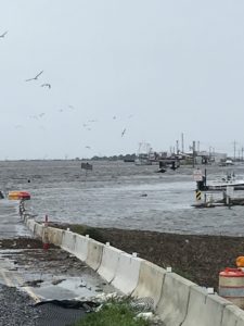
- LA 1 Below GM Lock
-
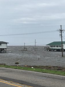
- LA 1 Below GM Lock
-
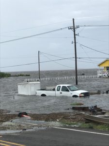
- Below GM Lock
-
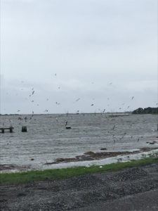
- Below GM Lock
-
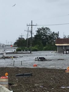
- Below GM Lock
-
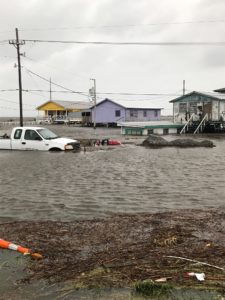
- Below GM Lock
-
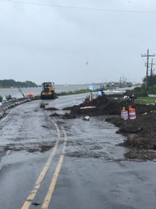
- Clearing Roadway of TS Barry Debris
-
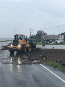
- Clearing Roadway of TS Barry Debris
WEATHER NOTICE 2 – POTENTIAL DISTURBANCE IN GULF OF MEXICO
WEATHER NOTICE 2 – POTENTIAL DISTURBANCE IN GULF OF MEXICO
Tuesday, July 9, 2019
4:15 p.m.
GLPC continues to monitor weather reports, as the potential for a tropical disturbance to develop in the Gulf of Mexico this week has slightly increased. There is now a 70% chance of development in the next 48 hours and an 80% chance of development within the next five days. Port Fourchon businesses and coastal residents should be alert, but not alarmed, and monitor communications for updates and warnings.
POSSIBLE IMPACTS IN THE PORT FOURCHON AREA
(Per National Weather Service update on 7/09/2019 @ 3:00 PM)
- Due to the large uncertainty of the strength and movement of the system, it is too soon to say what specific impacts it may have on the local area. Confidence on storm strength and movement remains LOW at this time.
- RAINFALL: Rainfall totals of 3 to 8 inches are possible through Monday, with a high chance of locally higher amounts. Coastal Flooding may become an issue as well later on this week.
- TIDES: Higher than normal tides possible, depending on the eventual track, size, and strength of the system.
- WINDS: Gusty winds possible, depending on the eventual track, size, and strength of the system.
- ROADWAYS: No closures anticipated at this time, but the potential is there.
NOTIFICATIONS AND WEATHER INFORMATION:
If you have signed up to any of our public information or emergency notification lists, e-mails, and/or social media, messages will be sent out regularly during a weather event with up-to-date information. If you would like to sign up for any notifications from the Port Commission, visit our NOTIFY ME page.
Visit the Port Commission’s WEATHER & STORM INFO webpage for links to current storm information, helpful storm prep information and resources, and contact updating forms.
We will continue to monitor this potential disturbance and keep you updated with any developing weather-related issues affecting port and airport.
2018 Hurricane Michael
Tropical Storm Michael Update #1
GLPC STORM WATCH
TROPICAL STORM MICHAEL
UPDATE #1
October 8, 2018
8:30 a.m.
Port Fourchon is in Storm Phase I: Storm Watch for Tropical Storm Michael. This means that GLPC is monitoring a tropical disturbance in the Gulf of Mexico. There are no watches in effect for our area at this time.
The National Hurricane Center has issued a Tropical Storm Watch for the Mississippi/Alabama border. Greatest impacts are expected to be east of the local area, with some higher than average tides along the coast.
There are no watches in effect for our coastal waters either, but if there are any westward adjustments to the storm track, they may be issued at some point. Port Fourchon businesses and coastal residents should be alert, but not alarmed, and monitor communications for updates and warnings.
Please review your facility’s hurricane plan, be thoughtful of stockpiling any loose material or excess items that could fly away or be damaged if Port Fourchon is affected by a storm, and make sure the Port Commission has your facility’s updated contact information so that you can receive timely storm-related information. There are no evacuation orders at this time.
NOTIFICATIONS AND WEATHER INFORMATION:
If you have signed up to any of our public information or emergency notification lists, e-mails, and/or social media, messages will be sent out regularly with up-to-date information. If you would like to sign up for any notifications from the Port Commission, visit our NOTIFY ME page.
Visit the Port Commission’s WEATHER AND STORM INFO webpage at portfourchon.com for links to current storm information, helpful storm prep information and resources, and contact updating information.
We will continue to evaluate the threat this weather poses and keep you updated with any developing weather-related issues.
Hurricane Michael Update #2
GLPC STORM WATCH
HURRICANE MICHAEL
UPDATE #2
October 9, 2018
8:30 a.m.
Port Fourchon remains in Storm Phase I: Storm Watch for Hurricane Michael. This means that GLPC is monitoring a tropical disturbance in the Gulf of Mexico. There are no watches or warnings for our area at this time. Michael’s greatest impacts are expected to be well to our east, with Tropical Storm Watches issued from the Mississippi Gulf Coast east of the Pearl River to the Florida panhandle.
A Coastal Flood Advisory remains in effect for the local area through tonight, with some higher than average tides along the coast. This may push some water onto LA 1 south of the Leon Theriot Lock in Golden Meadow during high tide late this evening, but we expect roadways to remain passable. We will be monitoring water levels along the route to Port Fourchon. Please drive carefully and be mindful of your surroundings, especially overnight. There are no expected road closures at this time.
Port Fourchon businesses and coastal residents should be alert, but not alarmed, and monitor communications for updates and warnings.
Please review your facility’s hurricane plan, be thoughtful of stockpiling any loose material or excess items that could fly away or be damaged if Port Fourchon is affected by a storm, and make sure the Port Commission has your facility’s updated contact information so that you can receive timely storm-related information. There are no evacuation orders at this time.
NOTIFICATIONS AND WEATHER INFORMATION:
If you have signed up to any of our public information or emergency notification lists, e-mails, and/or social media, messages will be sent out regularly with up-to-date information. If you would like to sign up for any notifications from the Port Commission, visit our NOTIFY ME page.
Visit the Port Commission’s WEATHER AND STORM INFO webpage at portfourchon.com for links to current storm information, helpful storm prep information and resources, and contact updating information.
We will continue to evaluate the threat this weather poses and keep you updated with any developing weather-related issues.
Hurricane Michael Update #3
GLPC STORM WATCH
HURRICANE MICHAEL
UPDATE #3
October 9, 2018
3:30 p.m.
Port Fourchon remains in Storm Watch phase while Hurricane Michael affects weather conditions along the Gulf Coast. There are no watches or warnings for our area at this time. Michael’s greatest impacts are expected to be well to our east, with Tropical Storm Watches issued from the Mississippi Gulf Coast east of the Pearl River to the Florida panhandle.
The Port Commission is closely monitoring conditions along the route to Port Fourchon, especially the stretch of LA 1 between Golden Meadow and Leeville. Water levels have dropped since early morning high tide, but conditions may deteriorate as Hurricane Michael and high tide approach tonight.
There are no expected road closures at this time, but a Coastal Flood Advisory remains in effect for the local area through tonight and there is potential for water to rise along low-lying areas of LA 1. Louisiana State Police, Lafourche Parish Sheriff’s Office, and GLPC Harbor Police will be onsite throughout the night to monitor the situation and maintain safety. Please drive carefully and be mindful of your surroundings, especially overnight.
Port Fourchon businesses and coastal residents should be alert, but not alarmed, and monitor communications for updates and warnings.
Please review your facility’s hurricane plan, be thoughtful of stockpiling any loose material or excess items that could fly away or be damaged if Port Fourchon is affected by a storm, and make sure the Port Commission has your facility’s updated contact information so that you can receive timely storm-related information. There are no evacuation orders at this time.
NOTIFICATIONS AND WEATHER INFORMATION:
If you have signed up to any of our public information or emergency notification lists, e-mails, and/or social media, messages will be sent out regularly with up-to-date information. If you would like to sign up for any notifications from the Port Commission, visit our NOTIFY ME page.
Visit the Port Commission’s WEATHER AND STORM INFO webpage at portfourchon.com for links to current storm information, helpful storm prep information and resources, and contact updating information.
We will continue to evaluate the threat this weather poses and keep you updated with any developing weather-related issues.
Hurricane Michael Update #4
GLPC STORM WATCH
HURRICANE MICHAEL
UPDATE #4
October 10, 2018
12:30 a.m.
Conditions have worsened on La Hwy 1 between Leon Theriot Flood Gates and Leeville as high tide approaches at approximately 1:45a.m. Essential travel in larger vehicles should take place at this time.
GLPC Harbor Police, Lafourche Parish Sheriff’s Office and Louisiana State Police are on scene in the most impacted areas of the Hwy restricting smaller vehicle traffic to protect the public’s safety.
NOTIFICATIONS AND WEATHER INFORMATION:
If you have signed up to any of our public information or emergency notification lists, e-mails, and/or social media, messages will be sent out regularly with up-to-date information. If you would like to sign up for any notifications from the Port Commission, visit our NOTIFY ME page.
Visit the Port Commission’s WEATHER AND STORM INFO webpage at portfourchon.com for links to current storm information, helpful storm prep information and resources, and contact updating information.
We will continue to evaluate the threat this weather poses and keep you updated with any developing weather-related issues.
Hurricane Michael Update #5
GLPC STORM PHASE I: STORM WATCH
HURRICANE MICHAEL
UPDATE #5
October 10, 2018
4:00 a.m.
Conditions are improving on La Hwy 1 between Leon Theriot Flood Gates and Leeville as tides are starting to go down. Hwy 1 is open to all traffic, but please use caution due to water still being on the roadways.
GLPC Harbor Police, Lafourche Parish Sheriff’s Office and Louisiana State Police are still on scene in the most impacted areas of the highway to protect the public’s safety.
NOTIFICATIONS AND WEATHER INFORMATION:
If you have signed up to any of our public information or emergency notification lists, e-mails, and/or social media, messages will be sent out regularly with up-to-date information. If you would like to sign up for any notifications from the Port Commission, visit our NOTIFY ME page.
Visit the Port Commission’s WEATHER AND STORM INFO webpage at portfourchon.com for links to current storm information, helpful storm prep information and resources, and contact updating information.
We will continue to evaluate the threat this weather poses and keep you updated with any developing weather-related issues.
Hurricane Michael Update #6 – FINAL UPDATE
GLPC STORM WATCH: FINAL UPDATE
HURRICANE MICHAEL
UPDATE #6
October 10, 2018
9:15 a.m.
Port Fourchon is ending Storm Watch for Hurricane Michael as threats from elevated water levels recede with the tide.
Conditions on the stretch of LA 1 from Golden Meadow to Leeville continue to improve as the tide goes down, and a cool front is anticipated to bring winds from the north and further diminish tidal impacts. The roads are open to all traffic, but please drive with caution through low-lying areas that may still have some water encroaching on the roadway or tide-related debris. We will monitor throughout the day and inform you if any issues arise tonight, although none are anticipated.
As always, we will continue to keep you updated with any developing weather-related issues.
Thank you for staying informed with us through this weather event.
2018 Tropical Storm Gordon
Tropical Storm Gordon Update #1
GLPC STORM WATCH
TROPICAL STORM GORDON
UPDATE #1
September 3, 2018
8:00 a.m.
The Port Commission is keeping an eye on Tropical Storm Gordon entering the Gulf of Mexico.
GLPC is moving to Storm Watch phase, which means that the Port Commission is monitoring the weather in the Gulf of Mexico for any signs of development or strengthening that may affect the Gulf Coast over the next several days. Businesses and coastal residents should be alert for new updates and warnings and need to be prepared to take quick action if necessary.
There are no evacuation orders at this time, impacts are anticipated to be heavy rain and elevated tide levels. Our main area of concern will be Hwy 1 between Leon Theriot Flood Gates in Golden Meadow and Elevated Hwy 1 in Leeville. Please review your facility’s hurricane plan, be thoughtful of stockpiling any loose material or excess items that could fly away or be damaged if Port Fourchon is affected by a storm, and make sure the Port Commission has your facility’s updated contact information so that you can receive timely storm-related information.
If you have signed up to any of our public information or emergency notification lists, e-mails, and/or social media, messages will be sent daily with up-to-date information. If you would like to sign up for any notifications from the Port Commission, visit our NOTIFY ME page.
Visit the Port Commission’s WEATHER AND STORM INFO webpage at portfourchon.com for links to current storm information, helpful storm prep information, and resources.
We will continue to evaluate the threat this weather poses and keep you updated with any developing weather-related issues.
Tropical Storm Gordon Update #2
GLPC STORM PHASE I: STORM WATCH
TROPICAL STORM GORDON
UPDATE #2
September 3, 2018
8:30 a.m.
The Port Commission is monitoring Tropical Storm Gordon entering the Gulf of Mexico.
GLPC is moving to Storm Phase 1, which means that the Port Commission is monitoring the weather in the Gulf of Mexico for further development or strengthening that may affect the Gulf Coast over the next several days. Businesses and coastal residents should be alert for new updates and warnings and need to be prepared to take quick action if necessary.
There are no evacuation orders at this time, impacts are anticipated to be heavy rain and elevated tide levels. Our main area of concern will be Hwy 1 between Leon Theriot Flood Gates in Golden Meadow and Elevated Hwy 1 in Leeville. Please review your facility’s hurricane plan, be thoughtful of stockpiling any loose material or excess items that could fly away or be damaged if Port Fourchon is affected by a storm, and make sure the Port Commission has your facility’s updated contact information so that you can receive timely storm-related information.
GLPC has opened the Emergency Storm Harbor Marina to commercial fishing vessels seeking safe harbor within the South Lafourche Levee System. Utilization of this marina will be on a first come, first served basis. Harbor Police will be on scene to monitor marina activity.
If you have signed up to any of our public information or emergency notification lists, e-mails, and/or social media, messages will be sent daily with up-to-date information. If you would like to sign up for any notifications from the Port Commission, visit our NOTIFY ME page.
Visit the Port Commission’s WEATHER AND STORM INFO webpage at portfourchon.com for links to current storm information, helpful storm prep information, and resources.
We will continue to evaluate the threat this weather poses and keep you updated with any developing weather-related issues.
Tropical Storm Gordon: Update #3
GLPC STORM PHASE II: VOLUNTARY EVACUATION
TROPICAL STORM GORDON
UPDATE #3
September 3, 2018
10:30 a.m.
The Port Commission is moving to Storm Phase II: Voluntary Evacuation status for Tropical Storm Gordon due to anticipation of water encroaching on the low-lying area of LA 1 between Golden Meadow and Leeville sometime late Tuesday. Roads are currently open to vehicular traffic, but this may potentially transition to road closure as tides begin rise. Please keep this in mind as you plan any travel below the Golden Meadow lock.
Port Fourchon Harbor Police will be monitoring the condition of the roadway overnight, and the Port Commission will send out updates as they become available.
Tropical Storm Gordon is still expected to bring rain bands and squalls in waves, with the potential for heavy rainfall, flash flooding, and isolated tornadoes.
Businesses and coastal residents should be alert for new updates and warnings and need to be prepared to take quick action if necessary. Please review your facility’s hurricane plan, be thoughtful of stockpiling any loose material or excess items that could fly away or be damaged if Port Fourchon is affected by a storm, and make sure the Port Commission has your facility’s updated contact information so that you can receive timely storm-related information.
GLPC has opened the Emergency Storm Harbor Marina to commercial fishing vessels seeking safe harbor within the South Lafourche Levee System. Utilization of this marina will be on a first come, first served basis. Harbor Police will be on scene to monitor marina activity.
If you have signed up to any of our public information or emergency notification lists, e-mails, and/or social media, messages will be sent daily with up-to-date information. If you would like to sign up for any notifications from the Port Commission, visit our NOTIFY ME page.
Visit the Port Commission’s WEATHER AND STORM INFO webpage at portfourchon.com for links to current storm information, helpful storm prep information, and resources.
We will continue to evaluate the threat this weather poses and keep you updated with any developing weather-related issues.
Tropical Storm Gordon: Update #4
GLPC STORM PHASE II: VOLUNTARY EVACUATION
TROPICAL STORM GORDON
UPDATE #4
September 3, 2018
5:00 p.m.
Port Fourchon is in Storm Phase II: Voluntary Evacuation, due to anticipation of water encroaching on the low-lying area of LA 1 between Golden Meadow and Leeville over the next few days.
Roads are currently open to vehicular traffic, but this may potentially transition to road closure if tides rise sometime late Tuesday evening into early Wednesday morning. Please keep this in mind as you plan any travel below the Golden Meadow lock.
Port Fourchon Harbor Police will be monitoring the condition of the roadway, and the Port Commission will send out updates as they become available.
Tropical Storm Gordon is still expected to bring rain bands and squalls in waves, with the potential for heavy rainfall and flash flooding.
Businesses and coastal residents should be alert for new updates and warnings and need to be prepared to take quick action if necessary. Please review your facility’s hurricane plan, be thoughtful of stockpiling any loose material or excess items that could fly away or be damaged if Port Fourchon is affected by a storm, and make sure the Port Commission has your facility’s updated contact information so that you can receive timely storm-related information.
NOTE: GLPC has opened the Emergency Storm Harbor Marina to commercial fishing vessels seeking safe harbor within the South Lafourche Levee System. Utilization of this marina will be on a first come, first served basis. Harbor Police will be on scene to monitor marina activity. Visit this link to view the GLPC Ordinance No. 74 regarding Storm Harbor Marina use:
https://portfourchon.com/wp-content/uploads/Ordinance74.pdf
If you have signed up to any of our public information or emergency notification lists, e-mails, and/or social media, messages will be sent daily with up-to-date information. If you would like to sign up for any notifications from the Port Commission, visit our NOTIFY ME page.
Visit the Port Commission’s WEATHER AND STORM INFO webpage at portfourchon.com for links to current storm information, helpful storm prep information, and resources.
We will continue to evaluate the threat this weather poses and keep you updated with any developing weather-related issues.
Tropical Storm Gordon: Update #5
GLPC STORM PHASE II: VOLUNTARY EVACUATION
TROPICAL STORM GORDON
UPDATE #5
September 4, 2018
8:45 a.m.
Port Fourchon remains in Storm Phase II: Voluntary Evacuation due to anticipation of water encroaching on the low-lying area of LA 1 between Golden Meadow and Leeville over the next few days. While Tropical Storm Gordon is expected to strengthen into a category 1 hurricane before landfall, impacts to our area are expected to be minimal and indirect.
Roads are currently open to vehicular traffic, but this may potentially transition to road closure if tides rise sometime late Tuesday evening into early Wednesday morning. Please keep this in mind as you plan any travel below the Golden Meadow lock.
Port Fourchon Harbor Police, Lafourche Parish Sheriff’s Office, and Louisiana State Police will be monitoring the condition of the roadway, and the Port Commission will send out updates as they become available.
Tropical Storm Gordon is still expected to bring rain bands, high tides, and some minimal wind gusts with the potential for heavy rainfall and flash flooding.
Businesses and coastal residents should be alert for new updates and warnings and need to be prepared to take quick action if necessary. Please review your facility’s hurricane plan, be thoughtful of stockpiling any loose material or excess items that could fly away or be damaged if Port Fourchon is affected by a storm, and make sure the Port Commission has your facility’s updated contact information so that you can receive timely storm-related information.
NOTE: GLPC has opened the Emergency Storm Harbor Marina to commercial fishing vessels seeking safe harbor within the South Lafourche Levee System. Utilization of this marina will be on a first come, first served basis. Harbor Police will be on scene to monitor marina activity. Visit this link to view the GLPC Ordinance No. 74 regarding Storm Harbor Marina use: https://portfourchon.com/wp-content/uploads/Ordinance74.pdf
If you have signed up to any of our public information or emergency notification lists, e-mails, and/or social media, messages will be sent daily with up-to-date information. If you would like to sign up for any notifications from the Port Commission, visit our NOTIFY ME page.
Visit the Port Commission’s WEATHER AND STORM INFO webpage at portfourchon.com for links to current storm information, helpful storm prep information, and resources.
We will continue to evaluate the threat this weather poses and keep you updated with any developing weather-related issues.
Tropical Storm Gordon: Update #6
GLPC STORM PHASE II: VOLUNTARY EVACUATION
TROPICAL STORM GORDON
UPDATE #6
September 4, 2018
3:00 p.m.
In an abundance of caution, Port Fourchon remains in Storm Phase II: Voluntary Evacuation due to the possibility of water encroaching on the low-lying area of LA 1 between Golden Meadow and Leeville during storm conditions. The threat of Tropical Storm Gordon has diminished over the course of the day, and the Tropical Storm Warning for Lafourche Parish has been canceled. Impacts to our area are expected to be minimal and indirect.
Roads are currently open to vehicular traffic. This may potentially transition to road closure if tides rise significantly this evening into early Wednesday. Please keep this in mind as you plan any travel below the Golden Meadow lock.
Port Fourchon Harbor Police, Lafourche Parish Sheriff’s Office, and Louisiana State Police will be monitoring the condition of the roadway, and the Port Commission will send out updates as they become available.
Tropical Storm Gordon is still expected to bring rain and elevated tides.
Businesses and coastal residents should be alert for new updates and warnings and need to be prepared to take quick action if necessary. Please review your facility’s hurricane plan, be thoughtful of stockpiling any loose material or excess items that could fly away or be damaged if Port Fourchon is affected by a storm, and make sure the Port Commission has your facility’s updated contact information so that you can receive timely storm-related information.
NOTE: GLPC has opened the Emergency Storm Harbor Marina to commercial fishing vessels seeking safe harbor within the South Lafourche Levee System. Utilization of this marina will be on a first come, first served basis. Harbor Police will be on scene to monitor marina activity. Visit this link to view the GLPC Ordinance No. 74 regarding Storm Harbor Marina use: https://portfourchon.com/wp-content/uploads/Ordinance74.pdf
If you have signed up to any of our public information or emergency notification lists, e-mails, and/or social media, messages will be sent daily with up-to-date information. If you would like to sign up for any notifications from the Port Commission, visit our NOTIFY ME page.
Visit the Port Commission’s WEATHER AND STORM INFO webpage at portfourchon.com for links to current storm information, helpful storm prep information, and resources.
We will continue to evaluate the threat this weather poses and keep you updated with any developing weather-related issues.
Tropical Storm Gordon: Update #7
GLPC STORM WATCH: FINAL UPDATE
TROPICAL STORM GORDON
UPDATE #7
September 5, 2018
7:00 a.m.
Port Fourchon is ending all GLPC Storm Phases for Tropical Storm Gordon and returning to normal operations. This will be our final update.
All roads are open to vehicular traffic, including LA 1 from Golden Meadow to Leeville, and there is no water encroaching on roadways leading to Port Fourchon. All watches and warnings have ended.
As always, we will continue to keep you updated with any developing weather-related issues.
Thank you for staying informed with us through this weather event.
EMERGENCY STORM HARBOR MARINA:
With the end of this storm, the Emergency Storm Harbor Marina has been deactivated and is being closed. All vessels in the marina must be cleared per ordinance guidelines.
Visit this link to view the GLPC Ordinance No. 74 regarding Storm Harbor Marina use: https://portfourchon.com/wp-content/uploads/Ordinance74.pdf
NOTIFICATIONS AND WEATHER INFORMATION:
If you have signed up to any of our public information or emergency notification lists, e-mails, and/or social media, messages will be sent daily with up-to-date information. If you would like to sign up for any notifications from the Port Commission, visit our NOTIFY ME page.
Visit the Port Commission’s WEATHER AND STORM INFO webpage at portfourchon.com for links to current storm information, helpful storm prep information, and resources.
2017 Tropical Storm Harvey
GLPC Storm Watch: Update #5 – Wednesday, August 30
GLPC STORM WATCH: Tropical Storm Harvey
UPDATE #5
August 30, 2017
3:15 p.m.
LA 1 will remain open to SINGLE LANE traffic in a convoy behind law enforcement vehicles from south of the Golden Meadow floodgates to the LA 1 Expressway toll bridge entrance in Leeville. Drivers can expect delays while these traffic restrictions are in place.
Stay safe and focused on the roadway.
GLPC Storm Watch: Update #6 – Wednesday, August 30
GLPC STORM WATCH: Tropical Storm Harvey
UPDATE #6
August 30, 2017
7:30 p.m.
LA 1 will remain OPEN overnight. Conditions have improved, and TWO LANE travel is back open to and from Port Fourchon with no convoy required. Our Harbor Police continue to monitor conditions and we will provide updates if conditions change.
There is still water on the roadway in some sections, so SLOW DOWN and drive safely.
GLPC Storm Watch: Update #7 – Thursday, August 31
GLPC STORM WATCH: Tropical Depression Harvey
UPDATE #7
August 31, 2017
11:10 a.m.
LA 1 is clear of water from Port Fourchon to Golden Meadow this morning, and while some water on the roadway is possible in low spots approaching high tide, the worst of the conditions have passed.
There is NO anticipated closure of the roadway, and this will be the final update.
Please continue to drive safely.
2017 Tropical Storm Cindy
GLPC Storm Watch: Update #1
GLPC STORM WATCH: POTENTIAL TROPICAL DISTURBANCE IN THE GULF
UPDATE #1
June 19, 2017
4:00 p.m.
The Port Commission is keeping an eye on the potential for tropical weather development in the Gulf.
GLPC is moving to Storm Watch phase, which means that the Port Commission is monitoring the weather in the Gulf of Mexico for any signs of development or strengthening that may affect the Gulf Coast over the next several days. Businesses and coastal residents should be alert for new updates and warnings and need to be prepared to take quick action if necessary.
There are no evacuation orders at this time, and little to no impacts are anticipated for the Louisiana coast aside from heavy rain and slightly elevated tide levels. Even so, please review your facility’s hurricane plan, be thoughtful of stockpiling any loose material or excess items that could fly away or be damaged if Port Fourchon is affected by a storm, and make sure the Port Commission has your facility’s updated contact information so that you can receive timely storm-related information.
If you have signed up to any of our public information or emergency notification lists, e-mails, and/or social media, messages will be sent daily with up-to-date information. If you would like to sign up for any notifications from the Port Commission, visit our NOTIFY ME page.
Visit the Port Commission’s WEATHER AND STORM INFO webpage at portfourchon.com for links to current storm information, helpful storm prep information and resources, a link to GLPC’s Crisis Communication System login page, and contact updating forms.
We will continue to evaluate the threat this weather poses and keep you updated with any developing weather-related issues.
GLPC Storm Watch: Update #2
GLPC STORM WATCH: POTENTIAL TROPICAL CYCLONE THREE
UPDATE #2
June 20, 2017
8:30 a.m.
A Tropical Storm Warning and a Flash Flood Watch are in effect for much of the Southeastern Louisiana coast. The Port Commission remains in Storm Watch phase and is keeping an eye on the tropical weather development in the Gulf.
Anticipated impacts in the Port Fourchon area are heavy rainfall and slightly elevated tide levels. The current tide level is 1.5 feet at Nerby Collins Marina, which is a little above normal, and water is not a threat at this time. The National Weather Service is forecasting 4-8 inches of rain, and tides could rise 1-3 feet above normal.
Businesses and coastal residents should be alert for new updates and warnings and need to be prepared to take quick action if necessary. Please review your facility’s hurricane plan, be thoughtful of stockpiling any loose material or excess items that could fly away or be damaged if Port Fourchon is affected by a storm, and make sure the Port Commission has your facility’s updated contact information so that you can receive timely storm-related information.
If you have signed up to any of our public information or emergency notification lists, e-mails, and/or social media, messages will be sent daily with up-to-date information. If you would like to sign up for any notifications from the Port Commission, visit our NOTIFY ME page.
Visit the Port Commission’s WEATHER AND STORM INFO webpage at portfourchon.com for links to current storm information, helpful storm prep information and resources, a link to GLPC’s Crisis Communication System login page, and contact updating forms.
We will continue to evaluate the threat this weather poses and keep you updated with any developing weather-related issues.
GLPC Storm Watch: Update #3
GLPC STORM WATCH: TROPICAL STORM CINDY
UPDATE #3
June 20, 2017
3:00 p.m.
A Tropical Storm Warning and a Flash Flood Watch are in effect for much of the Southeastern Louisiana coast as the tropical system has developed enough to be given the name of Tropical Storm Cindy. The Port Commission remains in Storm Watch phase and is keeping an eye on TS Cindy’s development.
Anticipated impacts in the Port Fourchon area are heavy rainfall and slightly elevated tide levels. The current tide level is 1.5 feet at Nerby Collins Marina, which is a little above normal, and water is not a threat at this time. The National Weather Service is forecasting 4-8 inches of rain, and tides could rise 1-3 feet above normal. Winds are not projected to get above 45 miles per hour.
The Lady of the Sea Medical Clinic – Fourchon will be closed for business Wednesday and possibly Thursday due to this week’s weather forecast.
Businesses and coastal residents should be alert for new updates and warnings and need to be prepared to take quick action if necessary. Please review your facility’s hurricane plan, be thoughtful of stockpiling any loose material or excess items that could fly away or be damaged if Port Fourchon is affected by a storm, and make sure the Port Commission has your facility’s updated contact information so that you can receive timely storm-related information.
If you have signed up to any of our public information or emergency notification lists, e-mails, and/or social media, messages will be sent daily with up-to-date information. If you would like to sign up for any notifications from the Port Commission, visit our NOTIFY ME page.
Visit the Port Commission’s WEATHER AND STORM INFO webpage at portfourchon.com for links to current storm information, helpful storm prep information and resources, a link to GLPC’s Crisis Communication System login page, and contact updating forms.
We will continue to evaluate the threat this weather poses and keep you updated with any developing weather-related issues.
GLPC Storm Watch: Update #4 (Phase II: Voluntary Evacuation)
GLPC STORM PHASE II: VOLUNTARY EVACUATION
Tropical Storm Cindy
UPDATE #4
June 20, 2017
6:00 p.m.
Port Fourchon is in Storm Phase II, which is Voluntary Evacuation. While this system is not predicted to make landfall in the Port Fourchon area, a Tropical Storm Warning and a Flash Flood Watch are in effect for much of the Southeastern Louisiana coast and rising water levels in low-lying areas may overtop roadways.
The section of LA 1 south of the Leon Theriot Lock in Golden Meadow is currently open, but we are monitoring rising water levels that may impact the road condition for a short period of time tonight or early tomorrow. Please keep the potential for road closures in mind as you plan any travel below the lock.
Port Fourchon Harbor Police will be monitoring the condition of the roadway overnight, and the Port Commission will send out updates as they become available.
Businesses and coastal residents should be alert for new updates and warnings and need to be prepared to take quick action if necessary. Please review your facility’s hurricane plan, be thoughtful of stockpiling any loose material or excess items that could fly away or be damaged if Port Fourchon is affected by a storm, and make sure the Port Commission has your facility’s updated contact information so that you can receive timely storm-related information.
If you have signed up to any of our public information or emergency notification lists, e-mails, and/or social media, messages will be sent daily with up-to-date information. If you would like to sign up for any notifications from the Port Commission, visit our NOTIFY ME page.
Visit the Port Commission’s WEATHER AND STORM INFO webpage at portfourchon.com for links to current storm information, helpful storm prep information and resources, a link to GLPC’s Crisis Communication System login page, and contact updating forms.
We will continue to evaluate the threat this weather poses and keep you updated with any developing weather-related issues.
GLPC Storm Watch: Update #5 (Voluntary Evacuation Rescinded)
GLPC STORM WATCH: TROPICAL STORM CINDY
UPDATE #5
June 21, 2017
8:30 a.m.
The Port Commission is rescinding Phase II: Voluntary Evacuation status for Tropical Storm Cindy and returning to Phase I: Storm Watch. All roads are open to vehicular traffic, and crews are clearing any debris gathered along roadways as waters recede. Please use caution and watch for crews, equipment, and debris along your route.
Tropical Storm Cindy will still bring rain bands and squalls in waves throughout the day. Expect heavy rainfall and the potential for flooding and isolated tornadoes.
Tides are holding steady at 1-3 feet above normal. High winds have peaked, but occasional gusts from 25 to 45 miles per hour will be a part of the storm’s effects.
The Lady of the Sea Medical Clinic – Fourchon is closed for business today and possibly tomorrow due to this week’s weather forecast.
Businesses and coastal residents should be alert for new updates and warnings and need to be prepared to take quick action if necessary. Please review your facility’s hurricane plan, be thoughtful of stockpiling any loose material or excess items that could fly away or be damaged if Port Fourchon is affected by a storm, and make sure the Port Commission has your facility’s updated contact information so that you can receive timely storm-related information.
If you have signed up to any of our public information or emergency notification lists, e-mails, and/or social media, messages will be sent daily with up-to-date information. If you would like to sign up for any notifications from the Port Commission, visit our NOTIFY ME page.
Visit the Port Commission’s WEATHER AND STORM INFO webpage at portfourchon.com for links to current storm information, helpful storm prep information and resources, a link to GLPC’s Crisis Communication System login page, and contact updating forms.
We will continue to evaluate the threat this weather poses and keep you updated with any developing weather-related issues.
GLPC Storm Watch: Update #6 (Voluntary Evacuation Reinstated)
GLPC STORM PHASE II: VOLUNTARY EVACUATION
Tropical Storm Cindy
UPDATE #6
June 21, 2017
3:00 p.m.
In an abundance of caution, the Port Commission is reinstating Phase II: Voluntary Evacuation status for Tropical Storm Cindy due to water encroaching on the low-lying area of LA 1 between Golden Meadow and Leeville. Roads are currently open to vehicular traffic, but this may potentially transition to road closure as tides rise this evening. Please keep this in mind as you plan any travel below the Golden Meadow lock.
Port Fourchon Harbor Police will be monitoring the condition of the roadway overnight, and the Port Commission will send out updates as they become available.
Tropical Storm Cindy is still expected to bring rain bands and squalls in waves through Thursday, with the potential for heavy rainfall, flash flooding, and isolated tornadoes.
Tides are holding steady at 1-3 feet above normal. High winds have peaked, but occasional gusts from 25 to 45 miles per hour will be a part of the storm’s effects.
Businesses and coastal residents should be alert for new updates and warnings and need to be prepared to take quick action if necessary. Please review your facility’s hurricane plan, be thoughtful of stockpiling any loose material or excess items that could fly away or be damaged if Port Fourchon is affected by a storm, and make sure the Port Commission has your facility’s updated contact information so that you can receive timely storm-related information.
If you have signed up to any of our public information or emergency notification lists, e-mails, and/or social media, messages will be sent daily with up-to-date information. If you would like to sign up for any notifications from the Port Commission, visit our NOTIFY ME page.
Visit the Port Commission’s WEATHER AND STORM INFO webpage at portfourchon.com for links to current storm information, helpful storm prep information and resources, a link to GLPC’s Crisis Communication System login page, and contact updating forms.
We will continue to evaluate the threat this weather poses and keep you updated with any developing weather-related issues.
GLPC Storm Watch: Update #7 (Voluntary Evacuation Rescinded)
GLPC STORM WATCH: TROPICAL STORM CINDY
UPDATE #7
June 22, 2017
9:00 a.m.
The Port Commission is rescinding Phase II: Voluntary Evacuation status for Tropical Storm Cindy and returning to Phase I: Storm Watch. We are remaining in Storm Watch phase to monitor water levels along roadways, as high tide today is around noon and water levels may continue to rise.
All roads are open to vehicular traffic, including LA 1 from Golden Meadow to Grand Isle, and crews are clearing any debris gathered along roadways from storm waters. Please use caution and watch for crews, equipment, and debris along your route.
Cindy has made landfall in southwest Louisiana, and the Tropical Storm Warning is no longer in effect. We are still under a Flash Flood Watch through this evening, especially in coastal areas. The storm’s associated Tornado Watch ends at 1:00 p.m. today.
The Lady of the Sea Medical Clinic – Fourchon is closed for business today.
Businesses and coastal residents should be alert for new updates and warnings and need to be prepared to take quick action if necessary. Please review your facility’s hurricane plan, be thoughtful of stockpiling any loose material or excess items that could fly away or be damaged if Port Fourchon is affected by a storm, and make sure the Port Commission has your facility’s updated contact information so that you can receive timely storm-related information.
If you have signed up to any of our public information or emergency notification lists, e-mails, and/or social media, messages will be sent daily with up-to-date information. If you would like to sign up for any notifications from the Port Commission, visit our NOTIFY ME page.
Visit the Port Commission’s WEATHER AND STORM INFO webpage at portfourchon.com for links to current storm information, helpful storm prep information and resources, a link to GLPC’s Crisis Communication System login page, and contact updating forms.
We will continue to evaluate the threat this weather poses and keep you updated with any developing weather-related issues.
GLPC Storm Watch: Update #8 (Final TS Cindy Update)
GLPC STORM WATCH: FINAL TROPICAL STORM CINDY UPDATE
UPDATE #8
June 22, 2017
2:00 p.m.
The Port Commission is ending all GLPC Storm Phases for Tropical Storm Cindy and returning to normal operations.
All roads are open to vehicular traffic, including LA 1 from Golden Meadow to Grand Isle, and any water still encroaching on roadways is dropping quickly. Crews are clearing any debris gathered along roadways as waters recede, so please use caution, drive safely, and watch for crews, equipment, and debris along your route.
The Tropical Storm Warning and Tornado Watch associated with Tropical Storm Cindy have ended. Some winds and rain may linger through this evening, especially in coastal areas, but with minimal impact.
Feel free to visit the Port Commission’s WEATHER AND STORM INFO webpage at portfourchon.com for links to current storm information, helpful storm prep information and resources, a link to GLPC’s Crisis Communication System login page, and contact updating forms.
As always, we will continue to keep you updated with any developing weather-related issues.
Thank you for staying informed with us through this weather event.